Situation Summary
Myanmar remains in active armed conflict between the junta military and coordinated resistance forces across multiple regions, with sustained clashes reported in Magway, Sagaing, Kachin, and Rakhine over the past 48 hours. Composite threat score of 94 places Myanmar at #23 globally, driven primarily by conventional military operations, political repression, and administrative friction with external actors. A concurrent monsoon system is amplifying travel and infrastructure risk nationwide. The security picture shows no signs of de-escalation; resistance operations are coordinated and operational momentum remains distributed across front-line zones.
Key Developments
- Saw Township, Magway Region (13–14 July): Resistance forces ambushed a junta military convoy on the Pon Taung Nat Htit–Kyaukhtu axis, killing at least 10 troops and triggering over 20 defections. Road-movement risk on this corridor remains acute.
- Mingin Township, Sagaing Region (13–14 July): Coordinated resistance attacks struck junta ground and naval assets on the Chindwin River, with at least 20 junta troops reported killed. Riverine and ground routes through Sagaing are now actively contested.
- Hkawnglanghpu area, Kachin State (13–14 July): Kachin Independence Army (KIA) captured two junta outposts, signaling active front-line movement in northern Kachin and elevated risk of reprisal operations in border zones.
- Mingin Township, Sagaing Region (13–14 July): Ko San Tin Htun, chairman of the Sagaing Revolution Force executive committee, escaped junta detention; his girlfriend was subsequently arrested. Follow-on search and arrest operations are likely in Sagaing.
- Nationwide (13–14 July forecast): A strengthening monsoon low-pressure system is driving heavy rain and flood risk across at least ten states and regions, compounding travel and bridge/road infrastructure disruption risk during active conflict.
- Broader 48-hour pattern: Consolidated resistance operations across Magway, Sagaing, Kachin, and Rakhine indicate sustained multi-front coordination and operational capability despite junta air and ground superiority.
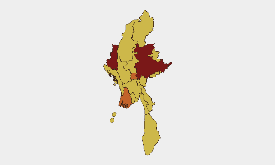
Highest-Risk Areas
Shan State (95.6) dominates the sub-national ranking and reflects sustained ethnic armed organization activity, trafficking networks, and strategic proximity to China and Thailand. Chin, Ayeyarwady, and the northern belt (Tanintharyi, Sagaing, Kachin, and Magway regions) all rank 65–77, indicating active conflict zones, resistance strongholds, and junta counter-operations. Notably, even lower-risk designations (Yangon, Naypyitaw, Mandalay at 65.6) reflect political repression and detention risks; secondary cities remain under junta surveillance and control. Geographic spread of risk underscores that no region is conflict-free; personnel and asset risk varies by exact location and operational profile.
How GeoBit Would Assist
Teams with staff or assets in Myanmar should prioritize AOI Monitoring & Early Warning (persistent watch on high-risk townships like Mingin, Saw, and Hkawnglanghpu with alerting on clashes and detentions), Routing & Network Analysis (alternative journey planning around active conflict corridors and flood-prone roads), and Conflict & Military intelligence (real-time battle mapping and force-posture tracking). Intel Sweep across Telegram resistance channels, domestic news, and multi-language OSINT would flag checkpoint movements, unit reorganizations, and arrest operations 12–48 hours ahead of wider dissemination.
7-Day Outlook
Resistance momentum is likely to sustain across Sagaing, Magway, and Kachin through late July as monsoon conditions restrict junta air operations and favor ground ambushes. Detention and reprisal risks will spike in areas where resistance leaders escape or are captured. Travel risk remains critical; personnel should assume road delays, checkpoints, and infrastructure disruption through the monsoon season.
Highest-Risk Areas — Ranked
| # | State / Region | Risk |
|---|---|---|
| 1 | Shan State | 95.6 |
| 2 | Chin | 76.8 |
| 3 | Ayeyarwady | 69.3 |
| 4 | Tanintharyi Region | 65.6 |
| 5 | Sagaing Region | 65.6 |
| 6 | Kachin State | 65.6 |
| 7 | Wa State (Northern Region) | 65.6 |
| 8 | Magway | 65.6 |
| 9 | Mandalay | 65.6 |
| 10 | Rakhine | 65.6 |
| 11 | Yangon | 65.6 |
| 12 | Naypyitaw Union Territory | 65.6 |
Sources
Previous Daily Briefs
A new Myanmar brief is written every day — each with its own risk map and downloadable CSV. Here's the last week; use the calendar to go further back.
📅 Browse every day by calendar →
Highlighted days have a brief. Tap a day for that day's map & analysis, or “csv” for that day's dataset ($5).
Atlas — our AI intelligence desk — emails them this snapshot personally. Nothing else, no list.