Situation Summary
Niger remains at elevated operational risk (global rank #23, composite threat score 69.6), driven primarily by persistent insurgency in the northern and eastern regions and a protracted state of emergency affecting movement and services countrywide. As of late January 2026, the U.S. State Department ordered non-emergency U.S. government personnel to depart and maintains a "Do Not Travel" advisory due to terrorism, kidnapping, and criminal activity. Open-source reporting over the last 24–48 hours does not surface specific new incident details; however, the absence of public incident reporting should not be construed as a reduction in underlying threat—information gaps are endemic in conflict zones with restricted access.
Key Developments
Information Gap Alert: GeoBit's real-time web research (last 24 hours) did not yield specific, date-stamped security incidents in Niger for the period 2026-06-04 to 2026-06-05. Event feeds show administrative and political signals originating in Nigeria and affecting regional actors, but no confirmed localized attacks, abductions, or clashes within Niger proper in the immediate 48-hour window.
- Ongoing State of Emergency: Movement restrictions and emergency measures remain in effect across multiple regions; U.S. government ability to provide consular assistance outside Niamey is severely constrained.
- Regional Spillover Risk: Nigeria-linked political and administrative tensions (arrests, sanctions, military demands noted in event feeds) may indirectly affect Niger's border security posture, particularly in Diffa and Tillabéri regions.
- No Confirmed Major Incident (24–48h): Despite persistent underlying threats, no verified large-scale attack, hostage-taking, or armed clash has been reported in open sources since 2026-06-04 EOD.
Operational Note: Duty-of-care teams should treat the lack of recent public incident reporting as an information void, not evidence of safety improvement. Organizations with personnel or assets in Niger should rely on internal intelligence, direct in-country contacts, and real-time alerting platforms (Crisis24, GardaWorld, INSO) for granular situational awareness.
Highest-Risk Areas
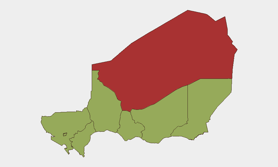
Agadez Region dominates the sub-national risk ranking (78.7), substantially exceeding all other regions and reflecting its proximity to terrorist sanctuaries in Mali and Burkina Faso, porous borders, and history of AQIM and ISIS-affiliated activity. Zinder, Diffa, and Tillabéri regions all register at 48.7—moderately elevated but significantly lower than Agadez—and present sustained risk from cross-border incursions, banditry, and kidnapping networks. Notably, Niamey itself scores 48.7, indicating that even the capital faces material security concerns despite its status as the seat of government; criminal activity, protest dynamics, and insider threats warrant continuous monitoring. The northern and eastern arc (Agadez–Diffa–Tillabéri) remains the primary battlespace for counterterrorism operations and illicit activity.
How GeoBit Would Assist
AOI Monitoring & Early Warning would establish persistent watch over Agadez, Diffa, and Tillabéri with alerts for cross-border movement, armed group activity, and checkpoint incidents. OSINT Fusion (multi-language social media, Telegram threat networks, radio SIGINT) combined with Conflict & Military tracking (force structure, weapons capability) would provide early indicators of planned operations or group repositioning. GIS & Spatial Analysis and Routing & Network Analysis would support journey planning for personnel and asset convoys, identifying alternative routes and safe zones and assessing real-time corridor risk.
7-Day Outlook
No imminent large-scale tactical shift is signaled in current data; however, the insurgency is unlikely to abate in the near term, and border security will remain volatile. Organizations should expect continued administrative friction, checkpoint delays, and sporadic criminal activity. Risk trajectory remains flat to slowly degrading; any material change (major attack, leadership transition, or military operation announcement) should trigger immediate re-assessment.
Highest-Risk Areas — Ranked
| # | State / Region | Risk |
|---|---|---|
| 1 | Agadez Region | 78.7 |
| 2 | Zinder Region | 48.7 |
| 3 | Diffa Region | 48.7 |
| 4 | Tillabéri Region | 48.7 |
| 5 | Niamey | 48.7 |
| 6 | Tahoua Region | 48.7 |
| 7 | Dosso Region | 48.7 |
| 8 | Maradi Region | 48.7 |
Sources
Previous Daily Briefs
A new Niger brief is written every day — each with its own risk map and downloadable CSV. Here's the last week; use the calendar to go further back.
📅 Browse every day by calendar →
Highlighted days have a brief. Tap a day for that day's map & analysis, or “csv” for that day's dataset ($5).