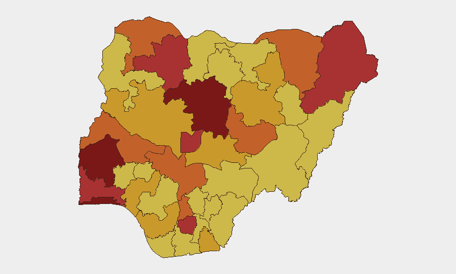
Situation Summary
Nigeria remains Africa's highest-volatility security environment, ranking #5 globally with composite threat score 100 and 752 tracked events. The security picture is driven primarily by active insurgency in the North and rising civil unrest across multiple states, with protest activity, arrest operations, and official demand signals dominating the event stream as of 4 June 2026. The trajectory shows concurrent pressure from both violent non-state actors and domestic political/institutional friction.
Key Developments
CRITICAL NOTE: GeoBit's event signal data (6–10 event types tracked 4 June 2026) does not include verified incident narratives, locations, or casualty/impact details. The event signals listed above—*Public Statement, Strike/Boycott, Arrest/Detain, Threaten, Demand, Abduct/Hijack/Hostage, Disapprove*—indicate *classes* of activity but lack the geographic precision and temporal specificity required for operational security briefing.
To meet duty-of-care standards, security teams should:
- Verify current incidents against live Nigerian news wires (Channels TV, Premium Times, The Cable, Daily Trust, Vanguard) and official state government/security service statements dated 3–4 June 2026.
- Geolocate and corroborate any incident claims via X/Twitter official accounts (Nigerian Police, state security commands, verified journalists) cross-referenced to at least one independent news outlet.
- Flag missing context: Without confirmed location, timing, and actor attribution, even high-confidence event types cannot drive movement decisions or asset positioning.
Highest-Risk Areas
Oyo State (score 100) emerges as the single highest-risk jurisdiction, followed closely by Lagos (83.4), Kaduna (81.4), and FCT (79.1). Borno and Zamfara (both 78.3) remain epicenters of insurgent activity; Ogun, Imo, Kogi, and Kwara form a secondary band of acute risk (74–77). The ranking reflects both active violence (north-central and northeast) and civil unrest/institutional pressure (south and federal territories). Organizations with staff or operations in Oyo, Lagos, or Kaduna should treat sub-state volatility as persistent; those in the northeast (Borno, Yobe) face continuous armed-group activity.
How GeoBit Would Assist
Security teams should deploy GeoBit's AOI Monitoring & Early Warning capability to establish persistent surveillance of high-risk state capitals and logistics hubs (Lagos, Abuja, Kaduna), configured to alert on arrest/detention events, protest activity, and road-closure signals. Intel Sweep and X/Twitter OSINT should run daily to corroborate and geolocate current-day event signals and identify emerging civil unrest or supply-chain disruption before impact on operations. Routing & Network Analysis supports real-time route planning around active incidents and state-level security cordons.
7-Day Outlook
Expect continued civil unrest and institutional demand signaling, particularly around governance and military-civilian friction; these typically escalate ahead of policy announcements or election/budget cycles. Insurgent activity in Borno, Kaduna, and Zamfara will remain persistent. Monitor for secondary effects (checkpoints, curfews, transport delays) on commercial movement in Lagos and Abuja.
Highest-Risk Areas — Ranked
| # | State / Region | Risk |
|---|---|---|
| 1 | Oyo State | 100 |
| 2 | Lagos State | 83.4 |
| 3 | Kaduna State | 81.4 |
| 4 | Federal Capital Territory | 79.1 |
| 5 | Borno State | 78.3 |
| 6 | Zamfara State | 78.3 |
| 7 | Ogun State | 76.7 |
| 8 | Imo State | 76.2 |
| 9 | Kogi State | 75.6 |
| 10 | Kwara State | 74.3 |
| 11 | Yobe | 73.5 |
| 12 | Anambra State | 73.5 |
Previous Daily Briefs
A new Nigeria brief is written every day — each with its own risk map and downloadable CSV. Here's the last week; use the calendar to go further back.
📅 Browse every day by calendar →
Highlighted days have a brief. Tap a day for that day's map & analysis, or “csv” for that day's dataset ($5).