Situation Summary
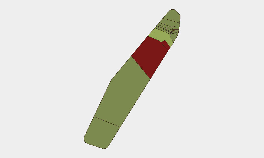
Palau remains internally stable with no verified security incidents, civil unrest, terrorism, or infrastructure disruptions reported in the last 24–48 hours. Domestic civil order and transport hubs (Koror airport and main ports) are operating normally. However, elevated structural risk scores in Peleliu (92) and Angaur (88)—driven by historical factors rather than current events—warrant ongoing monitoring, as does external maritime risk to Palau-flagged shipping in contested waters (notably the Gulf of Oman incident involving MT Settebello on 14–16 June).
Key Developments
- No new incidents confirmed within Palau territory in the last 24–48 hours. Open-source and social-media monitoring across major news feeds, X/Twitter, Facebook, and regional outlets confirm no time-stamped security, crime, infrastructure, or civil-unrest events inside the country over this window.
- Koror and main transport infrastructure remain operational. No airport closures, port shutdowns, runway incidents, or maritime safety alerts affecting international travel or cargo movement have been documented in the last 24–48 hours.
- Peleliu and Angaur flagged with elevated structural risk; no acute incidents documented. Both states carry high composite risk scores (92 and 88 respectively), but GeoBit assessment confirms no new incident events in these areas within the last 24–48 hours; the elevated rankings reflect ongoing, pre-existing vulnerability factors rather than fresh developments.
- External maritime risk to Palau-flagged assets persists. The U.S. military strike on Palau-flagged tanker MT Settebello (14–16 June, Gulf of Oman) killed three Indian crew members; while outside Palau's territory, this incident underscores exposure of Palau-flagged shipping to regional conflict and warrants asset-tracking vigilance for operators with Palau-registered vessels.
- Political procedural issue in Ngerulmud; no instability noted. Ongoing disagreement over scheduling of the delayed State of the Republic Address (tentatively 14 July) remains an administrative matter with no associated protests, unrest, or acute political instability in the last 24–48 hours.
Highest-Risk Areas
Peleliu and Angaur drive the country's elevated risk profile, with composite scores of 92 and 88 respectively—substantially higher than all other states. These rankings appear rooted in structural factors (historical conflict sites, limited economic diversification, governance capacity, or demographic/social baseline conditions) rather than active current incidents. Koror, the capital and economic hub (risk 45), carries moderate risk typical of urban centers with larger populations and infrastructure density. All other states score below 35, indicating distributed but lower-intensity exposure. Organizations with personnel or assets in Peleliu or Angaur should prioritize baseline security protocols; those in Koror face standard urban risk management requirements.
How GeoBit Would Assist
Security teams should deploy AOI Monitoring & Early Warning on Peleliu and Angaur to detect any emerging incidents in these high-risk states in real time. Maritime & Aviation tracking combined with OSINT fusion would provide continuous visibility on Palau-flagged shipping transiting the Gulf of Oman and other contested corridors, enabling early rerouting or asset-protection decisions. Multi-language OSINT (X/Twitter, Telegram, local news feeds) and sentiment analysis would sustain 24/7 monitoring of political, social, and security developments across the country to capture emerging unrest, infrastructure failures, or travel disruptions before they escalate.
7-Day Outlook
No significant escalation in internal Palau security conditions is anticipated over the next seven days based on current signals and stable domestic indicators. However, continued exposure of Palau-flagged maritime assets to regional conflict (particularly in the Gulf of Oman) will remain a material operational risk. Organizations should maintain routine security posture and maritime asset tracking; no operational restrictions or evacuation measures are warranted at this time.
Highest-Risk Areas — Ranked
| # | State / Region | Risk |
|---|---|---|
| 1 | Peleliu | 92 |
| 2 | Angaur | 88 |
| 3 | Koror | 45 |
| 4 | Melekeok | 35 |
| 5 | Airai | 32 |
| 6 | Ngatpang | 28 |
| 7 | Ngeremlengui | 26 |
| 8 | Ngaraard | 25 |
| 9 | Ngardmau | 24 |
| 10 | Aimeliik | 23 |
| 11 | Ngiwal | 22 |
| 12 | Ngchesar | 21 |
Sources
Previous Daily Briefs
A new Palau brief is written every day — each with its own risk map and downloadable CSV. Here's the last week; use the calendar to go further back.
📅 Browse every day by calendar →
Highlighted days have a brief. Tap a day for that day's map & analysis, or “csv” for that day's dataset ($5).