Situation Summary
Saint Lucia's security environment is marked by elevated political and administrative turbulence as of 20 June 2026, with multiple concurrent investigative, arrest, and labour-related events clustered within a 48-hour window. Castries (risk score 95) dominates the national threat profile, with secondary concerns in Gros Islet (78) and Dennery (72). The composite national threat score of 15 reflects low absolute prevalence of tracked security events, but the concentration and nature of recent signals—involving governors, legislatures, police detentions, and worker demonstrations—warrant close attention from duty-of-care teams with personnel or assets in the capital and surrounding districts.
Key Developments
- 20 June · Castries (governance): Investigation initiated by Governor against unnamed Saint Lucia entity; status and scope remain unclear from available signals.
- 20 June · Castries (legislative): Legislature opened investigation into an unnamed Saint Lucia entity; potential link to concurrent Governor investigation requires clarification.
- 20 June · Castries (labour): Worker-led demonstration or rally directed at Saint Lucia authority; context and scale unconfirmed.
- 20 June · Territory/Border (anomalous): "Occupy Territory" signal involving Saint Lucia and Tijuana references recorded; geographic and operational context unclear and requires verification.
- 19 June · Saint Lucia (detention): Arrest/detainment action by police; no victim identity or alleged offense disclosed.
- 19 June · Saint Lucia (governance): Second arrest/detainment event and concurrent disapproval motion against Deputy official(s).
- 18 June · Saint Lucia (law enforcement): Arrest/detainment by police; minimal detail available.
- 18 June · Cross-border (unconventional violence): Incident flagged in Saint Vincent with potential spillover relevance to Saint Lucia security posture.
Note: Web research did not yield corroborating open-source detail on these signals within the last 24 hours, indicating either limited media coverage or embargoed/restricted reporting.
Highest-Risk Areas
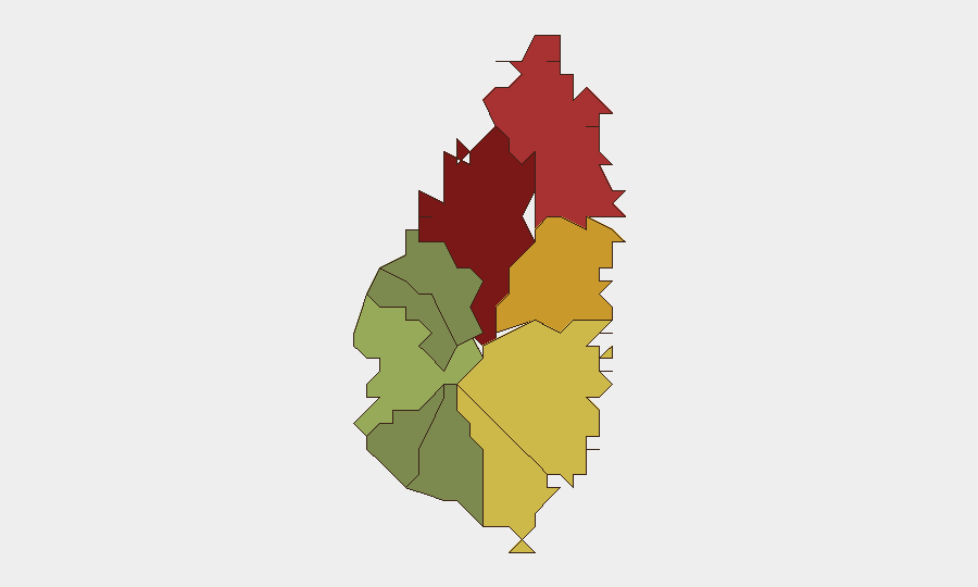
Castries dominates the national risk calculation (95/100) and is the clear operational and administrative nexus of current tension, hosting multiple governance investigations, demonstrations, and police activity simultaneously. Gros Islet (78) and Dennery (72) show secondary but significant exposure, likely reflecting spillover from capital-area political activity or localized labour and administrative issues. The sharp risk gradient from Castries through Gros Islet and Dennery—compared to substantially lower scores in peripheral districts (Canaries: 12)—indicates that threats and duty-of-care concerns are concentrated in the northern and central urban corridor. Teams with assets or personnel outside this corridor face materially lower exposure; those in or transiting Castries should treat elevated vigilance as standard practice.
How GeoBit Would Assist
Intel Sweep and X/Twitter & Telegram OSINT would provide real-time corroboration of the governance and labour signals flagged above, capturing local political discourse and official statements missed by mainstream media. AOI Monitoring & Early Warning pinned to Castries and Gros Islet would detect escalation in protests, police activity, or political rhetoric within 2–4 hours of occurrence. Entity extraction and Network & Actor Analysis would map relationships among the Governor, Legislature, Deputy officials, and labour organisations, clarifying which actors are aligned and where flashpoints may emerge.
7-Day Outlook
Near-term trajectory is likely to see continued investigative activity and potential follow-up detentions or administrative actions as governance bodies pursue their inquiries. Labour mobilisation in Castries may persist or broaden if grievances remain unaddressed. The absence of violence signals to date suggests political/administrative channels are (so far) containing tensions, but the velocity of multiple simultaneous events warrants assumption of further developments within 5–7 days.
Highest-Risk Areas — Ranked
| # | State / Region | Risk |
|---|---|---|
| 1 | Castries | 95 |
| 2 | Gros Islet | 78 |
| 3 | Dennery | 72 |
| 4 | Vieux Fort | 68 |
| 5 | Micoud | 65 |
| 6 | Soufrière | 42 |
| 7 | Laborie | 38 |
| 8 | Choiseul | 35 |
| 9 | Anse La Raye | 28 |
| 10 | Canaries | 12 |
Previous Daily Briefs
A new Saint Lucia brief is written every day — each with its own risk map and downloadable CSV. Here's the last week; use the calendar to go further back.
📅 Browse every day by calendar →
Highlighted days have a brief. Tap a day for that day's map & analysis, or “csv” for that day's dataset ($5).