Situation Summary
Samoa's security environment remains stable with no verified new incidents detected in the last 24–48 hours. Government activity is focused on economic policy, national development strategy implementation, and routine regional engagement, with no reports of civil unrest, political violence, or infrastructure disruption. The single tracked event (a physical assault on 2026-06-10) does not indicate systemic instability. Overall threat posture is low, though sub-national variation warrants targeted geographic awareness.
Key Developments
- Samoa (National), 2026-06-10: One physical assault incident recorded; categorized as indigenous-related. No escalation, secondary incidents, or broader conflict indicators reported in follow-up coverage.
- Apia (Capital Region), last 48h: Launch of the Samoa 2026–2031 national development strategy proceeded without disruption. Ceremonial events and governance discussions dominated official communications; no security incidents or demonstrations noted.
- Samoa (National), last 48h: Government and diplomatic messaging emphasizes economic development pathways, IMF assessments, and policy continuity. Focus on institutional planning rather than crisis response or emergency declarations.
- Samoa (National), last 48h: Continued participation in regional cooperation forums (Pacific women leaders' initiatives, child wellbeing programs) reflects political stability and uninterrupted external engagement.
- Samoa (National), last 48h: Government partnership communications with Australia and other allies remain routine; no security alerts or diplomatic incidents reported.
- Samoa (National), last 48h: International institutional engagement (e.g., UN disability rights committee participation) ongoing without interruption, indicating institutional continuity.
- American Samoa (Regional context), last 48h: U.S. appropriations for American Samoa treated as routine budgetary matter; no regional security shocks or cross-territorial incidents reported.
Highest-Risk Areas
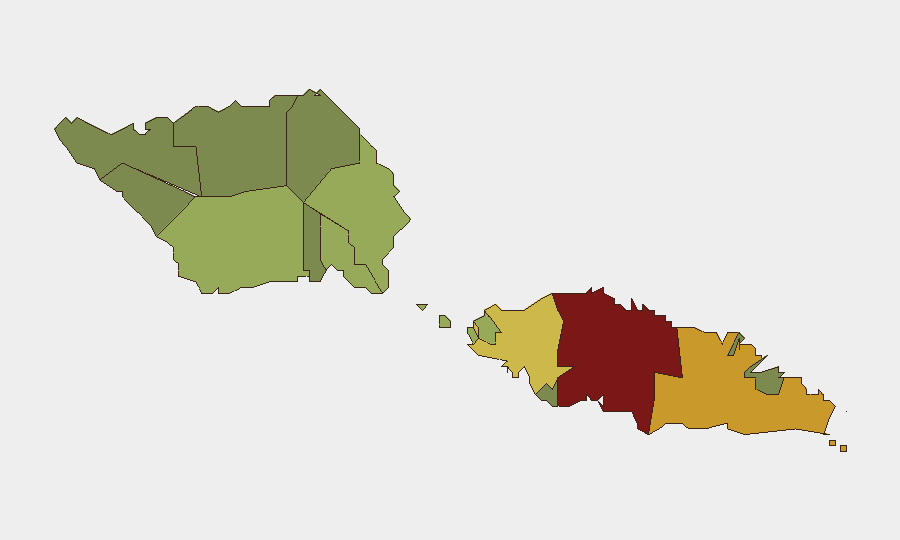
Tuamasaga (risk 85) and Ātua (risk 71) are significantly elevated compared to other districts, likely reflecting Apia's concentration of government, commercial, and diplomatic activity, combined with higher population density and urbanization. Aʻana (risk 62) and Aiga-i-le-Tai (risk 55) remain moderately elevated. The coastal and capital-proximate districts drive composite risk; rural and outer districts (Vaʻa-o-Fonoti, Vaisigano, Gagaʻifomauga) register substantially lower scores. Risk drivers in high-scoring areas typically reflect organized-crime vulnerability, intercommunal tensions, and crime-of-opportunity rather than political instability or armed conflict.
How GeoBit Would Assist
Security and risk teams should employ AOI Monitoring & Early Warning on Tuamasaga and Ātua to detect emerging incidents, civil unrest, or crime spikes before they affect corporate operations or personnel safety. OSINT fusion & corroboration (cross-referencing government channels, local media, social signals, and diplomatic feeds) will provide rapid verification of any new incidents and reduce false-positive risk. Routing & Network Analysis supports alternative journey planning for personnel transiting high-risk districts, particularly around Apia during peak commercial or ceremonial activity.
7-Day Outlook
No acute security deterioration is forecast over the coming week. Government economic and development initiatives are expected to continue without disruption. Baseline vigilance on inter-community relations and routine crime prevention remains appropriate; the single recent assault does not signal an emerging trend. Personnel and asset security posture should remain standard for a low-threat environment, with heightened awareness in Tuamasaga district.
Highest-Risk Areas — Ranked
| # | State / Region | Risk |
|---|---|---|
| 1 | Tuamasaga | 85 |
| 2 | Ātua | 71 |
| 3 | Aʻana | 62 |
| 4 | Aiga-i-le-Tai | 55 |
| 5 | Faʻasaleleaga | 48 |
| 6 | Palauli | 42 |
| 7 | Satupaʻitea | 38 |
| 8 | Gagaʻemauga | 35 |
| 9 | Gagaʻifomauga | 32 |
| 10 | Vaisigano | 28 |
| 11 | Vaʻa-o-Fonoti | 23 |
Sources
Previous Daily Briefs
A new Samoa brief is written every day — each with its own risk map and downloadable CSV. Here's the last week; use the calendar to go further back.
📅 Browse every day by calendar →
Highlighted days have a brief. Tap a day for that day's map & analysis, or “csv” for that day's dataset ($5).