Résumé de la situation
Les Samoa restent un environnement à faible menace avec un score de menace composite de 44 et aucun incident vérifié de conflit, troubles civils, criminalité majeure ou défaillance d'infrastructures au cours des 24 à 48 dernières heures. Le tableau de sécurité est stable sur toutes les principales îles, et les services gouvernementaux et publics fonctionnent normalement. Le risque à court terme est concentré à Tuamasaga (le district de la capitale d'Upolu), qui représente la majorité du score de menace composite du pays ; cependant, les rapports actuels de sources ouvertes n'indiquent aucun déclencheur immédiat ou facteur d'escalade.
Évolutions clés
- Niveau national, 17 juin – Le Centre national des opérations d'urgence des Samoa a confirmé les réserves de carburant à environ 42 jours de diesel, 48 jours d'essence et 82 jours de carburant pour réacteurs. Un avis de niveau ambre reste en place à titre préventif ; aucune pénurie de carburant, rationnement ou interruption de service n'a été signalé, et aucune agitation civile n'a été rapportée.
- Aéroport international de Faleolo, Upolu, mi-juin – Une interruption temporaire de l'électricité basse tension a affecté le terminal de l'aéroport ; le courant a été entièrement rétabli et toutes les opérations aéroportuaires sont revenues à la normale. Aucun impact sur la sécurité, la sûreté ou les plannings de vol n'a été signalé.
- Niveau national, 17 juin – Le Secrétariat de presse du gouvernement a noté que deux ressortissants samoas sont en détention au Viêt Nam dans le cadre d'une enquête pour meurtre à l'étranger. Aucune représaille interne, protestation ou incident de sécurité n'a été lié à cette affaire judiciaire externe aux Samoa.
- Apia et îles principales, 17–18 juin – Les activités gouvernementales et publiques à Upolu et Savai'i se poursuivent sans désordre ni incident perturbant l'ordre public. Aucune nouvelle augmentation de la criminalité, perturbation du trafic ou défaillance d'infrastructures n'est rapportée.
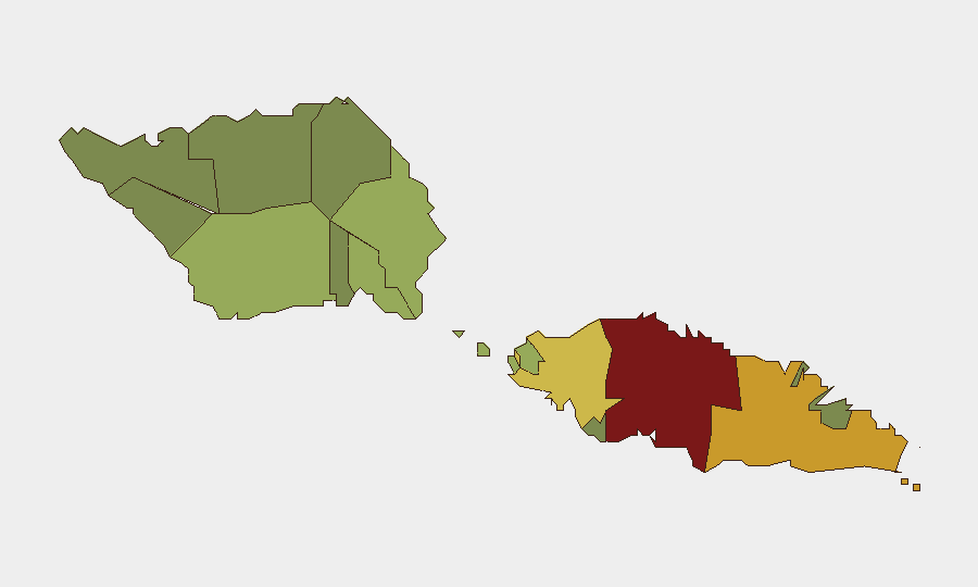
Zones à risque maximal
Le district de Tuamasaga (score de risque 85) domine le profil de menace composite des Samoa et mérite une surveillance prioritaire ; il englobe Apia, la capitale, où se concentrent les infrastructures gouvernementales, commerciales et portuaires. Ātua (71) et Aʻana (62) suivent comme zones de préoccupation secondaire. Ces classements reflètent probablement l'urbanisation, la densité de population et les taux de criminalité de base plutôt qu'un conflit ou une instabilité immédiate ; les rapports actuels confirment aucun incident actif dans ces districts. Les districts à risque plus faible (Vaisigano, Vaʻa-o-Fonoti) affichent une exposition considérablement réduite et ne contribuent pas matériellement au score de menace national.
Comment GeoBit pourrait aider
Les équipes de sécurité d'entreprise et de devoir de diligence devraient utiliser la capacité AOI Monitoring & Early Warning de GeoBit pour maintenir une surveillance persistante sur Tuamasaga (en particulier les installations portuaires, aéroportuaires et gouvernementales) avec alertes en temps réel sur les troubles civils, l'action syndicale ou l'escalade criminelle. L'analyse de fusion OSINT et des réseaux sociaux multilingues (X, Telegram, actualités locales) permettent la détection rapide des tensions politiques émergentes ou des changements de sentiment public qui pourraient précéder des incidents formels. Pour le routage de la chaîne d'approvisionnement et du personnel, l'analyse du routage et du réseau combinée à la surveillance économique et commerciale soutient la planification des contingences autour des perturbations de carburant et de navigation.
Perspective pour 7 jours
Aucune escalade matérielle n'est anticipée à l'horizon de sept jours en l'absence de chocs externes (par exemple, événements géopolitiques régionaux, catastrophe naturelle majeure ou action syndicale imprévue). L'avis de carburant préventif devrait rester en place durant la programmation normale des livraisons de carburant ; aucune crise d'approvisionnement immédiate n'est prévue. La surveillance devrait rester concentrée sur Tuamasaga et la surveillance OSINT soutenue des changements de sentiment ou des frictions politiques.
Zones les Plus à Risque — Classées
| # | État / Région | Risque |
|---|---|---|
| 1 | Tuamasaga | 85 |
| 2 | Ātua | 71 |
| 3 | Aʻana | 62 |
| 4 | Aiga-i-le-Tai | 55 |
| 5 | Faʻasaleleaga | 48 |
| 6 | Palauli | 42 |
| 7 | Satupaʻitea | 38 |
| 8 | Gagaʻemauga | 35 |
| 9 | Gagaʻifomauga | 32 |
| 10 | Vaisigano | 28 |
| 11 | Vaʻa-o-Fonoti | 23 |
Sources
Bulletins Quotidiens Précédents
Un nouveau bulletin Samoa est publié chaque jour — chacun avec sa carte de risque et son CSV téléchargeable. Voici la dernière semaine ; utilisez le calendrier pour remonter plus loin.
📅 Browse every day by calendar →
Highlighted days have a brief. Tap a day for that day's map & analysis, or “csv” for that day's dataset ($5).