Situation Summary
San Marino remains one of Europe's lowest-risk jurisdictions, with no credible security incidents, civil unrest, infrastructure disruptions, or elevated threat activity reported in the last 24–48 hours. Open-source monitoring across news wires, advisory databases, and regional media confirms unchanged baseline conditions. The country's composite threat score and absence of tracked security events reflect its characteristically stable political and law-enforcement environment.
Key Developments
No discrete security, conflict, crime, or infrastructure events have been reported in San Marino during 22–23 June 2026. Routine administrative and regulatory references to the country in international databases carry no associated security incident or advisory update. No new travel warnings, civil unrest alerts, politically motivated violence reports, or natural-disaster notices have been issued by major government foreign-travel advisory sources in this window.
Highest-Risk Areas
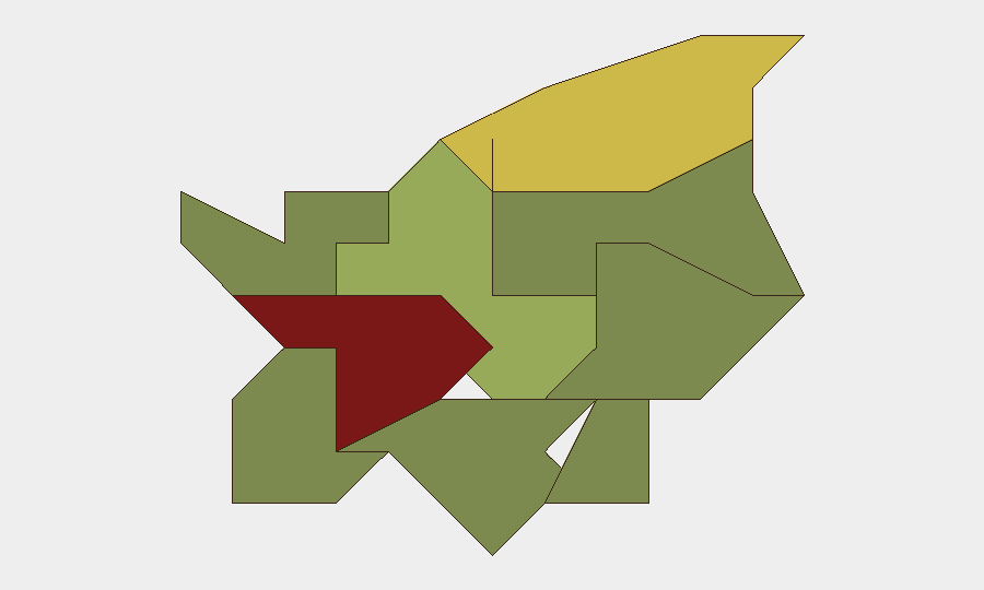
Città di San Marino (capital; risk score 85) and Serravalle (risk score 68) account for the majority of the country's composite risk profile, reflecting their concentration of population, commerce, tourism infrastructure, and administrative density. These urban centers naturally carry greater exposure to petty crime, crowd-management considerations, and cross-border facilitation with Italy than rural areas. The remaining castelli (Borgo Maggiore, Fiorentino, Domagnano, and smaller municipalities) register substantially lower risk scores, consistent with lower population density and tourism throughput. Overall risk levels across all sub-national units remain well below European averages for theft, violence, and civil disruption.
How GeoBit Would Assist
Organizations with personnel or assets in San Marino can deploy AOI Monitoring & Early Warning on Città di San Marino and Serravalle to detect emerging protests, security incidents, or infrastructure disruptions in real time, with alerts configured for political activity, crime spikes, or cross-border anomalies. Intel Sweep and multi-language OSINT (news, social media, Telegram) provide continuous baseline monitoring of Italian-language security reporting and regional political developments that may affect San Marino's stability. GIS & Spatial Analysis and Routing & Network Analysis support duty-of-care teams in identifying safe movement corridors and emergency-response infrastructure in the event of unexpected disruptions, and can model alternative routing to/from Italy in crisis scenarios.
7-Day Outlook
No indicators suggest material change to San Marino's security posture over the next seven days. Baseline conditions—low crime, political stability, functional governance, and unrestricted travel—are expected to persist. Ongoing monitoring of Italian regional developments (particularly in Emilia-Romagna) and periodic review of border-crossing status remain routine precautions but do not indicate elevated near-term risk.
Highest-Risk Areas — Ranked
| # | State / Region | Risk |
|---|---|---|
| 1 | Città di San Marino | 85 |
| 2 | Serravalle | 68 |
| 3 | Borgo Maggiore | 52 |
| 4 | Fiorentino | 32 |
| 5 | Domagnano | 28 |
| 6 | Faetano | 22 |
| 7 | Chiesanuova | 18 |
| 8 | Montegiardino | 16 |
| 9 | Acquaviva | 15 |
Previous Daily Briefs
A new San Marino brief is written every day — each with its own risk map and downloadable CSV. Here's the last week; use the calendar to go further back.
📅 Browse every day by calendar →
Highlighted days have a brief. Tap a day for that day's map & analysis, or “csv” for that day's dataset ($5).