Situation Summary
Solomon Islands remains stable overall, with no acute security incidents, civil unrest, or infrastructure disruption reported in the last 24–48 hours. Risk is concentrated in routine urban crime and gang activity, particularly in Honiara and Guadalcanal Province, rather than in active conflict or political crisis. A magnitude 4.7 earthquake struck 132 km northwest of Malango on 13 June, but caused no reported damage or tsunami threat. Parliamentary security operations are ongoing as a precautionary measure, aligned with normal governance activity.
Key Developments
- Honiara & Guadalcanal / 11–12 June — No new security incidents or civil unrest reported; the environment remains operationally stable, with risk profile consistent with baseline urban crime patterns rather than acute threat escalation.
- National transport nodes / 11–12 June — Airport, seaport, and road networks continue normal operations; no travel disruption, curfews, or emergency restrictions in effect.
- Malango seismic zone / 13 June — Magnitude 4.7 earthquake recorded 132 km northwest of Malango; no damage assessment or tsunami warning issued, indicating minimal disruptive impact.
- Parliamentary security operations / 11–12 June — RSIPF conducted stepped-up security deployments linked to parliamentary business; characterized as precautionary rather than responsive to an identified threat.
- Diplomatic engagement / 11–12 June — Government statements focused on travel-access discussions with Australia and New Zealand; no indicators of political instability or external security pressure reported.
- No nationwide emergency declarations — Monitoring across all provinces found no reports of states of emergency, curfews, or major administrative disruption during the review period.
Highest-Risk Areas
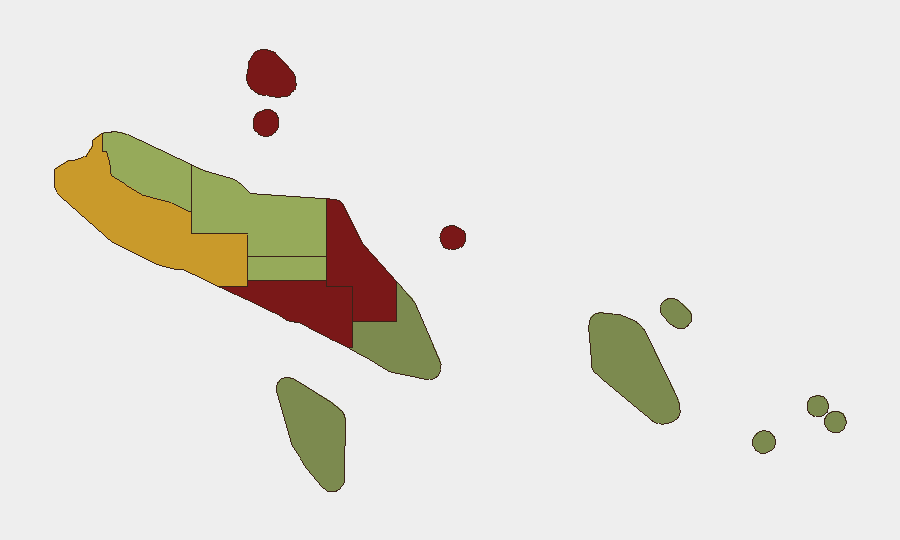
Honiara (risk 92) and Guadalcanal Province (risk 88) drive the country's composite threat score, followed by Malaita (risk 85). Risk in these three provinces stems from endemic gang activity, interpersonal violence, robbery, and property crime rather than organized terrorism or political upheaval. Honiara, as the capital and largest urban centre, concentrates both population density and criminal opportunity. Western Province (risk 72) presents elevated but secondary risk. The outer provinces—Temotu, Rennell and Bellona, and Makira-Ulawa—remain substantially lower-risk, reflecting lower population density and reduced criminal activity.
How GeoBit Would Assist
Teams with personnel or assets in Solomon Islands should deploy AOI Monitoring & Early Warning to watch Honiara and Guadalcanal for signs of escalation in gang violence or civil unrest, with alerting on new incident reports. OSINT Fusion (X/Twitter, local media, government announcements) provides daily cross-source validation of stability claims and identifies emerging political or social friction before it reaches critical mass. Risk & Threat Assessment combined with Routing & Network Analysis helps security teams plan safe movement corridors and identify alternative access routes in the event of localized disruption in high-risk zones.
7-Day Outlook
No acute deterioration is anticipated in the near term. Routine crime risk will persist in urban areas, particularly Honiara, and should remain the primary focus of duty-of-care planning. Seismic activity in the region warrants continued monitoring for aftershocks and any secondary infrastructure impact, though the 13 June event produced no significant consequences.
Highest-Risk Areas — Ranked
| # | State / Region | Risk |
|---|---|---|
| 1 | Honiara | 92 |
| 2 | Guadalcanal | 88 |
| 3 | Malaita | 85 |
| 4 | Western | 72 |
| 5 | Choiseul | 58 |
| 6 | Isabel | 52 |
| 7 | Central Province | 48 |
| 8 | Makira-Ulawa | 38 |
| 9 | Rennell and Bellona | 22 |
| 10 | Temotu | 18 |
Previous Daily Briefs
A new Solomon Islands brief is written every day — each with its own risk map and downloadable CSV. Here's the last week; use the calendar to go further back.
📅 Browse every day by calendar →
Highlighted days have a brief. Tap a day for that day's map & analysis, or “csv” for that day's dataset ($5).