Situation Summary
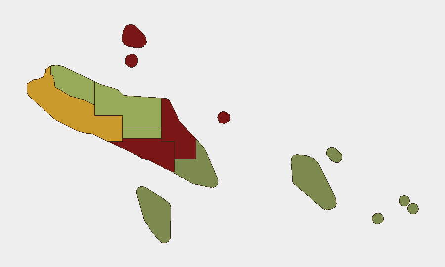
Solomon Islands remains a low-frequency security environment globally (rank #155, composite threat score 9) with no tracked security incidents during the analysis period. However, sub-national risk concentration in the capital and surrounding regions—particularly Honiara (risk 92) and Guadalcanal (risk 88)—reflects persistent localized vulnerabilities in urban crime, infrastructure brittleness, and maritime safety. The broader archipelago presents fragmented risk patterns, with outer provinces substantially lower-threat. Overall trajectory remains stable absent new destabilizing events.
Key Developments
- Between Tikopia and Vanikoro, Temotu Province — 14 October 2026: RSIPV *Gizo* and supporting vessels completed rescue of 73 people (including 15 crew) from the inter-island ferry MV *Awka*, which suffered total engine failure on 9 October and drifted for three days at sea. Passengers were safely disembarked at Vanikoro and Lata; incident and rescue were confirmed by Solomon Islands Government and Government Services Portal.
No other security-related developments (conflict, civil unrest, terrorism, organized crime, political instability, or travel impediments) were substantiated by available open-source reporting or social-media corroboration during 14–20 October 2026.
Highest-Risk Areas
Honiara and Guadalcanal Province together account for the country's highest composite risk scores (92 and 88 respectively), driven primarily by urban crime concentration, informal-settlement volatility, gang activity, and limited state law-enforcement capacity. Malaita (risk 85) follows as a secondary concern, reflecting historical communal tensions and inter-island resource competition. The Western, Choiseul, and Isabel provinces show moderate risk (72, 58, and 52), while outer islands (Temotu, Rennell and Bellona, Makira-Ulawa) present substantially lower threat profiles. Risk is heavily skewed toward the capital region and central archipelago; corporate and expatriate personnel and assets should calibrate presence and movement protocols accordingly.
How GeoBit Would Assist
Security teams should deploy AOI Monitoring & Early Warning on Honiara and Guadalcanal to detect emerging crime trends, protest activity, or maritime incidents with persistent alerting. Maritime & Aviation Tracking and Alternative Route/Journey Planning capabilities enable real-time vessel and transport monitoring—critical for the inter-island ferry network demonstrated vulnerable during the MV *Awka* incident. OSINT fusion (X/Twitter, Telegram, local media, and government service feeds) supports continuous low-frequency threat monitoring and corroboration of emerging political or security shifts that may not yet register in formal reporting.
7-Day Outlook
No acute security deterioration is anticipated during the near term absent external shocks (regional maritime incidents, climate events, or political triggering). Routine urban crime and infrastructure fragility in Honiara and Guadalcanal will remain the primary duty-of-care drivers for corporate operations. Continued monitoring of inter-island maritime safety protocols is warranted given the demonstrated vulnerability of aging ferry fleets to mechanical failure and extended rescue dependencies.
Highest-Risk Areas — Ranked
| # | State / Region | Risk |
|---|---|---|
| 1 | Honiara | 92 |
| 2 | Guadalcanal | 88 |
| 3 | Malaita | 85 |
| 4 | Western | 72 |
| 5 | Choiseul | 58 |
| 6 | Isabel | 52 |
| 7 | Central Province | 48 |
| 8 | Makira-Ulawa | 38 |
| 9 | Rennell and Bellona | 22 |
| 10 | Temotu | 18 |
Sources
Previous Weekly Briefs
A new Solomon Islands brief is written every Monday, covering the week — each with its own risk map and downloadable CSV. Use the calendar to go further back.
- October 13, 2026
- October 6, 2026
- September 29, 2026
- September 22, 2026
- September 15, 2026
- September 8, 2026
- September 2, 2026
📅 Browse past briefs by calendar →
Highlighted days have a brief. Tap a day for that day's map & analysis, or “csv” for that day's dataset ($5).
Atlas — our AI intelligence desk — emails them this snapshot personally. Nothing else, no list.