Situation Summary
Sudan's civil war continues to intensify across multiple fronts, with the Rapid Support Forces (RSF) consolidating territorial gains in Darfur and key strategic areas while the Sudanese Armed Forces (SAF) face sustained pressure in the capital and outlying regions. The recent RSF capture of El Fasher—the last major SAF stronghold in Darfur—marks a significant military turning point, triggering immediate humanitarian deterioration and heightened atrocity risk in the region. Concurrent siege conditions in South Kordofan, cross-border oil-field tensions, and widespread drone strikes on civilian infrastructure underscore the conflict's expansion in scope and lethality. Over 12.4 million people are now internally displaced or refugee, with famine conditions, medical system collapse, and disease outbreak risk creating a cascading humanitarian emergency that will constrain operations and increase duty-of-care exposure for organizations with personnel in-country.
Key Developments
- El Fasher (North Darfur), 2026-06-02–03: RSF confirmed in control of the city; UN reporting widespread looting, aid obstruction, and acute civilian-protection risk. Medical and water infrastructure severely compromised.
- Khartoum (capital), ongoing: Street battles and shelling between SAF and RSF continue across multiple districts with incoming fire striking residential areas; civilian casualties and new internal displacement reported daily.
- Kadugli & Dilling (South Kordofan), recent: Siege tightening with shelling and drone strikes blocking aid and movement; acute shortages of food, fuel, and medical supplies for trapped civilian populations.
- Babanuusa & Heglig oil field (West/South Kordofan border), ongoing: RSF consolidation of oil infrastructure has triggered South Sudanese force deployments on the Sudan side of the border, raising cross-border military tension and infrastructure-security risk.
- Catila (South Darfur) & Kutum (North Darfur), 2026-06-03: Indiscriminate drone strikes killed 30+ civilians in Catila; pattern of aerial attack escalation by both parties across Darfur documented.
- Health-sector attacks (nationwide), January–June 2026: WHO confirms 65+ verified attacks on health facilities; 1,600+ killed, 276 injured; medical capacity severely degraded in all conflict zones.
- Abyei (UNISFA sector), recent: Drone strike killed six Bangladeshi UN peacekeepers and wounded nine, confirming elevated threat to international personnel and critical-mission movement.
- Displacement & famine (nationwide): 12.4 million internally displaced; 3.3 million refugees in neighboring states; famine conditions and disease outbreaks accelerating across major hubs (Khartoum, Gezira, Darfur).
Highest-Risk Areas
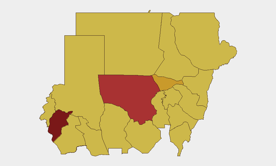
Central Darfur State (risk 100) and North Kordofan State (78.8) remain the epicenter of active warfare, atrocity risk, and humanitarian collapse, driven by RSF territorial consolidation and SAF defensive operations. Al Khartum (72.5) sustains the highest risk in an urban setting due to ongoing street combat, shelling of civilian areas, and the critical vulnerability of capital-city infrastructure and displaced populations. The tier-two cluster—River Nile, Blue Nile, Aj Jazira, Red Sea, and Kassala states (all 70)—reflects secondary conflict spread, siege conditions, and supply-chain disruption that amplifies displacement and disease risk across the country's breadth. South Darfur, West Kordofan, and Sennar states (70) round out the critical-risk belt, indicating that armed-group activity and humanitarian exposure now span Sudan's geographic extent rather than remaining localized.
How GeoBit Would Assist
Organizations with personnel or supply chains in Sudan should deploy AOI (Area-of-Interest) Monitoring & Early Warning on Khartoum, Darfur, and South Kordofan to detect real-time conflict movement, shelling activity, and checkpoint/access-denial changes. Battle mapping and force-structure tracking would enable security teams to distinguish between SAF and RSF positions, anticipate front-line shifts, and inform evacuation or relocation timing. Routing & Network Analysis can identify safe corridors and alternative supply routes around active fighting zones, while Intel Sweep and multi-language OSINT on healthcare attacks, displacement flows, and disease outbreak signals provide early warning of secondary risk (medical collapse, epidemic spread) that multiplies duty-of-care liability.
7-Day Outlook
RSF territorial consolidation in Darfur and the oil belt is likely to continue, with SAF mounting defensive operations that will sustain or increase urban combat intensity in Khartoum and secondary towns. Humanitarian access restrictions, drone-strike escalation, and siege tightening in South Kordofan will accelerate medical and food-security deterioration, raising evacuation pressure and medical-emergency risk for foreign nationals and their dependents. Cross-border tensions over oil infrastructure may trigger localized flare-ups along the Sudan–South Sudan border.
Highest-Risk Areas — Ranked
| # | State / Region | Risk |
|---|---|---|
| 1 | Central Darfur State | 100 |
| 2 | North Kordofan State | 78.8 |
| 3 | Al Khartum | 72.5 |
| 4 | River Nile State | 70.4 |
| 5 | Blue Nile | 70 |
| 6 | Aj Jazira | 70 |
| 7 | Red Sea State | 70 |
| 8 | Al Qadarif State | 70 |
| 9 | Kassala State | 70 |
| 10 | Sennar State | 70 |
| 11 | South Darfur State | 70 |
| 12 | West Kurdufan State | 70 |
Previous Daily Briefs
A new Sudan brief is written every day — each with its own risk map and downloadable CSV. Here's the last week; use the calendar to go further back.
📅 Browse every day by calendar →
Highlighted days have a brief. Tap a day for that day's map & analysis, or “csv” for that day's dataset ($5).