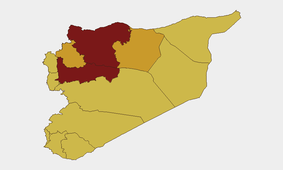
Situation Summary
Syria remains in active civil conflict with fragmented state authority, persistent ISIS insurgency, and cross-border military activity driving an overall threat composite score of 100 globally. The past 72 hours show sustained kinetic operations across eastern and southern regions, along with documented human rights violations, displacement, and militia interference in civilian spaces. The security picture is deteriorating in the south (Suwayda, Daraa, Quneitra), where armed actors impersonating official forces, ISIS sleeper cells, and Israeli cross-border operations create compounding risks for residents and foreign nationals.
Key Developments
- Deir ez-Zor countryside (east) – ISIS executed coordinated multi-site attacks on SDF checkpoints, vehicles, and military posts, demonstrating sustained insurgent operational capability; SDF simultaneously arrested a senior ISIS emir in a Global Coalition joint operation, indicating mixed tactical outcomes.
- Suwayda Governorate (south) – Armed militants in Syrian Army and General Security uniforms, some bearing ISIS insignia, conducted home raid and executed a U.S. citizen (Hussam Saraya), signaling critical impersonation/uniform penetration risks and actor-profile complexity.
- Southern Syria displacement (Daraa/Quneitra/Suwayda) – UN reported ~176,000 internally displaced persons from southern regions, reflecting rapid deterioration in security and humanitarian conditions across the zone.
- Quneitra Governorate (southwest border) – Israeli ground forces conducted a ~60-minute incursion into Quneitra territory and withdrew, continuing pattern of cross-border kinetic activity near the Golan frontier.
- Rural Daraa (south) – Israeli forces shot and wounded a civilian shepherd, documenting ongoing Israeli military operations affecting civilian populations in border-adjacent areas.
- Suwayda (south) – Local "Hijri" militias actively prevented students from sitting exams, demonstrating direct militia interference in civilian education and coercive local control.
- Daraa girls' school (south) – ISIS propaganda slogans discovered on school wall, indicating sleeper-cell intimidation tactics targeting sensitive civilian/educational infrastructure.
- Cross-border military activity (north/northeast) – Israeli aerial weapons and conventional military strikes against Syrian targets continue, paired with Syrian military responses, sustaining aerial/missile threat.
Highest-Risk Areas
Hama Governorate (risk 100) and Damascus Governorate (risk 88.1) anchor the highest-risk tier, driven by active civil conflict, security-force fragmentation, and state-control contestation. Eastern governorates—Aleppo (80), Idleb (71.2), and Ar-Raqqa (71.2)—remain ISIS insurgency strongholds where anti-SDF attacks and sleeper networks persist. The southern cluster (Daraa, Quneitra, Suwayda, Rif Dimashq; all 70 composite risk) has emerged as a critical secondary theater in the past 72 hours, combining Israeli cross-border operations, militia impersonation of state forces, ISIS sleeper propaganda, and mass displacement. Coastal governorates (Lattakia, Tartus; 70 each) maintain moderately high risk linked to regime-aligned military concentration and regional conflict spillover.
How GeoBit Would Assist
Security teams with personnel or assets in Syria should employ AOI Monitoring & Early Warning on Suwayda, Daraa, and Quneitra to detect actor movement, checkpoint establishment, and militia activity in real time. Network & Actor Analysis and entity extraction across Telegram, X, and local news feeds will identify impersonation tactics, ISIS sleeper cells, and militia command structures. Conflict & Military battle mapping, GIS & spatial analysis, and satellite imagery capabilities enable route risk assessment and checkpoint avoidance planning for personnel movement in high-threat southern zones.
7-Day Outlook
Sustained ISIS attacks on SDF positions in the east will likely continue, with counterinsurgency operations remaining episodic. Southern displacement and militia coercion are expected to intensify absent major diplomatic intervention, while Israeli cross-border kinetic activity will remain opportunistic and reactive to perceived Syrian military threat. Personnel and asset risk will remain elevated across the southern governorates and Hama/Damascus.
Highest-Risk Areas — Ranked
| # | State / Region | Risk |
|---|---|---|
| 1 | Hama Governorate | 100 |
| 2 | Damascus Governorate | 88.1 |
| 3 | Aleppo Governorate | 80 |
| 4 | Idleb Governorate | 71.2 |
| 5 | Ar-Raqqa Governorate | 71.2 |
| 6 | Lattakia Governorate | 70 |
| 7 | Tartus Governorate | 70 |
| 8 | UNDOF | 70 |
| 9 | Al-Quneitra Governorate | 70 |
| 10 | Dar'a Governorate | 70 |
| 11 | Homs Governorate | 70 |
| 12 | Rif Dimashq Governorate | 70 |
Previous Daily Briefs
A new Syria brief is written every day — each with its own risk map and downloadable CSV. Here's the last week; use the calendar to go further back.
📅 Browse every day by calendar →
Highlighted days have a brief. Tap a day for that day's map & analysis, or “csv” for that day's dataset ($5).