Situation Summary
Tanzania remains a moderate regional security concern (global rank #47) with a composite threat score of 47 across 262 tracked events. The country faces endemic risks of violent crime, civil unrest, and potential terrorist activity, particularly in urban centers and northwestern border regions. Recent travel advisories from Western nations (Germany, Spain, Australia, U.S.-aligned sources) reflect sustained concern over these threats, though no major new security incidents have been confirmed in the past 24–48 hours. Wildfire activity across multiple regions has been logged but poses primarily environmental rather than acute security risk at this stage.
Key Developments
- Nationwide – 2026-07-17 · Arrest/Detention Event: One custody/detention event logged in Tanzania on 2026-07-17; specific location and details require further corroboration from local sources.
- Multiple Regions – Ongoing Wildfire Events (recent, dates in late July 2026): Seven distinct wildfire incidents have been recorded across Tanzania (IDs: 1029426, 1029268, 1029303, 1029269, 1029182, 1029157, 1029217). While primarily environmental, wildfires can disrupt transportation, commerce, and emergency services; specific regions affected require GIS analysis to determine proximity to populated areas and asset locations.
- No Confirmed New Civil Unrest (24–48h window): Open sources do not document any fresh protest activity, roadblocks, or demonstrations in the last 24–48 hours. Earlier in July, heavy police and military deployments were observed in Dar es Salaam ahead of planned anti-government protests on 7 July 2026, which did not materialize at scale; security posture in the city remains elevated but stable as of mid-July.
Highest-Risk Areas
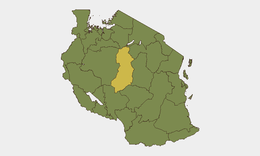
Singida Region significantly outranks all other zones, with a composite risk score of 62.8—nearly double that of the second-tier cluster. Ten regions (Kigoma, Kagera, Mwanza, Geita, Shinyanga, Tabora, Katavi, Rukwa, Songwe, Mara, and Simiyu) are clustered at identical risk scores of 32.8, indicating common underlying drivers: northwestern border proximity, limited state presence, trafficking networks, and historical communal tensions. The concentration of elevated risk in the northwest and west reflects both cross-border instability (DRC, Uganda, Zambia) and internal resource competition. Singida's elevated score warrants targeted investigation into recent criminal activity, militia presence, or localized conflict drivers not yet visible in aggregated open-source feeds.
How GeoBit Would Assist
Security teams should deploy AOI Monitoring & Early Warning on Singida Region and the secondary risk cluster to establish persistent watch with event-triggered alerting. Intel Sweep across X/Twitter, Telegram, and local Tanzanian media (with multi-language search capability) would provide granular, near-real-time coverage of unrest, arrests, and community tensions that international advisories lag in reporting. GIS & Spatial Analysis combined with Satellite & Imagery analysis would map wildfire progression and its intersection with critical infrastructure, supply routes, and personnel concentrations, enabling proactive relocation or supply-chain adjustment.
7-Day Outlook
No imminent security escalation is visible in the near-term forecast. However, the combination of elevated baseline crime and unrest risk, tight police deployments in major cities, and ongoing environmental stress (wildfires) creates conditions for rapid tactical shifts. Organizations with staff or assets in northwestern regions or Dar es Salaam should maintain heightened situational awareness and ensure communication protocols are active; no travel restrictions are warranted at this stage, but contingency planning for localized disruption remains prudent.
Highest-Risk Areas — Ranked
| # | State / Region | Risk |
|---|---|---|
| 1 | Singida Region | 62.8 |
| 2 | Kigoma Region | 32.8 |
| 3 | Kagera | 32.8 |
| 4 | Mwanza Region | 32.8 |
| 5 | Geita | 32.8 |
| 6 | Shinyanga Region | 32.8 |
| 7 | Tabora Region | 32.8 |
| 8 | Katavi Region | 32.8 |
| 9 | Rukwa Region | 32.8 |
| 10 | Songwe Region | 32.8 |
| 11 | Mara Region | 32.8 |
| 12 | Simiyu | 32.8 |
Sources
Previous Daily Briefs
A new Tanzania brief is written every day — each with its own risk map and downloadable CSV. Here's the last week; use the calendar to go further back.
📅 Browse every day by calendar →
Highlighted days have a brief. Tap a day for that day's map & analysis, or “csv” for that day's dataset ($5).
Atlas — our AI intelligence desk — emails them this snapshot personally. Nothing else, no list.