Situation Summary
Serbia remains at low composite threat (rank #95 globally, score 19), but the week of 14–20 October saw elevated law-enforcement activity tied to organized crime and weapons trafficking, alongside planned large-scale student and citizen mobilization ahead of the 25 October parliamentary election. Central Serbia continues to drive the country's risk profile (composite score 65), significantly outpacing other regions. The security environment is characterized by routine criminal investigation tempo rather than acute instability, though election-period crowd movement and pre-existing political tensions warrant continued monitoring.
Key Developments
- Nationwide (Belgrade, Novi Sad, Požarevac, Loznica, Smederevo, Kraljevo, Užice, Prokuplje, Šabac) — 14 October: Serbian police and the Security Information Agency conducted coordinated searches at over 70 locations, detaining 19 individuals in a weapons, narcotics, and document-fraud investigation; reported seizures included approximately 2.5 kg of suspected cocaine, additional drugs, cash, vehicles, and mobile phones.
- Belgrade — overnight 13–14 October: Police executed four raids resulting in seven arrests connected to suspected drug trafficking and illegal weapons possession; seizures included amphetamine, cannabis, cocaine, multiple revolvers, and 290 rounds of ammunition.
- Zaječar to Belgrade — from 16 October: A student and citizen walking column began a planned march toward Belgrade, part of pre-election mobilization scheduled to culminate in a rally on 22 October (outside this reporting period).
- Novi Sad to Belgrade — 20 October: A northern student-and-citizen walking column was scheduled to depart Novi Sad, transit through Stara Pazova, and continue toward Belgrade for the pre-election rally.
- Belgrade (Slavija Square) — announced 14 October: Student organizers published planned routes for multiple converging walking columns ahead of the 22 October pre-election rally, signaling organized mass-gathering activity in the capital.
- Air Serbia flight to Belgrade — 6 October (reference for context): A 75-year-old passenger reported mentioning a bomb aboard the aircraft, prompting evacuation of 157 passengers and six crew; incident resolved without confirmed threat.
Highest-Risk Areas
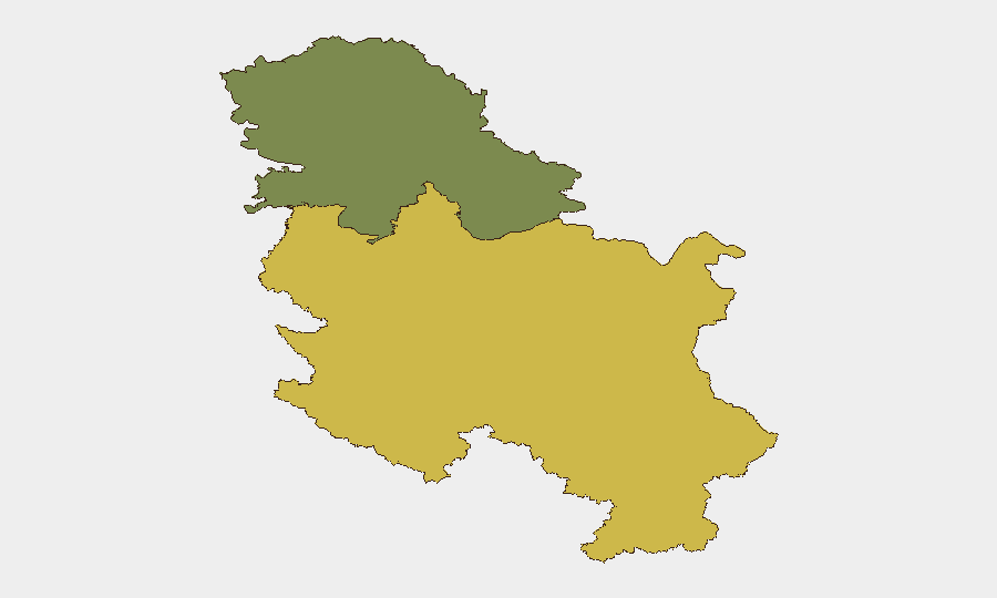
Central Serbia (composite risk score 65) substantially exceeds all other regions and anchors the country's threat ranking. The concentration of administrative, political, and economic activity in Belgrade, combined with ongoing organized-crime investigation activity and the convergence of pre-election mobilization, sustains Central Serbia's elevated profile. Vojvodina (risk score 35) presents a secondary but significantly lower risk level; although the region is experiencing student-movement activity heading into the election, no acute security incidents have been confirmed in the week under review.
How GeoBit Would Assist
Security teams with personnel or assets in Central Serbia would benefit from AOI Monitoring & Early Warning directed at Belgrade and surrounding zones to track crowd movement and election-related gatherings, combined with Intel Sweep and multi-language OSINT to detect emerging organized-crime or trafficking signals. Election Monitoring and Network & Actor Analysis capabilities would support real-time visibility into student-movement organization, rally coordination, and potential secondary security risks around 22–25 October events.
7-Day Outlook
The 22 October pre-election rally in Belgrade will likely draw large converging crowds; security services are expected to maintain visible presence. Organized-crime investigation tempo is likely to continue, with sporadic raids and arrests consistent with the past week's pattern. No acute security escalation is currently indicated for the period ahead, though mass-gathering operations and routine law-enforcement activity will warrant standard corporate duty-of-care protocols.
Highest-Risk Areas — Ranked
| # | State / Region | Risk |
|---|---|---|
| 1 | Central Serbia | 65 |
| 2 | Vojvodina | 35 |
Sources
Previous Weekly Briefs
A new Serbia brief is written every Monday, covering the week — each with its own risk map and downloadable CSV. Use the calendar to go further back.
- October 13, 2026
- October 6, 2026
- September 29, 2026
- September 22, 2026
- September 15, 2026
- September 8, 2026
- September 2, 2026
📅 Browse past briefs by calendar →
Highlighted days have a brief. Tap a day for that day's map & analysis, or “csv” for that day's dataset ($5).
Atlas — our AI intelligence desk — emails them this snapshot personally. Nothing else, no list.