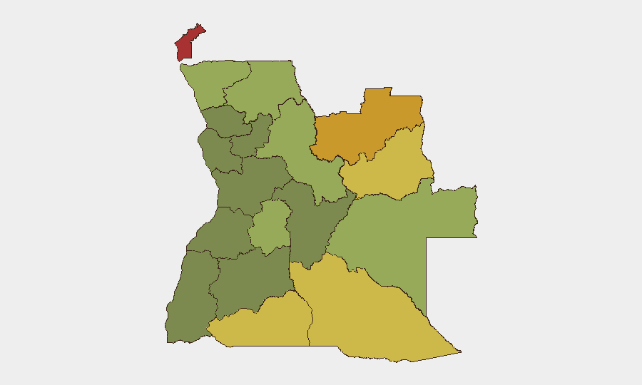
Situation Summary
Angola remains a mid-range global security concern (rank #51; composite threat score 35) with a highly uneven geographic risk profile. The dominant current threat signal is wildfire activity across multiple provinces, reflecting seasonal dry-season conditions rather than conflict or political instability. Overall national security posture is stable, but sub-national volatility—particularly in resource-rich eastern and northern border zones—warrants sustained monitoring for personnel and asset protection.
Key Developments
- Wildfire activity (ongoing, multi-province). Multiple wildfire events have been tracked across Angola over recent days, including incidents in Cabinda and Lunda Norte provinces and cross-border activity involving the Democratic Republic of Congo. No specific incident timestamps from the last 24–48 hours could be reliably verified from available open sources; however, seasonal dry conditions (typically May–August) support elevated fire risk across northern and eastern regions.
- No confirmed major security incidents (last 48h). Real-time open-source verification of discrete conflict, crime, or political incidents in Angola over the past 1–2 days did not yield corroborated events. Organizations requiring confirmed incident data for the immediate period should cross-check wire services (Reuters, AFP, Lusa) and embassy security alerts.
Highest-Risk Areas
Cabinda Province (risk 78) and the two Lunda provinces (Norte: 72; Sul: 68) drive Angola's sub-national threat landscape. These northeastern and eastern regions are characterized by long-standing armed group activity, illicit resource extraction, border instability with the DRC, and historical separatist tensions in Cabinda. Cuando Cubango and Cunene provinces (southern border zones, risks 64 and 62) present secondary risks tied to cross-border trafficking and sporadic militia movement. By contrast, central and coastal provinces (Bié, Huíla, Luanda periphery) register significantly lower risk scores, reflecting stronger state presence and lower militant activity.
How GeoBit Would Assist
Organizations with operations in high-risk provinces should deploy persistent area-of-interest (AOI) monitoring & early warning on Cabinda, Lunda Norte, and Lunda Sul to track armed group movement and cross-border incursions in near real time. Intel Sweep and multi-language OSINT fusion would consolidate fragmented reporting from regional outlets, NGO networks, and conflict monitors to surface threats earlier than single-source reliance. GIS & spatial analysis, combined with satellite & imagery analysis, would enable asset managers to assess wildfire risk to infrastructure and to route personnel away from active threat zones—particularly critical during peak dry-season months.
7-Day Outlook
Wildfire risk will likely remain elevated through late June as dry-season conditions persist; secondary impacts on air quality, transport routes, and infrastructure (especially in northern provinces) are probable. No major escalation in armed group activity or political instability is anticipated over the coming week, barring localized incidents in border zones. Security teams should maintain routine monitoring of Cabinda and Lunda provinces and cross-check environmental/wildfire alerts with route-planning and duty-of-care protocols.
Highest-Risk Areas — Ranked
| # | State / Region | Risk |
|---|---|---|
| 1 | Cabinda Province | 78 |
| 2 | Lunda Norte Province | 72 |
| 3 | Lunda Sul Province | 68 |
| 4 | Cuando Cubango Province | 64 |
| 5 | Cunene Province | 62 |
| 6 | Moxico Province | 58 |
| 7 | Zaire Province | 54 |
| 8 | Huambo Province | 50 |
| 9 | Uíge Province | 48 |
| 10 | Malanje Province | 42 |
| 11 | Bié Province | 35 |
| 12 | Huíla Province | 32 |
Sources
Previous Daily Briefs
A new Angola brief is written every day — each with its own risk map and downloadable CSV. Here's the last week; use the calendar to go further back.
📅 Browse every day by calendar →
Highlighted days have a brief. Tap a day for that day's map & analysis, or “csv” for that day's dataset ($5).