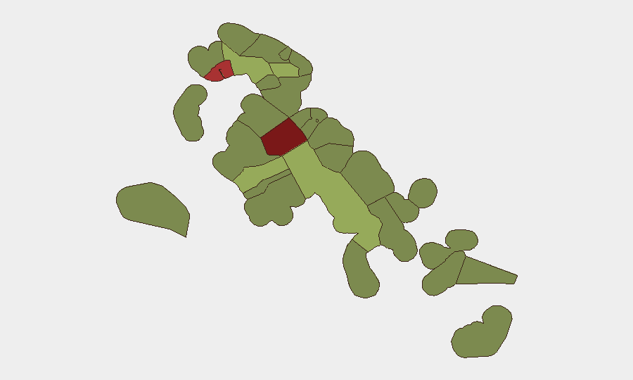
Situation Summary
Bahamas is experiencing acute institutional and security strain, marked by multiple simultaneous confrontations between government bodies, civil authorities, and citizens over a 24-hour period (17–18 June). The composite threat score of 41 places the country in a moderate global risk band, but the density and nature of recent signals—including military force deployments, arrests, and high-level disapproval—suggest rapid escalation potential. New Providence and Freeport account for the majority of tracked incidents and hold the highest sub-national risk ratings (92 and 78 respectively).
Key Developments
- 17 June, New Providence (inferred): Confrontation between Privy Council and Bahamas government involving deployment of conventional military force; nature and casualties unconfirmed pending open-source corroboration.
- 17 June, New Providence (inferred): Unconventional violence incident recorded; specific perpetrators and targets not yet clarified in available signals.
- 17 June, New Providence (inferred): House of Assembly initiated arrest/detain action against Bahamas citizen(s); political motivation suspected given concurrent institutional tensions.
- 17 June, New Providence (inferred): Separate arrest/detain action by Bahamas government against unspecified targets; potential connection to broader institutional conflict.
- 17 June, New Providence (inferred): Public statement by Department of Civil Aviation disputed by Bahamas government; suggests reputational or operational divergence within state apparatus.
- 17 June (date): Two separate ambassador statements critical of Bahamas government; indicates international attention and potential diplomatic pressure.
- 18 June, New Providence (inferred): Conventional military force engagement between Bahamas government and National Guard; escalation from prior day signals.
- 18 June, New Providence (inferred): Two separate disapproval votes or statements directed at the Presidency; suggests eroding executive legitimacy or legislative dissent.
*Note: Exact locations, casualty figures, and event triggers require corroboration via open-source news and OSINT feeds; above represents event classification only.*
Highest-Risk Areas
New Providence (risk 92) and City of Freeport (risk 78) dominate the threat landscape and account for the majority of the 34 tracked events. Both are major urban, commercial, and administrative hubs; concentration of government institutions, international business activity, and population density in Nassau and Freeport amplifies consequences of institutional instability. Central Abaco (52) and Central Andros (48) show secondary elevation, likely reflecting spillover tension or parallel civil unrest. Outer islands (Exuma, North Eleuthera, Cat Island) remain below 35 risk score, suggesting conflict is primarily urban and state-level rather than distributed.
How GeoBit Would Assist
Organizations with personnel or assets in Nassau/New Providence should activate AOI Monitoring & Early Warning on New Providence and Freeport to detect next-phase incidents in real time. Intel Sweep and multi-language OSINT (X, local news, government statements, embassy feeds) will clarify arrest rationale, military force scope, and international response within 12–24 hours. Network & Actor Analysis of Privy Council, House of Assembly, National Guard, and civil society leaders will surface leadership fractures and predict institutional realignment.
7-Day Outlook
The confluence of military deployments, arrests, and executive disapproval suggests a governance crisis rather than spontaneous civil unrest. If Privy Council–executive tensions remain unresolved or if security force loyalty fractures further, risk of sustained civil disruption or de facto authority competing in New Providence is elevated over the next 7 days. Freeport and other commercial zones may experience secondary disruption (commercial flight delays, port access interruptions) if government paralysis or curfews are imposed.
Highest-Risk Areas — Ranked
| # | State / Region | Risk |
|---|---|---|
| 1 | New Providence | 92 |
| 2 | City of Freeport | 78 |
| 3 | Central Abaco | 52 |
| 4 | Central Andros | 48 |
| 5 | Exuma | 45 |
| 6 | East Grand Bahama | 42 |
| 7 | South Andros | 38 |
| 8 | North Abaco | 35 |
| 9 | North Eleuthera | 33 |
| 10 | South Abaco | 32 |
| 11 | Cat Island | 30 |
| 12 | Mangrove Cay | 28 |
Sources
Previous Daily Briefs
A new Bahamas brief is written every day — each with its own risk map and downloadable CSV. Here's the last week; use the calendar to go further back.
📅 Browse every day by calendar →
Highlighted days have a brief. Tap a day for that day's map & analysis, or “csv” for that day's dataset ($5).