Situation Summary
Bangladesh remains a moderate-risk environment (global rank #27, composite score 67) with security pressures concentrated in urban and border areas. The India–Bangladesh frontier has become acutely tense over the past 24–48 hours, with the Border Guard Bangladesh (BGB) reporting 10 attempted "push-in" incidents by India's Border Security Force (BSF) and reciprocal claims of deportation-related standoffs. Simultaneously, recent event signals indicate administrative friction, detention activity, and civil-order incidents within Bangladesh proper, predominantly affecting Dhaka Division. The combination of border volatility and domestic administrative tension warrants elevated operational vigilance.
Key Developments
- India–Bangladesh border push-in incidents (10–11 June, multiple sectors). BGB reported foiling 10 separate attempted incursions by BSF across multiple border points within 24 hours ending 06:00 Thursday, including the Jadabpur area of Maheshpur (Jhenaidah District) and Samanta BOP. BGB has placed frontier units on highest alert with intensified patrols and intelligence surveillance.
- Stranded migrant standoff and reciprocal claims (10–11 June, Mekhliganj sector, Cooch Behar). Indian media citing BSF reported that more than 40 Bangladeshi nationals stranded at zero-point locations returned into Bangladesh within 24 hours following a standoff. BGB simultaneously claimed it foiled eight push-back attempts, indicating sustained friction over cross-border deportations and irregular-movement protocols.
- Reinforced BSF deployments near "Chicken Neck" corridor (10–11 June, Siliguri region). Enhanced security posture reported along the strategic "Chicken Neck" corridor in northern West Bengal, with tighter checks and increased monitoring of cross-border movements linked to ongoing deportation tensions.
- BGB defensive-posture strengthening (10–11 June, multiple sensitive border stretches). Social-media and regional security reporting indicates BGB has intensified patrols, tightened surveillance, and prepared defensive positions (bunkers, trenches, observation posts, heavy-weapon emplacements) across sensitive border sectors, framed as precautionary against intrusions.
- Upcoming bilateral border-issues meeting signaled (referenced 10–11 June). Bangladeshi media reports indicate Dhaka intends to raise issues of cross-border killings and push-in incidents at a scheduled bilateral meeting, reflecting intent to escalate diplomatic pressure on India over border incidents.
- Domestic administrative and detention activity (8–10 June). Recent event signals show multiple arrest/detention incidents, administrative sanctions against citizens, public statements by government, and civil-order incidents within Bangladesh, with highest concentration in Dhaka Division.
Highest-Risk Areas
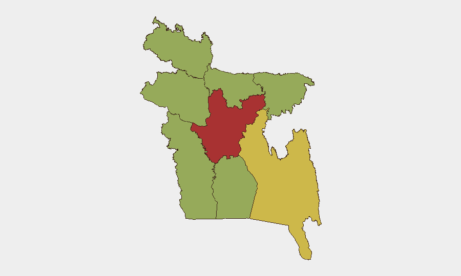
Dhaka Division (risk score 76.9) and Chittagong Division (69.2) account for the majority of tracked security incidents and represent the primary concentration of corporate and expatriate populations. Dhaka's elevated risk reflects both urban-order incidents and administrative tension; Chittagong adds port-security, organized-crime, and maritime-boundary considerations. The India–Bangladesh border belt—spanning Jhenaidah, Netrokona, and other frontier districts—has emerged as an acute flash point in the past 48 hours but is traditionally lower-density for corporate presence. Risk in secondary divisions (Barishal, Khulna, Rajshahi, Sylhet, Rangpur, Mymensingh) remains moderate and diffuse.
How GeoBit Would Assist
Teams with personnel or assets in Dhaka and Chittagong should employ GeoBit's AOI Monitoring & Early Warning capability to track administrative, civil-order, and security incidents in real time, paired with Intel Sweep and multi-language OSINT fusion to corroborate government claims, arrest announcements, and detention notices. Border & Disputed-Territory Search and Satellite & Imagery Analysis enable monitoring of the India–Bangladesh frontier for escalation patterns, deployment movements, and physical fortification changes; Network & Actor Analysis can map government, BGB, and BSF messaging to assess bilateral escalation risk.
7-Day Outlook
The India–Bangladesh border is likely to remain elevated through at least mid-June, with continued push-in and deportation claims, BGB defensive activity, and diplomatic posturing ahead of bilateral talks. Domestic administrative activity in Dhaka will require close watch but is not yet signaling systemic instability. Corporate teams should maintain elevated situational awareness and contingency protocols for both border regions and urban centers.
Highest-Risk Areas — Ranked
| # | State / Region | Risk |
|---|---|---|
| 1 | Dhaka Division | 76.9 |
| 2 | Chittagong Division | 69.2 |
| 3 | Barishal Division | 48.9 |
| 4 | Khulna Division | 47.7 |
| 5 | Rajshahi Division | 47.3 |
| 6 | Sylhet Division | 47.3 |
| 7 | Rangpur Division | 46.9 |
| 8 | Mymensingh Division | 46.9 |
Sources
Previous Daily Briefs
A new Bangladesh brief is written every day — each with its own risk map and downloadable CSV. Here's the last week; use the calendar to go further back.
📅 Browse every day by calendar →
Highlighted days have a brief. Tap a day for that day's map & analysis, or “csv” for that day's dataset ($5).