Situation Summary
Barbados remains in the lowest global threat tier (rank #88, composite score 13) with no credible indications of active security incidents, civil unrest, crime spikes, or infrastructure disruption in the past 24–48 hours. Recent event signals reflect routine political discourse (ministerial statements, legislative debate, parliamentary procedure) rather than instability or violence. Weather and marine conditions are within normal parameters. The security posture is stable with no material change to duty-of-care risk for corporate personnel or assets.
Key Developments
- 2026-07-03 · Public Statement · SURGEON vs BARBADOS – Health sector official issued statement critical of government policy; routine political discourse, no operational security impact.
- 2026-07-02 · Public Statement · CABINET – Cabinet issued public statement; standard governance communication, no indication of institutional breakdown.
- 2026-07-02 · Public Statement · SENATOR and 2026-07-02 · Public Statement · OPPOSITION SENATOR – Legislative statements reflect normal parliamentary opposition rhetoric; no evidence of civil disorder or institutional collapse.
- 2026-07-01 · Conventional Military Force · ST LUCIA – Regional naval activity noted; typical inter-island maritime operations, no escalation or threat to Barbados security posture.
- 2026-07-01 · Arrest/Detain · BARBADOS – Law enforcement activity logged; insufficient detail in available signals to assess scale or operational impact; consistent with routine criminal justice processing.
- No verified civil unrest, crime surge, or travel disruption – Open-source monitoring (news, travel advisories, weather services) shows no corroborating reports of violence, looting, protests, or infrastructure failure in the past 48 hours.
Highest-Risk Areas
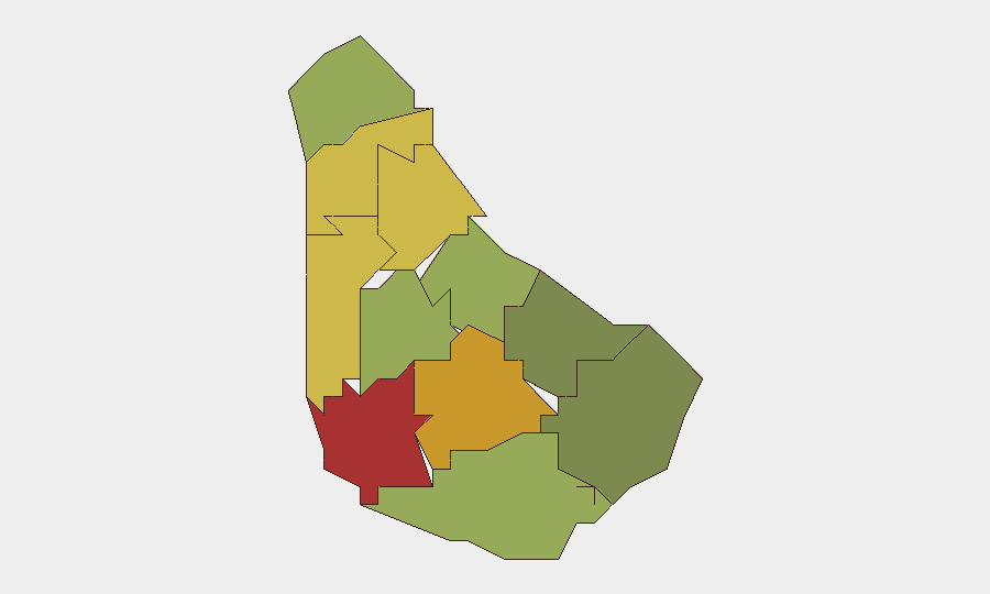
Saint Michael (risk 78) and Saint George (risk 72) dominate the sub-national ranking and likely concentrate economic assets, government functions, and population density; both merit enhanced situational awareness and personnel tracking. Saint James (risk 68) and Saint Andrew (risk 65) follow, suggesting risk is concentrated in the island's northern and western parishes. Southern parishes (Saint Philip, Saint John, Christ Church) show materially lower composite scores, indicating either lower asset density or fewer tracked threat signals. Risk concentration in the north warrants asset-owner focus on employee check-ins and route planning in those parishes during any future developments.
How GeoBit Would Assist
Security teams would deploy AOI Monitoring & Early Warning on high-risk parishes (Saint Michael, Saint George, Saint James) with persistent watch for sudden changes in public activity, gatherings, or law-enforcement response. OSINT Fusion & Corroboration (X/Twitter, Telegram, news feeds, multi-language search) would provide real-time confirmation or denial of event signals and detect grassroots sentiment shifts ahead of formal announcements. Routing & Network Analysis and Maritime & Aviation tracking would support contingency planning for personnel evacuation or re-positioning if political or security conditions deteriorate.
7-Day Outlook
Near-term outlook remains stable. Parliamentary debate and ministerial statements are likely to continue without escalation into violence or institutional breakdown. Weather patterns are normal; no cyclone or marine hazard alerts are forecast for the next 7 days. Corporate security teams should maintain standard monitoring cadence and keep personnel registries current in case rapid situational reassessment becomes necessary.
Highest-Risk Areas — Ranked
| # | State / Region | Risk |
|---|---|---|
| 1 | Saint Michael | 78 |
| 2 | Saint George | 72 |
| 3 | Saint James | 68 |
| 4 | Saint Andrew | 65 |
| 5 | Saint Peter | 62 |
| 6 | Saint Joseph | 58 |
| 7 | Saint Thomas | 52 |
| 8 | Saint Lucy | 48 |
| 9 | Christ Church | 42 |
| 10 | Saint John | 35 |
| 11 | Saint Philip | 28 |
Sources
Previous Daily Briefs
A new Barbados brief is written every day — each with its own risk map and downloadable CSV. Here's the last week; use the calendar to go further back.
📅 Browse every day by calendar →
Highlighted days have a brief. Tap a day for that day's map & analysis, or “csv” for that day's dataset ($5).