Situation Summary
Burkina Faso remains the 26th highest-threat country globally, driven by sustained jihadist insurgency that now effectively controls approximately 70% of national territory. State security forces operate with operational freedom in only ~30% of the country, while around 130 towns remain under siege, severely restricting overland commerce and travel to neighboring states. The conflict has displaced an estimated 3–5 million persons, with 229,515 newly displaced in the first five months of 2025 alone—a 92% increase year-over-year—creating deepening humanitarian stress and secondary security risks. Territorial fragmentation, heightened checkpoint activity, and documented civilian casualties from airstrikes signal a conflict environment with sustained high risk to corporate operations and personnel.
Key Developments
- NGO expulsion, Sahel region (national): Transitional authorities ordered UK-based Global Rights Compliance to leave after initiating investigation into alleged war crimes by Burkinabè forces and allied militias, reflecting acute sensitivity to external scrutiny and shrinking civic space.
- Territorial control degradation: Militant Islamist factions (primarily JNIM-linked: Maçina Liberation Front, Ansaroul Islam, Katiba Hanifa) now contest ~70% of Burkinabè territory, with state forces confined to major urban centers and ~30% of controllable ground.
- High-casualty military attacks, Eastern/Northern provinces (Di, Diapaga, Djibo, Foutouri, Lanfiera, Solenzo, Sollé, Thiou, Yamba): At least 42 attacks since early 2025 resulted in ≥10 soldier deaths per incident, concentrated on barracks and approach roads, indicating sustained combat intensity and elevated risk around security installations.
- Displacement surge, countrywide: 229,515 persons (36,826 households) newly displaced in first five months of 2025 versus 119,000 in same 2024 period; total displacement now estimated at 3–5 million, creating pressure on urban service capacity and IDP-hosting security dynamics.
- Enhanced urban security posture, Ouagadougou and national: Security ministry launched nationwide checkpoint and patrol reinforcement following Mali operations; units redeployed to capital intersections for intelligence collection on crime and terrorism.
- Civilian casualties from airstrikes, multiple locations (2023–2024): Human Rights Watch documented drone strikes on crowded markets and funeral, killing ~60 civilians, with government attribution to jihadist targeting; illustrates collateral-damage and misidentification risk in populated zones.
- Emergency law application, countrywide: General mobilization framework (April 2023) used to conscript journalists, civil-society actors, and opposition figures into security operations; restricts conflict reporting and creates legal/operational risk for local partners and information sources.
- School closures, conflict-affected areas: ~6,100 schools (~25% of national total) closed as of mid-2023, affecting ~1 million students, primarily due to jihadist attacks on educational infrastructure in rural and semi-rural zones.
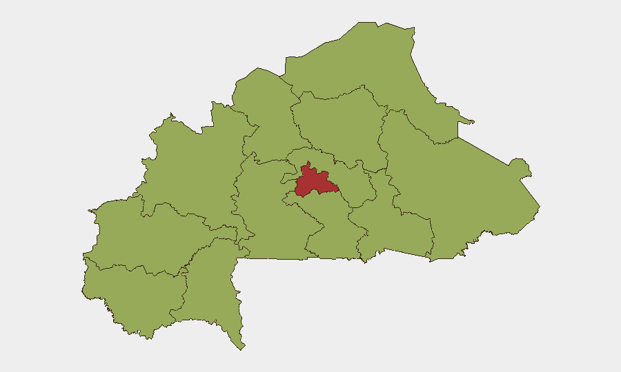
Highest-Risk Areas
Centre region (composite risk 79.6) stands significantly above all other administrative zones, reflecting proximity to Ouagadougou, high-value infrastructure, and active militant operations within the capital's hinterland. The remaining 11 tracked regions (Upper-Basins, Boucle du Mouhoun, Central-West, Central-South, Central-East, Waterfalls, Southwest, Sahel, Central-North, East, North) cluster at risk 49.6, indicating that risk is geographically distributed across the periphery; however, Eastern and Northern provinces (Di, Diapaga, Djibo) show particular operational intensity due to sustained high-casualty military engagements. Sahel region merits specific attention given jihadist territorial dominance and recent NGO expulsion. The near-equivalence of risk scores outside Centre suggests that secondary cities and inter-provincial corridors present similarly acute threats to personnel mobility and asset security.
How GeoBit Would Assist
Security teams would employ AOI Monitoring & Early Warning on high-risk administrative zones to track militant activity, checkpoint proliferation, and displacement flows in near-real time. Routing & Network Analysis would support safe-passage planning and alternative logistics corridors, particularly as territorial control shifts. OSINT fusion (X/Telegram, radio SIGINT, multi-language search) would enable continuous surveillance of jihadist communications, security-force posture, and humanitarian access constraints to inform duty-of-care decisions.
7-Day Outlook
No discrete new attack events are currently tracked in the 24-hour window, but the structural drivers—territorial fragmentation, jihadist siege of 130+ towns, and displacement pressure—remain acute. Enhanced checkpoint activity and nationalist security posture will likely persist. Personnel and logistics risk will remain elevated outside Ouagadougou and other major administrative centers; overland travel to border regions should be treated as high-risk absent real-time tactical intelligence.
Highest-Risk Areas — Ranked
| # | State / Region | Risk |
|---|---|---|
| 1 | Centre | 79.6 |
| 2 | Upper-Basins | 49.6 |
| 3 | Boucle du Mouhoun | 49.6 |
| 4 | Central-West | 49.6 |
| 5 | Central-South | 49.6 |
| 6 | Central-East | 49.6 |
| 7 | Waterfalls | 49.6 |
| 8 | Southwest | 49.6 |
| 9 | Sahel | 49.6 |
| 10 | Central-North | 49.6 |
| 11 | East | 49.6 |
| 12 | North | 49.6 |
Previous Daily Briefs
A new Burkina Faso brief is written every day — each with its own risk map and downloadable CSV. Here's the last week; use the calendar to go further back.
📅 Browse every day by calendar →
Highlighted days have a brief. Tap a day for that day's map & analysis, or “csv” for that day's dataset ($5).