Situation Summary
Cameroon remains a moderately elevated risk environment (rank #28 globally, composite score 70.7) characterized by a persistent dual-threat landscape: armed separatist conflict and IED activity in the Anglophone regions (North-West and South-West), and terrorism-linked kidnapping and displacement in the Far North bordering the Lake Chad basin. Urban crime in Yaoundé and Douala continues at high baseline levels, while civil unrest tied to political and governance tensions retains potential for rapid escalation. The security picture shows no sign of material improvement and remains structurally volatile across most sub-national zones.
Key Developments
- North-West & South-West separatist violence: Armed groups continue systematic kidnappings, illegal checkpoints, and "taxation" of civilians and vehicles; recent incident involved abduction of ~15 students from Government Bilingual High School, Kumbo (Bui Division), illustrating ongoing threat to education and movement corridors.
- IED deployment trend (NWSW): Non-state armed groups have recorded at least 131 IED incidents in 2025, concentrated in Bui and Momo divisions; pattern assessed as continuing into 2026, significantly elevating risk to convoys, security forces, and civilian traffic.
- Far North displacement and terrorism risk (Mayo-Sava, Mayo-Tsanaga, Logone-et-Chari): Lake Chad basin–linked attacks have intensified since March 2023, forcing mass displacement; UNOCHA/WFP reporting confirms sustained kidnapping and terrorism threat to civilians and cross-border travelers.
- Village-level destruction (Mbat, North-West, Feb 2026): Armed actors burned and looted Mbat on 13–14 February 2026, displacing ~850 residents and destroying hundreds of houses and farms; earlier attacks in Wowo and Gidado (Dec 2025–Jan 2026) killed ≥23 civilians, signaling escalating scale of intra-regional violence.
- Education and healthcare infrastructure disruption: 81 education-related and 20 healthcare security incidents recorded in 2025; schools and clinics remain active targets, forcing closures and restricting civilian access to essential services.
- Border zones (Nigeria, Chad, CAR): 20 km perimeter zones designated "Do Not Travel" due to terrorism, kidnapping, IEDs, and unrest; current U.S. travel advisory classifies these areas as persistent high-risk corridors.
- Urban crime baseline (Yaoundé, Douala): Violent robbery, carjacking, and petty crime remain frequent; nighttime travel and isolated areas carry elevated assault and theft risk.
- Civil unrest and protest potential (nationwide): Political tensions and Anglophone-crisis–linked grievances sustain risk of demonstrations with minimal warning; protest activity can disrupt transport and services.
Highest-Risk Areas
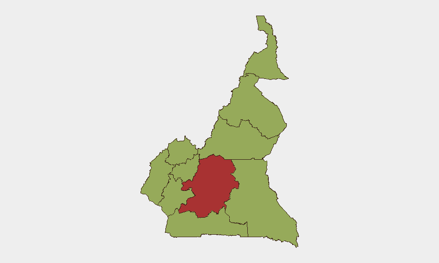
Centre region (score 79.5) dominates the risk landscape, likely reflecting security-sector activity, governance tensions, and proximity to Anglophone conflict spillover. Adamawa (55.5) follows, driven by Far North border proximity and Lake Chad basin terrorism links. The cluster of NWSW regions (scores 49.5 each) constitute the active operational epicenter of separatist violence, IED activity, and displacement. All other regions are ranked at 49.5, indicating geographically distributed baseline risk; however, the 30-point gap between Centre and secondary zones underscores that Yaoundé-area intelligence, security, and political dynamics are disproportionately shaping national threat conditions.
How GeoBit Would Assist
Security teams should employ AOI Monitoring & Early Warning to establish persistent watch over high-risk divisions (Bui, Momo, Mayo-Sava, Mayo-Tsanaga) with automated alerting for movement, violence spikes, or checkpoints. Routing & Network Analysis capabilities can generate real-time alternative journey planning for staff and supply convoys, accounting for IED incidents, roadblocks, and separatist activity zones. Conflict & Military and Network & Actor Analysis functions enable tracking of armed-group force positioning, leadership, and tactical shifts, supporting informed duty-of-care decisions on facility closure, evacuation, or staff repositioning.
7-Day Outlook
No imminent single-point escalation is flagged, but underlying conditions remain static and volatile: IED activity, kidnappings, and village attacks are recurring patterns likely to continue at current tempo. Any major political announcement, security-force operation, or international intervention statement could trigger localized protest or separatist retaliation, particularly in urban centers and NWSW zones.
Highest-Risk Areas — Ranked
| # | State / Region | Risk |
|---|---|---|
| 1 | Centre | 79.5 |
| 2 | Adamawa | 55.5 |
| 3 | Northwest | 49.5 |
| 4 | Southwest | 49.5 |
| 5 | West | 49.5 |
| 6 | Littoral | 49.5 |
| 7 | South | 49.5 |
| 8 | Far-North | 49.5 |
| 9 | North | 49.5 |
| 10 | East | 49.5 |
Sources
Previous Daily Briefs
A new Cameroon brief is written every day — each with its own risk map and downloadable CSV. Here's the last week; use the calendar to go further back.
📅 Browse every day by calendar →
Highlighted days have a brief. Tap a day for that day's map & analysis, or “csv” for that day's dataset ($5).