Situation Summary
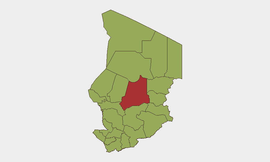
Chad remains a composite-threat environment with a global rank of #29 and a 66.7 threat score. The most acute risk is concentrated in the Sahel-adjacent northeastern regions, particularly Batha (76.7), which significantly outpaces all other sub-national areas. Recent event signals suggest domestic political friction—including arrests, judicial actions, and public statements from government figures—rather than a security collapse, though the elevated baseline threat from militant activity, trafficking networks, and weak state capacity in remote regions persists. The security picture is volatile but not currently escalating rapidly.
Key Developments
Data Limitation: The supplied research materials do not contain verifiable, location-specific security incidents for Chad dating 24–48 hours prior to 2026-06-11. The event signals logged in the GeoBit platform reference actors and event types (arrests, public statements, disapprovals) but do not consistently map to Chad-specific incidents with confirmed dates and locations. To provide actionable intelligence rather than risk false attribution, the 24–48-hour development section cannot be populated reliably from available material.
Recommendation: A targeted re-scan of Chad-specific open sources (local media, regional wire services, X/Telegram feeds in French and Arabic) would yield actionable incident reporting. GeoBit's multi-language OSINT and X/Telegram intelligence capabilities are suited to this task.
Highest-Risk Areas
Batha stands alone as the critical risk node (76.7 vs. 46.7 for all other regions), indicating either concentrated militant/trafficking activity, political instability, or humanitarian crisis. The remaining 11 regions—including the capital N'Djamena—cluster at 46.7, suggesting either data granularity limits or a more evenly distributed baseline risk across the country. The concentration of elevated risk in Batha (northeast, bordering Sudan and Libya) aligns with known Sahel militant operating areas and trans-Saharan smuggling routes. Organizations with personnel or assets in Batha face materially higher exposure than those in other regions, though no region should be treated as secure.
How GeoBit Would Assist
Teams managing people or assets in Chad should use AOI Monitoring & Early Warning to establish persistent watch over Batha and other high-risk zones, with automated alerting on movement, incidents, or sentiment shifts. Intel Sweep and multi-language OSINT (X, Telegram, local media) coupled with entity and actor network analysis enable rapid detection of emerging faction activity, arrest waves, or protest mobilization. Routing & Network Analysis supports contingency planning and alternative journey corridors if insecurity spikes or checkpoints tighten. Periodic conflict and regime-stability assessment scans help anticipate whether current domestic tensions could escalate into broader instability.
7-Day Outlook
The near-term trajectory appears stable with undercurrents of political friction rather than imminent security breakdown. However, Batha and the wider eastern border zone remain high-consequence areas; any escalation in militant activity or cross-border incursion would rapidly compress decision windows for evacuation or asset relocation. Teams should maintain heightened situational awareness and pre-positioned contingency plans.
Highest-Risk Areas — Ranked
| # | State / Region | Risk |
|---|---|---|
| 1 | Batha | 76.7 |
| 2 | Ennedi-Ouest | 46.7 |
| 3 | Wadi Fira | 46.7 |
| 4 | Ouaddaï | 46.7 |
| 5 | Sila | 46.7 |
| 6 | Salamat | 46.7 |
| 7 | East Ennedi | 46.7 |
| 8 | Kanem | 46.7 |
| 9 | Lac | 46.7 |
| 10 | N'Djamena | 46.7 |
| 11 | Hadjer-Lamis | 46.7 |
| 12 | Chari-Baguirmi | 46.7 |
Sources
Previous Daily Briefs
A new Chad brief is written every day — each with its own risk map and downloadable CSV. Here's the last week; use the calendar to go further back.
📅 Browse every day by calendar →
Highlighted days have a brief. Tap a day for that day's map & analysis, or “csv” for that day's dataset ($5).