Situation Summary
Colombia remains a composite threat environment (rank #32 globally, score 67.2) driven primarily by active insurgency, criminal trafficking networks, and politically motivated violence across fragmented territorial control zones. The past 24 hours reflect sustained operational tempo: armed clashes between state forces and FARC dissidents in Meta, reinforced military/police deployments following massacres in Cauca, and heightened activity along the Venezuela border amid regional instability. The security landscape is characterized by localized but recurring kinetic events, IED use, and coordinated attacks on state infrastructure, with political polarization and cyber-enabled influence operations adding complexity to the threat environment heading into electoral cycles.
Key Developments
- Meta Department (armed clash, 2026-06-01): Colombian Army units engaged FARC dissident "Estado Mayor Central" structures in rural Meta; multiple dissidents reported killed and weapons seized. Offensive operations against illegal armed groups remain active in central Colombia.
- Cauca Department (post-massacre response, 2026-06-01): Government expanded Army and National Police presence across rural areas following recent massacres; checkpoints and aerial surveillance deployed on key roads to counter entrenched armed-group control.
- Arauca/Venezuela Border (heightened posture, 2026-06-01): Security forces increased patrols and troop strength amid concerns that Venezuelan instability could fuel clashes between ELN, FARC dissidents, and criminal organizations in frontier zones.
- Southwestern Corridor – Cauca/Valle del Cauca (2026-06-01): Military and police leadership warned of coordinated attack threats on state targets; recent months have seen explosives and small-arms attacks on police stations and municipal infrastructure in Cali and nearby towns.
- Bogotá (political security, 2026-06-01): Defense Ministry flagged cyber operations, disinformation campaigns, and physical threats from armed groups targeting state institutions and political events; reinforced security measures deployed around government facilities.
- Catatumbo Region, Norte de Santander (2026-06-01): Sustained ELN and dissident armed-group activity constrains civilian mobility; road control, intimidation, kidnapping risk, and IED presence classified as high-threat indicators.
- National – Travel Advisories (ongoing): U.S. and U.K. advisories maintain "do not travel" warnings for Arauca, Cauca, Valle del Cauca (excluding select cities), and border zones; violent crime, kidnapping, terrorism, and landmine/IED use cited.
Highest-Risk Areas
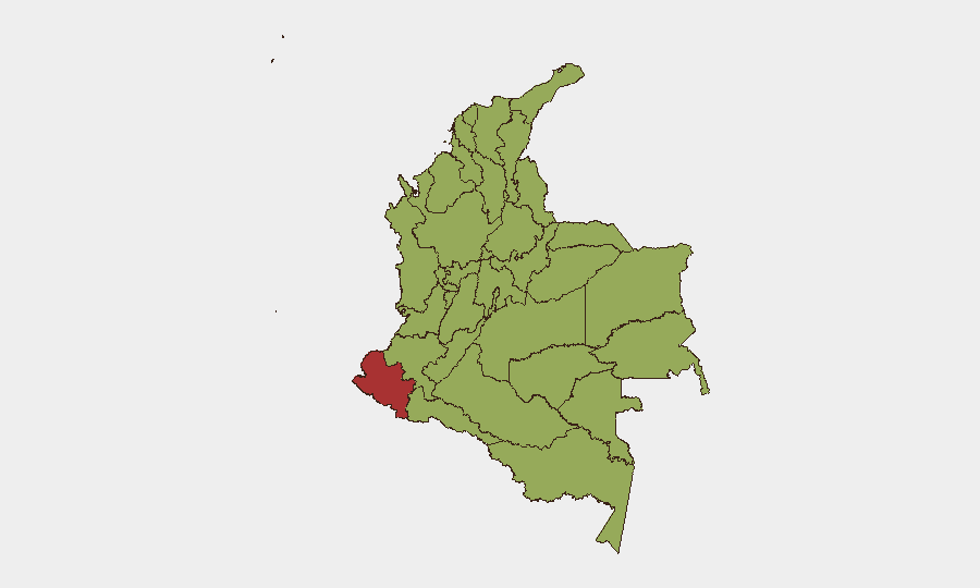
Nariño (risk 77) drives the highest composite score, followed by Meta (58.1) and Capital District Bogotá (57.8). The remaining top tier—Atlántico, Cundinamarca, Norte de Santander, Santander, Cauca, and Valle del Cauca—cluster in the 48–50 range, indicating sustained multi-vector threats across the Andean spine and border regions. Nariño's elevation reflects trafficking networks, FARC dissident presence, and porous Ecuador border dynamics; Meta's score correlates with recent kinetic activity; Bogotá's risk reflects political violence, cyber threats, and state-target focus. The geographic concentration in southwestern, central, and northern departments underscores insurgent territorial influence and trafficking-route contestation.
How GeoBit Would Assist
Security teams would leverage Intel Sweep and OSINT fusion to corroborate real-time field reporting against social-media and messaging-platform signals from armed groups and state actors. AOI Monitoring & Early Warning on Cauca, Meta, Catatumbo, and border zones would enable persistent watch and alerting on activity escalation. Network & Actor Analysis combined with conflict mapping would clarify FARC-dissident, ELN, and paramilitary force structures, intentions, and territorial claims—critical for duty-of-care routing and facility-siting decisions.
7-Day Outlook
Operational tempo is expected to remain elevated across central and southwestern zones as state offensive operations continue against dissident structures and criminal organizations. Political activity and election-related polarization will sustain cyber and disinformation activity in Bogotá and major urban centers. Cross-border instability in Arauca and Nariño may generate migration surges and inter-group contestation, increasing volatility in already high-risk frontier areas.
Highest-Risk Areas — Ranked
| # | State / Region | Risk |
|---|---|---|
| 1 | Nariño | 77 |
| 2 | Meta Department | 58.1 |
| 3 | Capital District | 57.8 |
| 4 | Atlántico Department | 49.8 |
| 5 | Cundinamarca Department | 49.4 |
| 6 | Norte de Santander Department | 48.7 |
| 7 | Santander Department | 48.6 |
| 8 | Cauca | 48.3 |
| 9 | Valle del Cauca Department | 48.1 |
| 10 | Magdalena Department | 47.3 |
| 11 | Vichada Department | 47.3 |
| 12 | Sucre Department | 47.3 |
Sources
Previous Daily Briefs
A new Colombia brief is written every day — each with its own risk map and downloadable CSV. Here's the last week; use the calendar to go further back.
📅 Browse every day by calendar →
Highlighted days have a brief. Tap a day for that day's map & analysis, or “csv” for that day's dataset ($5).