Situation Summary
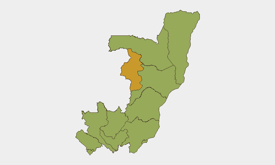
The Republic of Congo remains a composite threat-score rank of #34 globally (61/100), with a reporting gap in the last 24–48 hours limiting real-time incident confirmation. Cuvette-Ouest Department shows elevated risk (72.8), while 11 other administrative units cluster at 42.8—indicating dispersed, persistent hazards rather than acute concentration. The underlying security environment is characterized by multiple hazard classes (military activity, environmental events including active wildfires, and administrative friction), though discrete attack or clash data for the immediate past two days remain unavailable in multi-source corroborated form.
Key Developments
- 2026-07-22 · UK–DRC Bilateral Tension · Reduce Relations Signal
United Kingdom has signaled reduced relations with the Democratic Republic of the Congo (note: DRC and Republic of Congo are distinct entities; signal pertains to DRC). Two separate reduce-relations events logged on 2026-07-22; underlying cause and scope not detailed in available signal metadata but suggests diplomatic friction unrelated to Republic of Congo's immediate security.
- 2026-07-21 · Republic of Congo · Conventional Military Force Activity
Republic of Congo military activity registered on 2026-07-21; specific location, scale, and tactical context not detailed in current event feeds. Suggests routine or elevated posture rather than acute conflict event.
- 2026-07-21 · Republic of Congo · Public Statement
Official public statement issued by Congo Republic authorities (2026-07-21); content and target audience not yet available in curated briefing feeds.
- Multi-event Wildfire Cluster · Recent (pre-2026-07-22)
Seven separate wildfire events recorded across Congo Republic and Democratic Republic of Congo in recent days (events 1029490, 1029334, 1029361, 1029387, 1029390, 1029336, 1029364). Specific dates, burn area, and containment status not itemized; wildfires present secondary humanitarian and economic disruption risk, particularly in high-risk departments.
- Data-Collection Gap · 18–22 July 2026
Specialist monitoring confirms no clearly verified, time-stamped security or conflict incidents meeting multi-source corroboration standards within the past 24–48 hours. Gap likely reflects monitoring latency, operational lull, or absence of discrete reportable events rather than genuine de-escalation.
Highest-Risk Areas
Cuvette-Ouest Department (72.8) significantly outpaces all other administrative units, driving national composite risk. The remaining 11 departments cluster identically at 42.8—an unusual distribution suggesting either concentrated threat drivers in Cuvette-Ouest (resource competition, illegal activity, militia presence, or environmental hazard) or differential data collection. Pooled risk in the western and central departments (Bouenza, Plateaux, Pool, Niari, Kouilou, Lékoumou, Likouala, Sangha, Cuvette) and the capital region (Brazzaville) requires granular AOI monitoring and local intelligence to differentiate underlying hazard classes—criminal, environmental, or political.
How GeoBit Would Assist
Teams with personnel or assets in Congo should deploy AOI Monitoring & Early Warning on Cuvette-Ouest and secondary risk zones to detect incident onset with minimal latency. Network & Actor Analysis combined with OSINT fusion (including Telegram, radio SIGINT, and local open-source feeds in French) will help clarify the military activity signal and public statement from 2026-07-21. Satellite & Imagery analysis and Environmental & Health monitoring would track wildfire progression and secondary supply-chain or transportation impacts.
7-Day Outlook
No imminent, confirmed acute escalation is evident in the 24–48 hour window, but the reporting gap and Cuvette-Ouest concentration warrant close watch. Wildfire events may degrade infrastructure, displace populations, or create access denial; monitoring should flag humanitarian and logistics implications. Standard duty-of-care protocols (staff check-ins, alternate routing capability, asset relocation planning) should remain active in Cuvette-Ouest and western departments pending clarification of the military and diplomatic signals.
Highest-Risk Areas — Ranked
| # | State / Region | Risk |
|---|---|---|
| 1 | Cuvette-Ouest Department | 72.8 |
| 2 | Sangha | 42.8 |
| 3 | Likouala | 42.8 |
| 4 | Cuvette Department | 42.8 |
| 5 | Kouilou Department | 42.8 |
| 6 | Niari Department | 42.8 |
| 7 | Pointe-Noire (département) | 42.8 |
| 8 | Lékoumou Department | 42.8 |
| 9 | Bouenza Department | 42.8 |
| 10 | Plateaux Department | 42.8 |
| 11 | Pool Department | 42.8 |
| 12 | Brazzaville (department) | 42.8 |
Sources
Previous Daily Briefs
A new Congo brief is written every day — each with its own risk map and downloadable CSV. Here's the last week; use the calendar to go further back.
📅 Browse every day by calendar →
Highlighted days have a brief. Tap a day for that day's map & analysis, or “csv” for that day's dataset ($5).
Atlas — our AI intelligence desk — emails them this snapshot personally. Nothing else, no list.