Situation Summary
Croatia remains a stable EU and NATO member state with a composite threat ranking of #72 globally. No significant security incidents, civil unrest, infrastructure failures, or travel disruptions have been verified in the past 24–48 hours. The current security environment is characterized by routine operations and low acute risk for most of the country, with elevated baseline concerns concentrated in border regions with historical sensitivity.
Key Developments
No verified security, civil unrest, crime, or infrastructure incidents of national impact have been identified in Croatia during the 24–48 hour reporting window. Event signals flagged by GeoBit monitoring on 2026-06-14 and 2026-06-15 (public statements involving Zagreb and Croatian institutions) require local corroboration to determine operational relevance. Open-web and social-media research has not surfaced new attacks, major protests, political crises, or travel advisories. Recommendation: supplement this brief with real-time feeds from Croatian Ministry of the Interior, civil protection authorities, and your organization's operational channels to capture any developments occurring outside current intelligence access.
Highest-Risk Areas
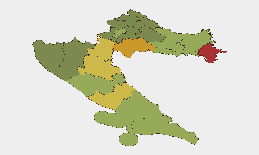
Vukovar-Srijem, Sisak-Moslavina, and Karlovac counties in eastern Croatia rank as the three highest-risk regions (scores 78, 72, 68 respectively), driven by proximity to the Serbian border, historical war-legacy contamination (unexploded ordnance, property disputes), and lower economic development. Lika-Senj and Šibenik-Knin counties follow (scores 65, 62), reflecting similar post-conflict vulnerabilities and border dynamics. These regions warrant enhanced due diligence for personnel deployments and asset protection; Zagreb and coastal Dalmatia (scores 50 and 48) present substantially lower risk and support the bulk of international business and tourism activity.
How GeoBit Would Assist
Security teams with people or assets in Croatia should use Intel Sweep and OSINT fusion to establish baseline profiles of personnel locations and supply-chain nodes, then activate area-of-interest (AOI) monitoring on high-risk border counties—particularly Vukovar-Srijem and Sisak-Moslavina—to generate alerts on protest activity, crime spikes, or infrastructure disruptions. Routing & network analysis can identify alternative transport corridors and safe havens for personnel in the eastern region. Periodic risk & threat assessment updates tied to regional political calendars or EU policy shifts will support duty-of-care compliance.
7-Day Outlook
No imminent acute security events are forecast for Croatia. Routine baseline risks (petty crime in urban centers, seasonal infrastructure maintenance) and border-region sensitivities are expected to remain stable. Organizations should maintain standard travel-security protocols and periodic local-threat monitoring without elevated alert status.
Note: This brief reflects GeoBit research capabilities as of 2026-06-16. Real-time security decisions require integration with official Croatian government channels, your organization's operational intelligence, and continuous monitoring of transport/infrastructure operators.
Highest-Risk Areas — Ranked
| # | State / Region | Risk |
|---|---|---|
| 1 | Vukovar-Srijem County | 78 |
| 2 | Sisak-Moslavina County | 72 |
| 3 | Karlovac County | 68 |
| 4 | Lika-Senj County | 65 |
| 5 | Šibenik-Knin County | 62 |
| 6 | Brod-Posavina County | 58 |
| 7 | Zadar County | 55 |
| 8 | Osijek-Baranja County | 52 |
| 9 | City of Zagreb | 50 |
| 10 | Split-Dalmatia County | 48 |
| 11 | Požega-Slavonia County | 45 |
| 12 | Virovitica-Podravina County | 42 |
Previous Daily Briefs
A new Croatia brief is written every day — each with its own risk map and downloadable CSV. Here's the last week; use the calendar to go further back.
📅 Browse every day by calendar →
Highlighted days have a brief. Tap a day for that day's map & analysis, or “csv” for that day's dataset ($5).