Situation Summary
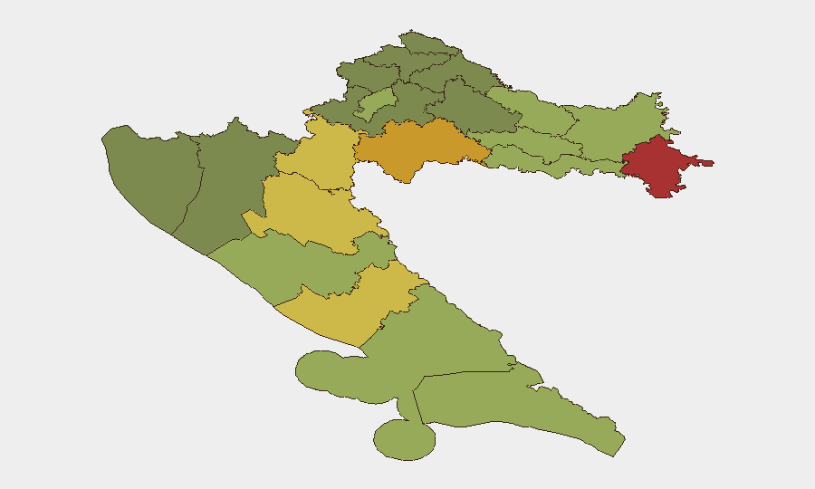
Croatia remains a low-threat environment globally (rank #164, composite score 7) with no tracked security incidents for the week ending October 20, 2026. Recent developments center on isolated law enforcement responses to football-related disorder and historical security concerns concentrated in the eastern border regions. The country's security posture continues to reflect post-conflict stabilization and integration into NATO and EU frameworks, with risk heavily concentrated in Vukovar-Srijem and Sisak-Moslavina counties along the Serbian frontier.
Key Developments
- Split, 15 October 2026: Police detained 57 people following an attempted confrontation between Hajduk Split and Ajax Amsterdam supporters near the Riva waterfront. Nineteen Ajax supporters received seven-day sentences and two-year stadium bans, though rulings remained subject to appeal; no injuries were reported.
- Split, 15–16 October 2026: Police began arresting at least 10 identified Torcida supporters on suspicion of inciting hatred under Croatia's public-incitement law, following allegations of antisemitic chants referencing Hitler and Auschwitz during the Hajduk–Ajax match on October 6.
- Zagreb, 14 October 2026: President Zoran Milanović approved Croatia's planned participation in NATO, EU, and UN missions for 2027–2028, including continued KFOR and Sea Guardian deployments and planned participation in the EU's ASPIDES maritime security operation. Parliamentary approval remained outstanding.
- UEFA Regulatory Action, 14 October 2026: UEFA fined the Croatian Football Federation €57,000 for supporter conduct during Croatia's 2–1 loss to Spain in Split on October 6, citing discriminatory behavior, pyrotechnics use, and blocked passageways.
Highest-Risk Areas
Eastern and border-adjacent counties—Vukovar-Srijem (risk 78), Sisak-Moslavina (72), and Karlovac (68)—drive the country's composite threat profile and reflect residual tensions and infrastructure challenges from the 1990s Balkans conflict. These regions continue to experience elevated criminality, weapons trafficking, and occasional organized crime activity related to cross-border movement with Serbia and Bosnia. Coastal and major urban centers including Zagreb (50) and Split-Dalmatia (48) carry significantly lower risk profiles, with recent disorder limited to organized football supporters and isolated public-order incidents rather than systemic security threats.
How GeoBit Would Assist
Security teams with personnel or assets in Croatia should employ AOI (Area-of-Interest) Monitoring & Early Warning on high-risk counties, particularly Vukovar-Srijem and Sisak-Moslavina, to detect emerging organized crime and cross-border trafficking patterns. Intel Sweep and multi-language OSINT fusion across regional Telegram, X, and local news feeds would provide early detection of crowd mobilization (e.g., football supporter networks) and extremist rhetoric before public incidents. For duty-of-care teams managing travel or events in Split and Zagreb, Event Signal tracking and Network & Actor Analysis enable real-time monitoring of organized football groups and their temporal clustering around matches.
7-Day Outlook
No significant escalation in security incidents is anticipated over the next seven days. Residual football-related tensions following the Hajduk–Ajax match may persist through late October as court proceedings advance, but organized violence remains limited to peripheral supporter groups rather than widespread disorder. Eastern border regions will continue to warrant baseline vigilance for organized crime and weapons trafficking, consistent with the country's longer-term risk profile.
Highest-Risk Areas — Ranked
| # | State / Region | Risk |
|---|---|---|
| 1 | Vukovar-Srijem County | 78 |
| 2 | Sisak-Moslavina County | 72 |
| 3 | Karlovac County | 68 |
| 4 | Lika-Senj County | 65 |
| 5 | Šibenik-Knin County | 62 |
| 6 | Brod-Posavina County | 58 |
| 7 | Zadar County | 55 |
| 8 | Osijek-Baranja County | 52 |
| 9 | City of Zagreb | 50 |
| 10 | Split-Dalmatia County | 48 |
| 11 | Požega-Slavonia County | 45 |
| 12 | Virovitica-Podravina County | 42 |
Previous Weekly Briefs
A new Croatia brief is written every Monday, covering the week — each with its own risk map and downloadable CSV. Use the calendar to go further back.
- October 13, 2026
- October 6, 2026
- September 29, 2026
- September 22, 2026
- September 15, 2026
- September 9, 2026
- September 3, 2026
📅 Browse past briefs by calendar →
Highlighted days have a brief. Tap a day for that day's map & analysis, or “csv” for that day's dataset ($5).
Atlas — our AI intelligence desk — emails them this snapshot personally. Nothing else, no list.