Situation Summary
Cyprus remains a divided island with ongoing political and military tensions centred on the Turkish-occupied north and the Republic of Cyprus–controlled south. The composite threat score of 10 reflects a structurally stable but geopolitically fragile environment with no acute security incidents recorded in the current tracking window. Defence and security postures remain elevated, particularly around military partnerships and NATO alignment, but operational threat activity is not currently manifesting in discrete incidents affecting corporate assets or personnel.
Key Developments
No discrete security incidents, infrastructure disruptions, civil unrest, or travel-risk events have been verified in Cyprus during the last 24–48 hours. Web research captured Defence Minister Vasilis Palmas statements on military partnerships and NATO aspirations, but these represent policy positions rather than operational developments or acute threats occurring in the reporting window.
Highest-Risk Areas
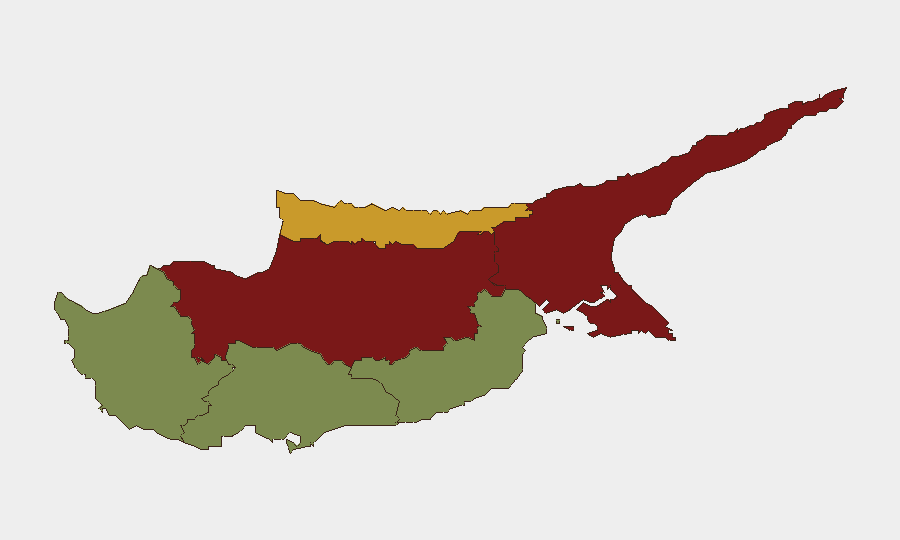
Nicosia (risk 92) and Famagusta (risk 88) dominate the sub-national risk ranking, both located in or near the Turkish-occupied north and the UN Buffer Zone that bisects the island. These areas carry structural political and military tension, checkpoints, and restricted access that elevate operational risk for corporate teams. Kyrenia (risk 72), also in the north, ranks third. Larnaca, Limassol, and Paphos—all in the Republic-controlled south—register substantially lower risk (28, 22, and 18 respectively), reflecting greater stability and standard commercial security environments. Risk concentration in the divided north reflects partition dynamics, military presence, and restricted movement rather than current acute incidents.
How GeoBit Would Assist
Teams operating in or near Nicosia, Famagusta, or Kyrenia should deploy AOI Monitoring & Early Warning to track persistent flashpoints and receive real-time alerts on civil unrest, military activity, or checkpoint disruptions. OSINT Fusion (X/Twitter, news, Telegram) would provide 24–48-hour operational intelligence on political statements, security posture changes, or cross-line tensions. Routing & Network Analysis would enable alternative journey planning around the Buffer Zone and checkpoints, reducing exposure to unpredictable access delays or confrontations. Regular Intel Sweeps on defence-ministry statements and cross-line rhetoric would provide early warning of escalation trajectories.
7-Day Outlook
No imminent acute threat is forecast for the next seven days. The political and military environment will likely remain in its current steady-state posture, with routine defence statements and NATO engagement continuing. Security teams should maintain baseline monitoring protocols and prepare contingency plans for the northern regions; the southern coast and commercial hubs remain suitable for standard duty-of-care practices.
Highest-Risk Areas — Ranked
| # | State / Region | Risk |
|---|---|---|
| 1 | Nicosia | 92 |
| 2 | Famagusta | 88 |
| 3 | Kyrenia | 72 |
| 4 | Larnaca | 28 |
| 5 | Limassol | 22 |
| 6 | Paphos | 18 |
Sources
Previous Daily Briefs
A new Cyprus brief is written every day — each with its own risk map and downloadable CSV. Here's the last week; use the calendar to go further back.
📅 Browse every day by calendar →
Highlighted days have a brief. Tap a day for that day's map & analysis, or “csv” for that day's dataset ($5).