Situation Summary
Dominican Republic remains at composite threat rank #69 globally, with no acute security incidents or civil unrest reported within Dominican territory in the last 24–48 hours. Structural risk remains concentrated in urban centers (Santo Domingo, Nacional District, Santiago) where gang activity, trafficking, and opportunistic crime persist as chronic baseline threats. The absence of new destabilizing events suggests security conditions are stable relative to the country's historical profile, though routine precautions for high-risk zones remain warranted.
Key Developments
- No verified acute incidents in Dominican Republic territory (last 24–48 hours). Independent open-source verification found no new security events, civil unrest, infrastructure disruption, or crime spikes meeting corporate security thresholds within the Dominican Republic in this period.
- Dominican-registered aircraft incident (regional, not domestic). A light aircraft registered in the Dominican Republic went missing on a flight between St. Vincent and Tobago (Eastern Caribbean), but authorities in St. Vincent and the Grenadines confirmed no crash or loss of life occurred. This is a regional aviation matter outside Dominican airspace and does not materially affect domestic security posture.
- Santiago cybersecurity infrastructure contract (planned, non-incident). DNV was engaged to provide cybersecurity services for the Santiago de los Caballeros monorail system. This reflects proactive risk management of critical transport infrastructure, not a breach, attack, or active threat.
- Diplomatic and seismic signals flagged but non-acute. Cross-checking with adjacent-territory security briefs confirmed that Dominican Republic–related signals in intelligence feeds during June 15–16 corresponded to diplomatic or natural-hazard monitoring activities, not domestic security incidents.
Highest-Risk Areas
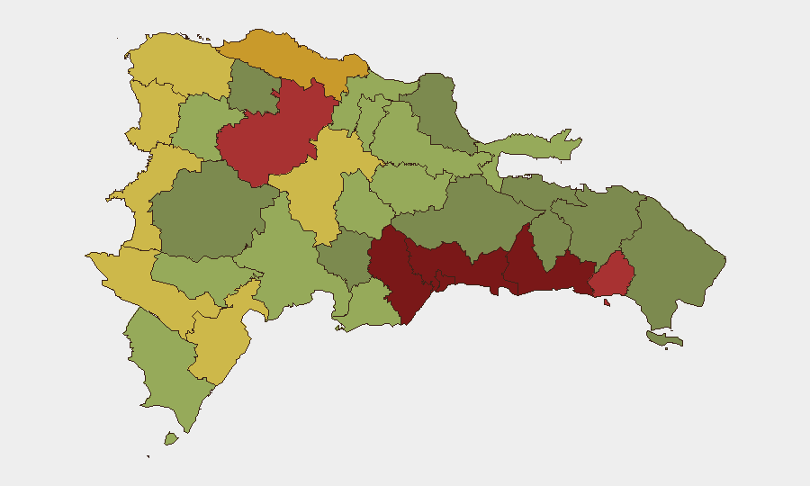
Santo Domingo (risk 92) and Nacional District (risk 88) drive the country's composite threat profile, followed by San Cristóbal, San Pedro de Macorís, and La Romana. These zones reflect sustained gang presence, trafficking infrastructure, and organized-crime territorial control rather than acute conflict or civil breakdown. Santiago (risk 76) and Puerto Plata (risk 72) represent secondary urban risk clusters, typically involving robbery, narcotics activity, and localized turf disputes. Border regions (Elías Piña, Dajabón) carry moderate risk linked to cross-border trafficking and informal trade; Independencia Province and Barahona reflect similar patterns. Corporate assets and personnel in high-risk areas should maintain baseline security protocols (secure accommodation, restricted movement after dark, vetted transportation, liaison with local security partners) rather than escalate to emergency posture absent specific incident intelligence.
How GeoBit Would Assist
Security teams monitoring Dominican Republic should employ Intel Sweep and global event-feed monitoring to detect any shift from chronic to acute risk (e.g., gang violence escalation, protest mobilization, political instability). OSINT fusion and sentiment analysis of Spanish-language social media and local news feeds would provide 24–48-hour early warning of emerging civil unrest or trafficking incidents affecting specific zones. AOI monitoring and alerting set on Santo Domingo, Santiago, and La Romana would flag real-time changes in activity patterns, while routing and network analysis could identify safe transit corridors and alternative logistical paths if conditions deteriorate.
7-Day Outlook
No trajectory shift is anticipated absent exogenous triggers (political instability, major gang realignment, or external intervention). Routine street crime, trafficking, and localized gang activity will remain the primary security driver in urban zones. Duty-of-care protocols should remain standard; escalation is not warranted on current evidence.
Highest-Risk Areas — Ranked
| # | State / Region | Risk |
|---|---|---|
| 1 | Santo Domingo | 92 |
| 2 | Nacional District | 88 |
| 3 | San Cristóbal | 85 |
| 4 | San Pedro de Macorís | 83 |
| 5 | La Romana | 78 |
| 6 | Santiago | 76 |
| 7 | Puerto Plata | 72 |
| 8 | Elías Piña | 70 |
| 9 | Dajabón | 68 |
| 10 | Barahona | 65 |
| 11 | Independencia Province | 64 |
| 12 | La Vega | 62 |
Sources
Previous Daily Briefs
A new Dominican Republic brief is written every day — each with its own risk map and downloadable CSV. Here's the last week; use the calendar to go further back.
📅 Browse every day by calendar →
Highlighted days have a brief. Tap a day for that day's map & analysis, or “csv” for that day's dataset ($5).