Situation Summary
Ecuador remains a mid-tier global security concern (rank #41, composite score 34.9) characterized by a sharp escalation in homicides, organized crime violence, and state emergency declarations across coastal and border provinces. The government has sustained military and police operations in Guayas, Los Ríos, El Oro, and Manabí, reporting a 37% surge in homicides in affected areas and ongoing confrontations with criminal networks. Recent signals indicate heightened conventional military deployments, cross-border tensions with Colombia, and domestic political friction. The threat environment is active and deteriorating in specific geographic zones rather than nationwide.
Key Developments
- Guayaquil (Guayas) – Level 4 "Do Not Travel" designation expanded. The area south of Avenida Portete de Tarqui remains under U.S. State Department Level 4 status due to terrorism and extreme violent crime, with reported increases in both frequency and brutality of attacks. Military and police checkpoints are active across the city.
- Military/Police operations ongoing (2026-06-01/03). Signals show continued conventional military force deployments and military/police power shows as of 2026-06-03, consistent with sustained state of emergency operations in coastal provinces.
- Colombia border tensions escalating (2026-06-01/03). Ecuador initiated investigation signals toward Colombia and made arrest/detain actions related to Colombian nationals on 2026-06-03, suggesting cross-border security incidents or apprehensions tied to trafficking or armed group activity.
- Durán and Los Ríos corridor remains high-risk. Durán canton (across from Guayaquil), Quevedo, Quinsaloma, and Pueblo Viejo are designated "Do Not Travel" zones due to terrorism and organized crime linked to cartel and gang violence in the agricultural belt.
- Esmeraldas and northern border provinces – narcotrafficking nexus. Esmeraldas city and areas north toward Colombia, plus Carchi, remain designated "Do Not Travel" due to terrorist and criminal group activity along the narcotrafficking corridor.
- Sucumbíos province (Amazon/Colombia border) – reconsider-travel status. Colombian and local armed groups operate along oil infrastructure and border rivers; ambushes and illegal checkpoints reported.
- Nationwide demonstration and roadblock risk. Protests are ongoing across urban centers, blocking highways and airport access without notice; secondary crime (theft/assault) around protest sites is documented.
- Homicide and extortion surge. Over 2,000 kidnapping reports and 10,700 extortion reports were filed in 2024; homicide rates are at unprecedented levels nationwide.
Highest-Risk Areas
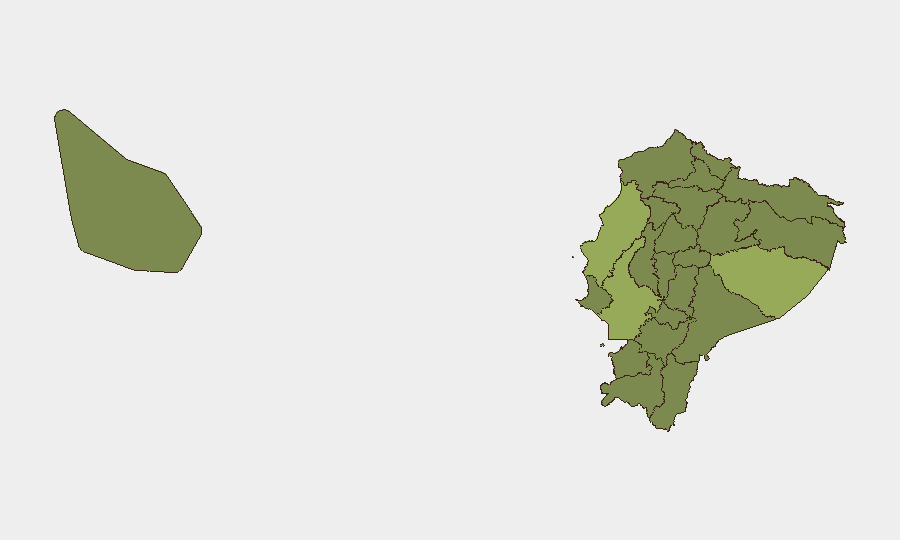
Pastaza, Guayas, and Manabí provinces drive the highest composite risk scores (54.4, 48.3, and 45.2 respectively), reflecting active criminal violence, state emergency declarations, and military operations. Guayas alone contains multiple Level 4 "Do Not Travel" zones in and around Guayaquil and Durán, where terrorism and organized crime create sustained threat to personnel and assets. Northern border provinces (Esmeraldas, Sucumbíos, Carchi) and southern Peru/Colombia border zones (El Oro) are secondary high-risk concentrations driven by transnational trafficking and armed-group activity. Pichincha (Quito) and central provinces show elevated but lower absolute risk, though demonstrations and secondary urban crime remain concerns.
How GeoBit Would Assist
Security teams would employ AOI Monitoring & Early Warning to track real-time events and deployments in Guayas, Pastaza, and border provinces, with alerting on military/police activity and protest activity. Routing & Network Analysis capabilities would support alternative journey planning to avoid Level 4 zones and known roadblocks in Los Ríos and coastal corridors. Intel Sweep, OSINT fusion, and network/actor analysis would provide ongoing monitoring of criminal organization movements, cross-border incidents, and government response signals to inform duty-of-care decisions for staff movements and asset positioning.
7-Day Outlook
Military and police operations are expected to continue at current intensity in coastal and border provinces through the operational cycle. Demonstration activity may intensify around political or economic triggers; personnel should monitor local advisories and avoid protest concentrations. Cross-border tensions with Colombia warrant heightened vigilance in Esmeraldas and Sucumbíos; no near-term de-escalation is signaled.
Highest-Risk Areas — Ranked
| # | State / Region | Risk |
|---|---|---|
| 1 | Pastaza Province | 54.4 |
| 2 | Guayas Province | 48.3 |
| 3 | Manabí Province | 45.2 |
| 4 | Pichincha Province | 33.7 |
| 5 | Tungurahua Province | 27.5 |
| 6 | Loja Province | 25.2 |
| 7 | Sucumbíos Province | 24.4 |
| 8 | Orellana Province | 24.4 |
| 9 | Galápagos | 24.4 |
| 10 | Esmeraldas Province | 24.4 |
| 11 | Carchi Province | 24.4 |
| 12 | Imbabura Province | 24.4 |
Previous Daily Briefs
A new Ecuador brief is written every day — each with its own risk map and downloadable CSV. Here's the last week; use the calendar to go further back.
📅 Browse every day by calendar →
Highlighted days have a brief. Tap a day for that day's map & analysis, or “csv” for that day's dataset ($5).