Situation Summary
Equatorial Guinea remains at low acute-incident risk (#94 globally; composite threat score 13) with no publicly reported security, civil-unrest, or crime incidents in the last 24–48 hours. Two signals flagged in GEOBIT's event feed (Australian conventional military force and national army mobilization on 2026-06-29) lack corroborated open-source detail and do not currently connect to confirmed domestic incidents or international military activity within Equatorial Guinea's borders. The security environment is stable but structurally fragile: Bioko Norte (risk 85) and Litoral Province (risk 78) remain elevated due to historical tensions, maritime crime exposure, and cross-border vulnerabilities, though no acute trigger events are evident in real-time feeds.
Key Developments
- No acute incidents confirmed · Nationwide · 27–29 June 2026
Open-source security monitoring, regional briefs, and cross-regional OSINT (covering the Gulf of Guinea and Central Africa) report no verified shootings, civil unrest, infrastructure attacks, abductions, or criminal events specific to Equatorial Guinea within the last 48 hours.
- Military mobilization signals flagged · 2026-06-29 · Source ambiguity
GEOBIT event feeds registered signals for Australian conventional military force and national army mobilization dated 2026-06-29, but open-source corroboration and geographic specificity remain unconfirmed; intelligence sweep and multi-source OSINT fusion indicate no linked domestic incident or public military announcement.
- Diplomatic and energy engagement · Regional · 28 June 2026
Gulf of Guinea energy and development discussions (including references to Equatorial Guinea) in statements and social media reflect standard bilateral and sectoral activity; no security disruption or political instability evident in diplomatic channels.
- No regional spillover · Border areas · 27–29 June 2026
Regional security briefs for Cameroon and cross-border zones report no incidents involving Equatorial Guinea; maritime monitoring in the Gulf of Guinea shows no new attacks or disruptions tied to Equatorial Guinea territory or waters.
Highest-Risk Areas
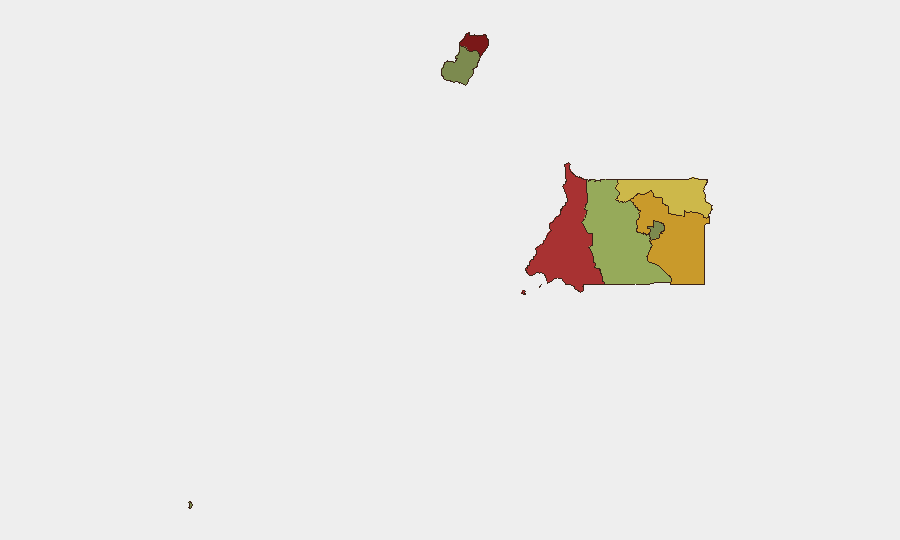
Bioko Norte (85) and Litoral Province (78) drive the composite risk ranking, reflecting maritime exposure to Gulf of Guinea piracy networks, historical civil-society friction, and porous border dynamics with Cameroon and Gabon. Wele-Nzas (72) and Kié-Ntem (68) carry elevated scores due to border permeability and weak state presence in remote areas. Centro Sur, Bioko Sur, Djibloho, and Annobón carry significantly lower risk profiles; the concentration of concern in the northern and western regions reflects persistent structural vulnerabilities rather than acute recent escalation.
How GeoBit Would Assist
Corporate security teams should employ AOI (area-of-interest) monitoring and early-warning alerting across Bioko Norte and Litoral Province to detect emerging unrest, maritime incidents, or cross-border activity in real time. Multi-language OSINT fusion, entity extraction, and sentiment analysis on X, Telegram, and local media can surface early-stage civil or commercial friction before it reaches incident status. Maritime and aviation tracking, combined with conflict and regime-stability assessment, enable duty-of-care teams to preempt travel disruption and verify personnel safety in high-risk zones.
7-Day Outlook
No acute escalation is forecast for the next seven days. Structural vulnerabilities in Bioko Norte and maritime zones persist, but absent new political, economic, or cross-border shocks, the security environment should remain calm. Continued monitoring of military signal detail and regional maritime activity is warranted to clarify the 2026-06-29 mobilization flags.
Highest-Risk Areas — Ranked
| # | State / Region | Risk |
|---|---|---|
| 1 | Bioko Norte | 85 |
| 2 | Litoral Province | 78 |
| 3 | Wele-Nzas Province | 72 |
| 4 | Kié-Ntem Province | 68 |
| 5 | Centro Sur Province | 45 |
| 6 | Bioko Sur | 38 |
| 7 | Djibloho | 15 |
| 8 | Annobón Province | 8 |
Sources
Previous Daily Briefs
A new Equatorial Guinea brief is written every day — each with its own risk map and downloadable CSV. Here's the last week; use the calendar to go further back.
📅 Browse every day by calendar →
Highlighted days have a brief. Tap a day for that day's map & analysis, or “csv” for that day's dataset ($5).