Situation Summary
Estonia remains a low-threat environment (composite score 7) with stable but heightened border security posture and no acute security emergencies. However, emerging economic stress, a rising theft trend in urban areas, and infrastructure vulnerabilities in the eastern frontier present gradual drift toward elevated operational risk. The security picture is characterized by preventive measures rather than reactive crisis response, with authorities maintaining open borders while positioning rapid-closure capability.
Key Developments
- Southeast border area, 22 July 2026 – New drone-monitoring system activated on the first sections of Estonia's external frontier to detect unmanned aircraft and counter hostile or illegal drone activity, reflecting proactive border-security hardening.
- Estonia–Russia land border, 20 July 2026 – Interior Minister Igor Taro confirmed the eastern border remains open due to absence of immediate threat, but authorities maintain rapid-closure readiness should the security situation change.
- Tallinn spa center, 20 July 2026 – Four individuals required emergency medical treatment following carbon monoxide inhalation; incident contained but underscores workplace safety and emergency-response vulnerabilities in hospitality infrastructure.
- Nationwide crime trend, 21 July 2026 – Police reported 6,300+ thefts registered year-to-date, representing a 12% increase versus prior-year baseline; incidents primarily classified as petty theft linked to victim carelessness but indicating gradually elevated urban crime risk.
- Nationwide economic indicator, 21 July 2026 – Estonia's Competition Authority flagged rising corporate insolvencies as an emerging internal security concern, linking economic stress to potential social stability and crime spillover effects.
- Nationwide healthcare infrastructure, 21 July 2026 – Health Board and Health Insurance Fund announced planned ambulance network reform reducing team size to two-person crews and cutting night brigades, with potential impact on emergency-response capacity in remote and high-risk regions.
- Valga County, 22 July 2026 – Temporary road closure on Valga–Suurekõrtsi route (km 17, 08:00–20:00) for roadworks, affecting ground transit in southern Estonia's second-highest-risk sub-national area.
Highest-Risk Areas
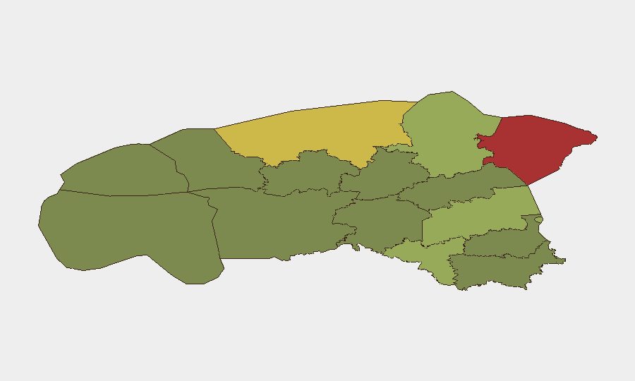
Ida-Viru County (risk 78) and Harju County (risk 68) dominate the regional risk profile, driven by proximity to Russia, infrastructure concentration, and cross-border activity vectors. Ida-Viru's elevated score reflects its position as Estonia's primary eastern frontier zone; Harju encompasses Tallinn and metropolitan vulnerabilities including the reported carbon monoxide incident and elevated petty-crime activity. Tartu County (58) and Valga County (55) represent secondary risk corridors in the southeast and south respectively, where border-security operations and economic stress intersect. Western and southern counties (Pärnu, Põlva, Võru <35) remain lower-risk zones.
How GeoBit Would Assist
Corporate security teams operating in Estonia would deploy AOI Monitoring & Early Warning capabilities to track Ida-Viru and Harju counties for escalation signals (border incidents, infrastructure disruptions, crime clustering) with 24–48-hour alerting. Routing & Network Analysis would enable real-time alternative-route planning around road closures and border-status changes, critical for supply-chain and personnel-movement continuity. Risk & Threat Assessment integrated with OSINT (government statements, regulatory announcements, local news) would provide continuous economic-stress and crime-trend visibility, allowing duty-of-care teams to adjust staffing, travel policy, and emergency protocols ahead of cascading instability.
7-Day Outlook
No acute security spike is forecast over the next seven days. Border posture will remain stable but vigilant; the new drone-monitoring system and stated rapid-closure readiness suggest a defensive rather than offensive trajectory. Gradual risks—rising theft, insolvency clustering, and ambulance-network delays—will likely persist and warrant continuous monitoring rather than immediate escalation.
Highest-Risk Areas — Ranked
| # | State / Region | Risk |
|---|---|---|
| 1 | Ida-Viru County | 78 |
| 2 | Harju County | 68 |
| 3 | Tartu County | 58 |
| 4 | Valga County | 55 |
| 5 | Lääne-Viru County | 52 |
| 6 | Pärnu County | 35 |
| 7 | Rapla County | 32 |
| 8 | Jõgeva County | 30 |
| 9 | Järva County | 28 |
| 10 | Viljandi County | 25 |
| 11 | Põlva County | 22 |
| 12 | Võru County | 18 |
Sources
Previous Daily Briefs
A new Estonia brief is written every day — each with its own risk map and downloadable CSV. Here's the last week; use the calendar to go further back.
📅 Browse every day by calendar →
Highlighted days have a brief. Tap a day for that day's map & analysis, or “csv” for that day's dataset ($5).
Atlas — our AI intelligence desk — emails them this snapshot personally. Nothing else, no list.