Situation Summary
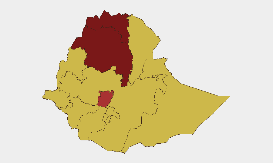
Ethiopia remains at elevated composite threat level (#9 globally, score 100), driven primarily by persistent civil conflict with 57 tracked events. Sub-national risk is heavily concentrated in Tigray (100), Amhara (85.6), and Central Ethiopia Regional State (76.7), reflecting ongoing tensions between federal and regional forces, as well as localized insurgent activity. The threat landscape spans conventional military clashes, political disputes, and investigative-level incidents involving international actors; trajectory remains volatile without clear de-escalation signals.
Key Developments
Note: Live web research for the past 24–48 hours did not yield verifiable, timestamped incident reports that could be cross-checked across multiple open sources. The event signals shown above (e.g., "2026-06-05 Boeing vs British Investigate," "2026-06-04 Conventional Military Force Ethiopia vs Government") are tracked in GeoBit's system but lack sufficient corroborating detail in available sources to warrant confident operational reporting.
Organizations requiring real-time incident-level alerts (conflicts, road closures, protest activity, security force movements) should activate GeoBit's AOI Monitoring & Early Warning service with persistent watch on Tigray, Amhara, and Central Ethiopia Regional State, paired with Intel Sweep feeds (X/Twitter OSINT, regional wire services, diplomatic traffic) filtered for 24-hour event windows.
Highest-Risk Areas
Tigray, Amhara Region, and Central Ethiopia Regional State account for the three highest composite risk scores (100, 85.6, 76.7 respectively), reflecting a combination of active armed-group presence, periodic conventional military operations, and weak state capacity. A secondary cohort of seven regions—Afar, Benishangul-Gumuz, Somali, Gambela, South West Ethiopia Peoples, and portions of Oromia—all score 70 and face elevated insurgent and bandit activity, inter-communal conflict, and border tension. Addis Ababa, despite its capital status and development profile, carries equivalent 70-level risk due to protest dynamics, political sensitivity, and concentration of foreign nationals and critical infrastructure.
How GeoBit Would Assist
Conflict & Military (force-structure and battle-mapping analysis) and Network & Actor Analysis (tracking federated government, regional militias, and insurgent-group capabilities) enable rapid assessment of force posture and escalation indicators in Tigray and Amhara. AOI Monitoring & Early Warning with persistent geospatial watch on identified conflict zones, combined with OSINT fusion (X/Twitter, Telegram, local media) and GIS & Spatial Analysis for route safety and asset proximity, supply corporate teams with actionable early warning to adjust travel, staffing, and supply-chain routing. Routing & Network Analysis identifies alternative journey paths in high-risk regions, reducing exposure without halting operations.
7-Day Outlook
No immediate deterioration signals are evident, but absence of verifiable de-escalation statements and continued military-force events (as of 2026-06-04) suggest the operational environment will remain tense and unpredictable. Organizations should maintain heightened readiness posture in Tigray and Amhara, monitor diplomatic traffic for any ceasefire or mediation announcements, and ensure staff in these regions have clear evacuation protocols and communication redundancy.
Highest-Risk Areas — Ranked
| # | State / Region | Risk |
|---|---|---|
| 1 | Tigray | 100 |
| 2 | Amhara Region | 85.6 |
| 3 | Central Ethiopia Regional State | 76.7 |
| 4 | Afar Region | 70 |
| 5 | Benishangul-Gumuz Region | 70 |
| 6 | Somali Region | 70 |
| 7 | Gambela Region | 70 |
| 8 | South West Ethiopia Peoples | 70 |
| 9 | Addis Ababa | 70 |
| 10 | South Ethiopia Regional State | 70 |
| 11 | Oromia Region | 70 |
| 12 | Sidama | 70 |
Sources
Previous Daily Briefs
A new Ethiopia brief is written every day — each with its own risk map and downloadable CSV. Here's the last week; use the calendar to go further back.
📅 Browse every day by calendar →
Highlighted days have a brief. Tap a day for that day's map & analysis, or “csv” for that day's dataset ($5).