Situation Summary
Finland remains operationally stable with no confirmed acute security incidents, civil unrest, major crime spikes, or infrastructure disruption reported in the last 24–48 hours by multi-source monitoring or leading national outlets. The country maintains its position as a lower-threat environment globally (rank #177), though regional variation exists within Finland itself. Current threat posture remains unchanged from the previous reporting cycle.
Key Developments
No verified security incidents meeting acute-event criteria have been confirmed in Finland during the 24–48 hour reporting window (14–16 July 2026). Multi-source open-source security monitoring, domestic media outlets (Helsinki Times, Yle), and executive risk reporting indicate no new civil unrest, violent crime, infrastructure disruption, political instability, or travel safety events in that timeframe. Several policy and diplomatic matters (NATO statements, ministerial announcements, legislative debate on border security) have been reported on 15–16 July, but these constitute administrative or rhetorical developments rather than operational security incidents affecting personnel or asset safety. Any earlier incidents (e.g., police investigations, criminal cases, accidents, cyber warnings) are dated prior to 14 July and thus fall outside the current 24–48 hour window; background context on those matters is available upon request but is not presented as current development.
Highest-Risk Areas
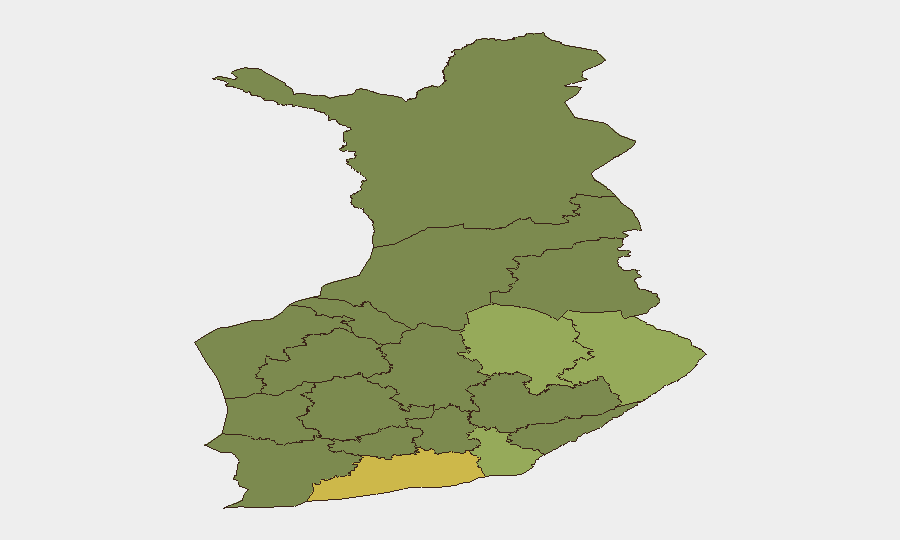
Uusimaa (score 65)—anchored by the Helsinki metropolitan region—drives the majority of Finland's tracked risk events, reflecting population density, economic activity, and administrative concentration rather than acute instability. North Karelia (44), Kymenlaakso (42), and North Savo (40) show elevated scores, likely reflecting border-proximity factors, historical event clustering, or cross-border activity patterns. The southern and eastern regions (Uusimaa, North Karelia, Kymenlaakso, South Karelia) collectively account for the highest risk density; teams with personnel or assets concentrated in these regions should maintain standard monitoring. Conversely, Central Finland, Southwest Finland, and Kanta-Häme represent lower-risk operating environments within the country.
How GeoBit Would Assist
Corporate security teams in Finland should leverage Intel Sweep and global event feeds to maintain real-time awareness of any emerging incidents or policy changes affecting operations, paired with multi-language search and sentiment analysis to capture Finnish and regional media reporting on labor, political, or civil developments. AOI Monitoring & Early Warning on high-risk regions (particularly Uusimaa and North Karelia) provides persistent alerting if conditions deteriorate, while Network & Actor Analysis can map potential stakeholder positions during legislative or diplomatic shifts. For teams requiring situational assurance before travel or asset deployment, Routing & Network Analysis offers validated alternative movement planning.
7-Day Outlook
No imminent security deterioration is indicated for the next seven days. Finland is expected to remain stable; ongoing administrative and policy discussions (border security legislation, NATO alignment statements) will likely continue without operational impact on corporate security. Duty-of-care teams should maintain standard vigilance protocols and monitor for any policy or regulatory changes affecting business operations, but no acute threat escalation is forecast for the near term.
Highest-Risk Areas — Ranked
| # | State / Region | Risk |
|---|---|---|
| 1 | Uusimaa | 65 |
| 2 | North Karelia | 44 |
| 3 | Kymenlaakso | 42 |
| 4 | North Savo | 40 |
| 5 | South Karelia | 38 |
| 6 | Kainuu | 36 |
| 7 | Päijät-Häme | 35 |
| 8 | South Savo | 32 |
| 9 | Kanta-Häme | 30 |
| 10 | Pirkanmaa | 28 |
| 11 | Central Finland | 26 |
| 12 | Southwest Finland | 25 |
Sources
Previous Daily Briefs
A new Finland brief is written every day — each with its own risk map and downloadable CSV. Here's the last week; use the calendar to go further back.
📅 Browse every day by calendar →
Highlighted days have a brief. Tap a day for that day's map & analysis, or “csv” for that day's dataset ($5).
Atlas — our AI intelligence desk — emails them this snapshot personally. Nothing else, no list.