Situation Summary
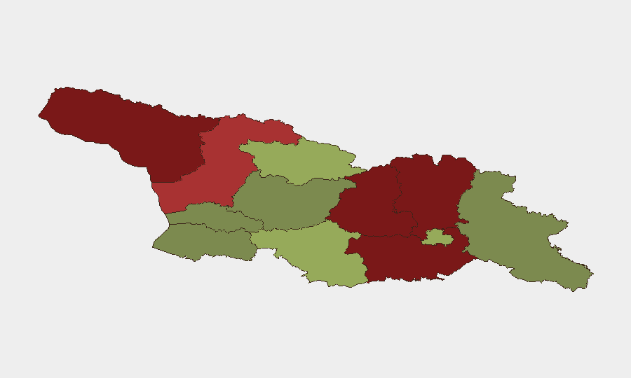
Georgia presents a low overall security threat profile (composite score 3; #null globally) with minimal tracked acute incidents in the last 24–48 hours. However, sub-national risk remains severely concentrated in the occupied and disputed territories of Abkhazia and South Ossetia (Shida Kartli, Lower Kartli, Mtskheta-Mtianeti), where geopolitical tension, de facto control, and limited state authority persist. Risk in the capital and major urban centers (Tbilisi risk 45) remains moderate; peripheral regions show significantly lower threat. The security environment is stable but structurally fragile.
Key Developments
GeoBit's live web research was unable to identify verifiably timestamped security, conflict, civil-unrest, crime, or infrastructure incidents in Georgia within the last 24–48 hours that could be corroborated across independent sources. A flood event (Event ID 1103909) is listed in GEOBIT EVENT SIGNALS but lacks sufficient current detail to characterize its scope, location, or ongoing impact.
Corporate security teams should note:
- No acute security escalation, civil unrest, armed activity, or major crime surge is currently confirmed for the last two days.
- Ongoing structural risks in Abkhazia and South Ossetia (de facto separatist control, Russian military presence, disputed sovereignty) remain unchanged and require standing monitoring.
- MARTA (Atlanta transit) security: Federal investigation into violent attacks on regional transit is ongoing but represents a persistent structural issue, not a fresh incident window trigger.
Highest-Risk Areas
The Autonomous Republic of Abkhazia (risk 95) and South Ossetia/Shida Kartli region (risk 88) are the primary drivers of Georgia's composite threat. These territories operate under de facto separatist control, with Russian military presence and minimal Georgian state authority—creating zones of limited predictability and rule-of-law gaps. Lower Kartli (risk 85) and Mtskheta-Mtianeti (risk 82) are similarly affected by disputed sovereignty and armed de facto structures.
By contrast, Tbilisi (risk 45), Imereti (risk 32), and Guria (risk 28) reflect much lower threat, with functioning state institutions and routine law enforcement. Samtskhe-Javakheti (risk 48) merits note as a secondary risk zone due to historical Armenian-Azerbaijani tension and proximity to the Armenia–Azerbaijan border.
How GeoBit Would Assist
OSINT & Intel Sweep would establish real-time monitoring of Abkhazia and South Ossetia for military movement, diplomatic signaling, and cross-border activity via X/Telegram, local media, and open-source imagery. AOI Monitoring & Early Warning with persistent watch on Gali (Abkhazia), Tskhinvali (South Ossetia), and key border crossings would trigger alerts on force repositioning or violence. GIS & Spatial Analysis and Satellite & Imagery Analysis would provide teams with timely route-risk assessment, alternative routing for personnel and shipments, and visibility into infrastructure stability in both stable and disputed zones.
7-Day Outlook
No acute escalation is forecast for the next 7 days based on current open-source signals. Structural risks—de facto separatist control, Russian military posture, and limited Georgian state authority in occupied territories—will persist as a chronic threat to supply chains and personnel movement in northern Georgia. Routine monitoring of cross-border activity and diplomatic signaling remains essential for early-warning on any shift in regional posture.
GeoBit | Daily Security Brief | 2026-06-11
Highest-Risk Areas — Ranked
| # | State / Region | Risk |
|---|---|---|
| 1 | Autonomous Republic of Abkhazia | 95 |
| 2 | Shida Kartli | 88 |
| 3 | Lower Kartli | 85 |
| 4 | Mtskheta-Mtianeti | 82 |
| 5 | Samegrelo-Upper Svaneti | 78 |
| 6 | Samtskhe-Javakheti | 48 |
| 7 | Tbilisi | 45 |
| 8 | Racha-Lechkhumi and Kvemo Svaneti | 42 |
| 9 | Kakheti | 38 |
| 10 | Autonomous Republic of Adjara | 35 |
| 11 | Imereti | 32 |
| 12 | Guria | 28 |
Sources
Previous Daily Briefs
A new Georgia brief is written every day — each with its own risk map and downloadable CSV. Here's the last week; use the calendar to go further back.
📅 Browse every day by calendar →
Highlighted days have a brief. Tap a day for that day's map & analysis, or “csv” for that day's dataset ($5).