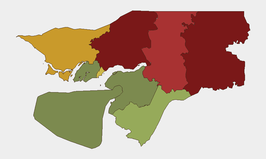
Situation Summary
Guinea-Bissau territory remains calm and structurally stable with no new security incidents, civil unrest, or infrastructure disruptions recorded in the past 24–48 hours. The primary security concern affecting Guinea-Bissau interests is maritime-based: a Guinea-Bissau-flagged vessel was struck by Russian missiles in the Black Sea on 19 July 2026, resulting in 10 deaths and demonstrating acute risk to commercial shipping under the country's flag in active conflict zones. Domestic political tensions (including detention of opposition figure Domingos Simões Pereira and strained Cape Verde relations) remain unchanged. Overall risk trajectory is stable domestically; maritime exposure is elevated.
Key Developments
- Black Sea, off Odesa, Ukraine – 19 July 2026 (reported 20 July 2026): Russian cruise-missile strike on the Golden Leo, a Guinea-Bissau-flagged Turkish-owned bulk carrier, caused major fire, 10 confirmed deaths (nine crew, one Ukrainian sea pilot), and eight rescued personnel. Indian foreign ministry confirms four Indian sailors killed and one critically injured; crew was multinational (India, Syria, Ukraine). Ukrainian naval authorities characterize the strike as a "terrorist act" and violation of international humanitarian law, flagging elevated risk to all commercial shipping under Guinea-Bissau flag in the Black Sea corridor.
- Guinea-Bissau territory nationwide – 19–20 July 2026: Multi-source commercial and diplomatic monitoring reports no new security incidents, violence, armed activity, civil unrest, curfews, movement restrictions, or infrastructure disruptions across the country. Assessment: calm and stable conditions persist.
- Bissau and national road network – 19–20 July 2026: No new petty-crime spikes or abrupt deterioration recorded; standing foreign travel advisories (e.g., France MFA) continue to warn of routine risks (night travel, valuables security, crowd avoidance) but report no fresh incidents within this window.
- Northeastern provinces (Gabu, Oio, Bafatá) – 19–20 July 2026: No new armed activity or concrete incidents documented in the current reporting window, despite structural elevation of risk scores in these regions due to regional dynamics.
Highest-Risk Areas
Gabu Region (risk 92) and Oio Region (risk 85) dominate the sub-national risk profile, followed by Bafatá (78) and Cacheu (72). These northeastern and northern border areas carry elevated scores reflecting cross-border dynamics, trafficking exposure, and regional instability factors that predate this reporting window. Bissau Autonomous Sector (68) ranks fifth, driven by petty crime and urban-congestion risks. Critically, none of these areas show new incident activity in the last 24–48 hours; risk scores reflect structural vulnerability rather than acute current events. Southern regions (Tombali, Quinara, Biombo, Bolama) carry substantially lower scores.
How GeoBit Would Assist
Security teams monitoring Guinea-Bissau should employ AOI Monitoring & Early Warning to track the northeastern high-risk provinces for any shift in armed activity or cross-border movement, and Maritime & Aviation tracking to monitor Guinea-Bissau-flagged vessels operating in conflict-affected waters (particularly the Black Sea and Gulf of Guinea), with automated alerting for geopolitical or weather threats. Intel Sweep (global event feeds, multi-language OSINT, entity extraction) combined with Risk & Threat Assessment would provide continuous duty-of-care coverage of political detention developments and regional tension escalation, enabling rapid escalation protocols if domestic or maritime conditions degrade.
7-Day Outlook
Domestic Guinea-Bissau security outlook remains stable with no indicators of abrupt change in the coming week. Maritime risk to flag-state assets remains elevated while the Black Sea corridor remains an active strike zone; commercial operators should assume heightened exposure. Political tensions are unlikely to escalate materially in the short term absent external triggering events.
Highest-Risk Areas — Ranked
| # | State / Region | Risk |
|---|---|---|
| 1 | Gabu Region | 92 |
| 2 | Oio Region | 85 |
| 3 | Bafatá Region | 78 |
| 4 | Cacheu Region | 72 |
| 5 | Bissau Autonomous Sector | 68 |
| 6 | Tombali Region | 45 |
| 7 | Quinara Region | 38 |
| 8 | Biombo Region | 32 |
| 9 | Bolama Region | 15 |
Sources
Previous Daily Briefs
A new Guinea-Bissau brief is written every day — each with its own risk map and downloadable CSV. Here's the last week; use the calendar to go further back.
📅 Browse every day by calendar →
Highlighted days have a brief. Tap a day for that day's map & analysis, or “csv” for that day's dataset ($5).
Atlas — our AI intelligence desk — emails them this snapshot personally. Nothing else, no list.