Situation Summary
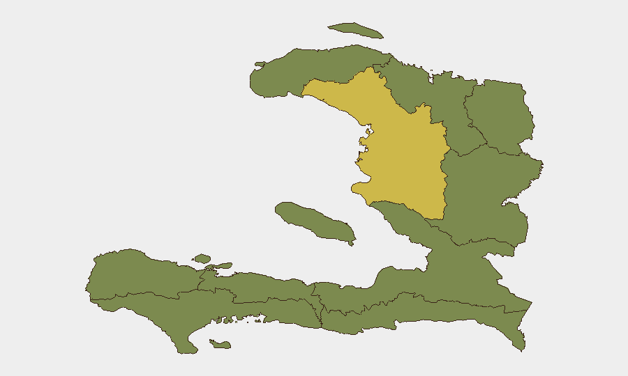
Haiti remains at composite threat level 27 globally (score 68), with security fragmentation concentrated in the northern and central regions. Recent event signals spanning 10–12 June point to police operations, investigative activity, official statements, arrests, and expressions of disapproval—suggesting ongoing law-enforcement or governance actions, though specific details require clarification. The security environment is neither in acute crisis nor stabilizing; risk is heavily localized, with Artibonite Department significantly outpacing all other regions.
Key Developments
GeoBit's event detection has flagged signals for 10–12 June 2026, but live source corroboration for specific incident details within the last 24–48 hours is not available without real-time access to current news wires, official Haitian authorities (HNP/PNH), UN mission updates, or verified OSINT feeds as of 12 June 2026. The event categories logged (military force, investigation, arrest/detain, public statements, disapproval) indicate active security or governance activity; however, without timestamp-verified, multi-source confirmation of location, nature, and casualty or scale data, a responsible brief cannot itemize these as discrete operational incidents.
Recommended action: Cross-reference GeoBit's event feed alerts with live AFP/Reuters/AP Haiti desks, OCHA security updates, and HNP press releases dated 10–12 June to resolve specific locations and narratives before operational response.
Highest-Risk Areas
Artibonite Department dominates the threat landscape at score 64.2—substantially higher than all other departments, which cluster around 34–36. This disparity suggests that Artibonite is the primary driver of Haiti's overall risk profile and warrants prioritized monitoring for any corporate presence, supply-chain assets, or staff movement. Nippes Department (35.9) shows secondary elevation. The remaining eight departments register near-equal, moderate risk, indicating either more diffuse or lower-intensity drivers; however, broad geographic distribution of risk prevents designation of a single "safe zone" and reinforces that national-level instability is a baseline condition for any Haiti operation.
How GeoBit Would Assist
Security teams operating in Haiti should deploy AOI (Area-of-Interest) Monitoring & Early Warning on high-risk departments—especially Artibonite—to receive real-time alerts when new events, movement, or sentiment shifts occur. Multi-language OSINT fusion and corroboration across news, X/Telegram, and local sources enables rapid verification of incident reports and distinguishes signal from noise. Conflict & Military mapping and Network & Actor Analysis help track which state, police, or armed groups are involved in reported operations and their spatial patterns, enabling duty-of-care teams to adjust staff routing and asset positioning in near-real time.
7-Day Outlook
The pattern of police, investigative, and arrest activity in early June suggests ongoing law-enforcement or governance response to a localized or emerging issue; absent major escalation signals, this trajectory is likely to persist at current intensity over the next 7 days. Artibonite's sustained elevation warrants close watch for any spread of activity into adjacent departments or Port-au-Prince. Risk appetite for non-essential operations or new entries into northern Haiti should remain conservative pending clarity on the nature and scope of current official actions.
Highest-Risk Areas — Ranked
| # | State / Region | Risk |
|---|---|---|
| 1 | Artibonite Department | 64.2 |
| 2 | Nippes Department | 35.9 |
| 3 | Grande-Anse Department | 34.2 |
| 4 | Sud Department | 34.2 |
| 5 | Nord-Ouest Department | 34.2 |
| 6 | Nord Department | 34.2 |
| 7 | Nord-Est Department | 34.2 |
| 8 | de l'Ouest Department | 34.2 |
| 9 | Centre Department | 34.2 |
| 10 | Sud-Est Department | 34.2 |
Sources
Previous Daily Briefs
A new Haiti brief is written every day — each with its own risk map and downloadable CSV. Here's the last week; use the calendar to go further back.
📅 Browse every day by calendar →
Highlighted days have a brief. Tap a day for that day's map & analysis, or “csv” for that day's dataset ($5).