Situation Summary
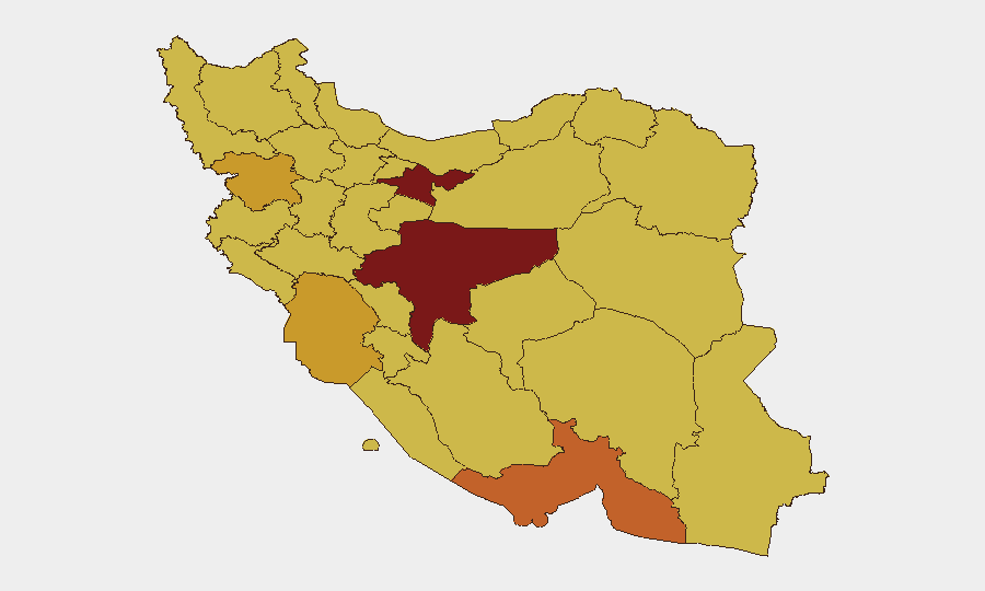
Iran faces acute military and political escalation following overnight U.S. strikes on Iranian naval and missile assets in the southern Gulf region, marking a significant breach of the April 8 ceasefire framework. The strikes have triggered elevated military alerts across Hormozgan Province and heightened diplomatic tensions, with Iranian officials signaling possible retaliatory action or proxy escalation. The composite national threat score of 100 reflects active military confrontation, internal political friction, and maritime security risks along critical global energy chokepoints.
Key Developments
- Bandar Abbas, Sirik, Jask (Hormozgan Province) – U.S. strikes on Iranian military infrastructure overnight 2026-06-01/02. Multiple explosions reported at missile launch sites, naval bases, and suspected mine-laying vessels near the Strait of Hormuz. Iranian air defenses activated; at least one U.S. drone reportedly engaged.
- Hormozgan Province – Iranian military placed on elevated alert. Revolutionary Guard and regular naval/air forces activated air-defense systems and expanded surveillance over coastal approaches and the Persian Gulf, indicating sustained readiness for follow-on U.S. operations.
- Strait of Hormuz and adjacent sea lanes – heightened maritime risk. U.S. strikes targeted boats allegedly preparing to lay mines near the critical shipping chokepoint; renewed risk to commercial vessels, insurance coverage, and routing decisions for energy transport.
- Tehran (National level) – Iranian retaliation threats and ceasefire violation accusations. Officials accused Washington of breaching April 8 ceasefire terms and warned of "consequences," signaling possible conventional or proxy response and deepening diplomatic rupture.
- Doha/Islamabad mediation track – ceasefire negotiations under severe strain. U.S. leadership characterized Iran's response to ceasefire proposals as "totally unacceptable," reducing confidence in near-term diplomatic resolution and increasing likelihood of protracted confrontation.
- Regional air and maritime surveillance – elevated U.S.–Iran engagement risk. Increased drone flights, air-defense activations, and mine-warfare preparations create higher probability of miscalculation or unintended escalation across the Gulf corridor.
- Internal Iranian political friction (2026-06-02 events). Reported citizen arrests and violent repression alongside disapproval directed at the President reflect domestic pressure and potential instability compounds external military risk.
Highest-Risk Areas
Tehran Province (100) and Isfahan Province (89.5) remain the national political and economic cores driving overall risk, with internal dissent and government response creating baseline instability. Hormozgan Province (74) has emerged as the most acute operational threat zone due to overnight military strikes, elevated alert status, and direct U.S.–Iran military contact. Kurdish-majority regions—Kurdistan (72.8) and East Azerbaijan (70.1)—remain structurally vulnerable to cross-border dynamics and proxy activity. The clustering of risk scores between 70–72 across Khuzestan, Ardabil, Fars, and Kerman reflects distributed ground-based military infrastructure and historical vulnerability to proxy and kinetic operations.
How GeoBit Would Assist
Duty-of-care teams would deploy AOI Monitoring & Early Warning on Hormozgan Province and maritime chokepoints to detect escalation signals in real time. Battle Mapping and Force Structure tracking would provide granular visibility into Iranian military repositioning and air-defense activity across coastal provinces. Maritime & Aviation Tracking combined with Satellite & Imagery Analysis would enable continuous monitoring of Strait of Hormuz shipping disruptions and U.S.–Iranian military posture, while Intel Sweep and multi-language OSINT would surface Iranian policy statements, proxy messaging, and regional actor positioning to forecast retaliation vectors.
7-Day Outlook
Expect continued elevated military alert in Hormozgan and adjacent Gulf provinces, with renewed diplomatic friction limiting near-term de-escalation. Risk of Iranian conventional or proxy retaliation remains elevated through mid-June, with maritime security and international shipping in the Strait of Hormuz as primary exposure vectors. Internal political tension and government response may compound external military risk, warranting heightened attention to Tehran and major urban centers.
Highest-Risk Areas — Ranked
| # | State / Region | Risk |
|---|---|---|
| 1 | Tehran Province | 100 |
| 2 | Isfahan Province | 89.5 |
| 3 | Hormozgan Province | 74 |
| 4 | Kurdistan Province | 72.8 |
| 5 | Khuzestan Province | 71 |
| 6 | Ardabil Province | 70.7 |
| 7 | Fars Province | 70.6 |
| 8 | Kerman Province | 70.6 |
| 9 | Yazd Province | 70.5 |
| 10 | East Azerbaijan Province | 70.1 |
| 11 | Semnan Province | 70.1 |
| 12 | Alborz Province | 70.1 |
Sources
Previous Daily Briefs
A new Iran brief is written every day — each with its own risk map and downloadable CSV. Here's the last week; use the calendar to go further back.
📅 Browse every day by calendar →
Highlighted days have a brief. Tap a day for that day's map & analysis, or “csv” for that day's dataset ($5).