Situation Summary
Iran is experiencing an acute escalation in conventional military conflict with the United States and regional actors, characterized by sustained U.S. airstrikes on Iranian military infrastructure and Iranian retaliatory strikes on commercial shipping and U.S.-linked facilities across the Persian Gulf region. Over the past 48 hours, Iran has transitioned from absorbing strikes to executing coordinated multi-wave missile and drone attacks on targets in Kuwait, Bahrain, and Jordan, while simultaneously conducting attacks on commercial vessels in the Strait of Hormuz. The conflict remains kinetic and actively escalating, with civilian casualties reported in Iran and maritime commerce under direct threat.
Key Developments
- Bushehr nuclear facility area struck (Jul 14–15, 2026): U.S. forces struck targets near the Bushehr nuclear power plant in southern Iran; Iranian health ministry reported at least 14 dead and 78 injured across multiple provinces from strikes over two days. This represents the first publicly acknowledged targeting near Iranian nuclear infrastructure in the current campaign.
- Hormozgan coastal bombardment (Jul 14–15, 2026): U.S. Central Command confirmed dozens of strikes on Iranian military sites in Bandar Abbas, Sirik, Qeshm Island, and Jask, targeting coastal defense, missile, and drone infrastructure supporting Strait of Hormuz operations. Iranian state media reported multiple explosions and civilian casualties including the family of a park ranger.
- Strait of Hormuz shipping attacks (Jul 14–15, 2026): At least three commercial tankers were struck by Iranian missiles and drones in the southern Strait approaches near Oman; at least one crew member killed and several injured. UK Maritime Trade Operations issued fresh warnings after targeting of multiple vessels.
- Iranian retaliation on Gulf shipping (Jul 14–15, 2026): Iran struck at least two oil tankers (Emirati and Saudi/Qatar-linked vessels) with cruise missiles, killing one crew member and injuring up to eight; Saudi Arabia and Qatar issued public condemnations.
- IRGC claims strike on Mina Abdullah (Jul 15, 2026): Iran's Islamic Revolutionary Guard Corps announced a strike on the U.S. logistics hub at Mina Abdullah, Kuwait, described as the fourth wave of "Operation Nasr 2." Independent confirmation of damage remains limited.
- Explosions reported in Kuwait and Bahrain (Jul 14–15, 2026): Multiple massive explosions reported in military areas of both nations, reportedly targeting fuel, ammunition depots, and air-defense systems in response to U.S. strikes on Iran.
- IRGC border buildup near Iraq (Jul 14, 2026): Enhanced Iranian deployments reported near the Iran–Iraq border and Iraqi Kurdistan, disclosed and emphasized amid the current crisis.
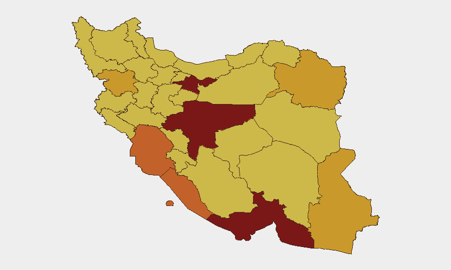
Highest-Risk Areas
Tehran Province (risk 100) remains the primary target for U.S. strikes and the epicenter of Iranian government and military command-and-control; Isfahan Province (90.5) and southern coastal regions—particularly Hormozgan (81.9), Bushehr (73), and Khuzestan (74.1)—face the highest near-term kinetic risk due to concentration of Iranian military infrastructure, nuclear facilities, and Strait-adjacent assets. Bushehr Province's proximity to nuclear infrastructure and recent targeting significantly elevates civilian collateral-damage exposure. Northern border provinces (Kurdistan, Sistan and Baluchestan) show elevated risk from IRGC deployments and potential cross-border spillover.
How GeoBit Would Assist
Security teams should employ Conflict & Military (force structure and weapons-capability tracking) to map real-time Iranian IRGC deployment patterns and Maritime & Aviation tracking to monitor live Strait of Hormuz vessel movements and incoming threats. AOI Monitoring & Early Warning on Tehran Province, Bushehr, Hormozgan, and border zones with persistent alerting provides 24/7 notice of strikes, explosions, and force movements. GIS & Spatial Analysis of strike patterns and Satellite & Imagery analysis confirm damage assessments and civilian impact.
7-Day Outlook
The conflict is expected to remain kinetic through at least the next week, with Iran sustaining multi-wave retaliatory strikes on Gulf U.S. facilities and commercial shipping while absorbing continued U.S. airstrikes on domestic military targets. Strait of Hormuz transit risk will remain acute; commercial insurers and shipping operators should expect further targeting. Risk of escalation to Israeli involvement or direct strikes on nuclear facilities remains present.
Highest-Risk Areas — Ranked
| # | State / Region | Risk |
|---|---|---|
| 1 | Tehran Province | 100 |
| 2 | Isfahan Province | 90.5 |
| 3 | Hormozgan Province | 81.9 |
| 4 | Khuzestan Province | 74.1 |
| 5 | Bushehr Province | 73 |
| 6 | Kurdistan Province | 72.9 |
| 7 | Sistan and Baluchestan Province | 72.3 |
| 8 | Razavi Khorasan | 71.6 |
| 9 | Ilam Province | 70.9 |
| 10 | Yazd Province | 70.7 |
| 11 | Gilan Province | 70.6 |
| 12 | Kohgiluye and Buyer Ahmad Province | 70.4 |
Sources
Previous Daily Briefs
A new Iran brief is written every day — each with its own risk map and downloadable CSV. Here's the last week; use the calendar to go further back.
📅 Browse every day by calendar →
Highlighted days have a brief. Tap a day for that day's map & analysis, or “csv” for that day's dataset ($5).
Atlas — our AI intelligence desk — emails them this snapshot personally. Nothing else, no list.