Situation Summary
Israel remains at composite threat level #4 globally, driven by active war and 669 tracked events, with the security situation characterized as unpredictable across major urban centers including Tel Aviv and Jerusalem. Conditional ceasefire negotiations with Lebanon have reduced immediate cross-border escalation risk in the north, but the South District remains the highest-risk sub-national zone due to ongoing Gaza operations and terrorism threats. Lone-actor and organized extremist plotting continues, and protest activity poses secondary risk of sudden civil unrest in population centers.
Key Developments
- Lebanon–Israel border (June 4, 2026): Israel and Lebanon agreed to conditional ceasefire terms; Hezbollah commitment to halt rocket and cross-border attacks is the trigger. This directly reduces immediate military escalation risk in the North District but remains contingent on compliance monitoring.
- Northern Israel, within 4 km of Lebanon/Syria border (June 4, updated advisory): U.S. government travel restrictions reaffirmed due to continued IDF military presence and activity; cross-border attack risk persists despite ceasefire talks.
- Ayalon Highway, Tel Aviv vicinity (June 4, 2026): Car explosion resulting in one fatality; Israeli police and security services have ruled out terrorism and are investigating as a criminal or technical incident. No security escalation indicated.
- Gaza perimeter, within 11.3 km exclusion zone (June 4, updated advisory): Do Not Travel designation remains in effect for all Gaza access and the 7-mile buffer zone; ongoing armed conflict and risk of sudden escalations cited.
- West Bank (June 4, reaffirmed advisory): Personal travel restrictions for U.S. officials remain in place except on three specified main routes (1, 90, 443); reflects ongoing terrorism and civil unrest risks tied to IDF–Palestinian frictions.
- Tel Aviv and Jerusalem (June 4, updated advisory): General unpredictability of security situation reaffirmed; terrorist plotting and lone-actor extremist activity remain active threats; crowds and demonstrations carry unrest risk.
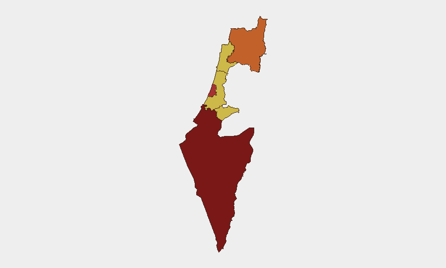
Highest-Risk Areas
The South District (risk score 100) dominates the threat landscape due to active military operations in and around Gaza, persistent terrorism threats, and the 11.3 km exclusion zone restricting movement and commerce. Tel Aviv (78.1) ranks second, reflecting its status as a major urban center vulnerable to both organized and lone-actor attacks, as well as secondary protest and civil-unrest risks. The North District (73.7) and Haifa District (70.9) remain elevated due to cross-border military activity with Lebanon and Syria, though the conditional ceasefire has provided tactical relief. Center and Jerusalem Districts (70.6 and 70 respectively) face baseline terrorism and unrest risks typical of high-density urban environments in active conflict zones.
How GeoBit Would Assist
Organizations with personnel or assets in Israel should employ AOI Monitoring & Early Warning to establish persistent watches on the South District, Gaza perimeter, and northern border zones, with automated alerts on military activity, ceasefire compliance signals, and protest clustering. Routing & Network Analysis combined with GIS & Spatial Analysis enables real-time alternative route planning for Tel Aviv and Jerusalem operations, accounting for live exclusion zones, checkpoint activity, and road closures. Intel Sweep and OSINT fusion across Israeli media, social platforms, and security statements provide daily sentiment and actor-intent corroboration to supplement official advisories.
7-Day Outlook
The ceasefire understanding with Lebanon, if held, will likely reduce northern military escalation and cross-border attack frequency over the next week. Conversely, Gaza operations and South District terrorism risk are expected to remain at current elevated levels. Tel Aviv and Jerusalem security should remain unpredictable; monitoring protest calendars and extremist narrative shifts via OSINT will be critical for duty-of-care planning.
Highest-Risk Areas — Ranked
| # | State / Region | Risk |
|---|---|---|
| 1 | South District | 100 |
| 2 | Tel-Aviv District | 78.1 |
| 3 | North District | 73.7 |
| 4 | Haifa District | 70.9 |
| 5 | Center District | 70.6 |
| 6 | Jerusalem District | 70 |
Previous Daily Briefs
A new Israel brief is written every day — each with its own risk map and downloadable CSV. Here's the last week; use the calendar to go further back.
📅 Browse every day by calendar →
Highlighted days have a brief. Tap a day for that day's map & analysis, or “csv” for that day's dataset ($5).