Situation Summary
Maldives maintains a low global threat profile (composite score 21, rank #null globally) with no verified major security incidents, civil unrest, or travel disruptions reported in the last 24–48 hours. The six tracked event signals in the system reflect routine diplomatic exchanges with Sri Lanka and domestic judicial–police procedural matters, none of which present immediate operational risk to corporate or resident populations. The security environment remains stable, though concentrated risk persists in the capital and surrounding atolls.
Key Developments
- 2026-06-10 · Public Statement · Sri Lanka–Maldives Diplomatic Exchange – Two consecutive public statements between Sri Lanka and Maldives on 10 June; no evidence of escalation, military mobilization, or maritime incident. Routine bilateral messaging.
- 2026-06-08 · Judicial–Police Procedural Events · Malé – Arrest/detain and investigative actions involving police, magistrate, and courts on 8 June; consistent with standard law-enforcement and judicial workflow. No mass detention, political arrests, or public disorder reported.
- No Active Security Incidents – Web and social-media search across the last 48 hours has not surfaced confirmed reports of terrorist activity, large-scale protests, infrastructure failure, or crime spikes affecting tourist zones, capital, or major atolls.
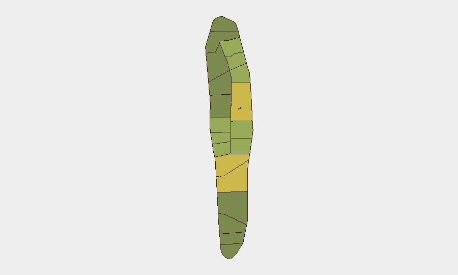
Highest-Risk Areas
Malé (risk 85) and Malé Atoll (68) dominate the sub-national ranking, reflecting the capital's concentration of government, commerce, maritime transit, and diplomatic activity—naturally elevating exposure to both petty crime and political volatility. Hadhdhunmathi (65) and Kolhumadulu (60) also present elevated composite scores, likely driven by population density and inter-atoll enforcement/judicial demand. Risk attenuates sharply beyond the capital zone; southern and remote atolls (North Miladhunmadulu, 45; North and South Nilandhe, 42–44; Ari Atoll, 40) carry substantially lower footprints. Organizations with personnel, offices, or supply chains in Malé should maintain standard duty-of-care monitoring; resort and tourism operations in outer atolls face minimal security friction.
How GeoBit Would Assist
Teams managing personnel or assets in Maldives should deploy AOI Monitoring & Early Warning on Malé and Malé Atoll to detect political friction, protest formation, or crime-pattern shifts in real time. OSINT Fusion (X/Telegram, multi-language search, sentiment analysis) across diplomatic and maritime channels will surface emerging Sri Lanka–Maldives tensions or irregular vessel activity before they reach mainstream media. Intelligence Sweep combined with Maritime & Aviation Tracking enables rapid validation of any closure, incident, or route disruption affecting commercial or evacuation corridors.
7-Day Outlook
No indicators suggest material deterioration in the next seven days. Routine diplomatic and judicial proceedings are likely to continue without disruption. Seasonal weather, tourism patterns, and regional maritime traffic remain the primary operational variables; corporate teams should maintain standard travel protocols and monitor foreign-ministry advisories for any revision to Maldives' status.
Highest-Risk Areas — Ranked
| # | State / Region | Risk |
|---|---|---|
| 1 | Malé | 85 |
| 2 | Malé Atoll | 68 |
| 3 | Hadhdhunmathi | 65 |
| 4 | Kolhumadulu | 60 |
| 5 | Felidhu Atoll | 58 |
| 6 | Mulaku Atoll | 55 |
| 7 | Faadhippolhu | 52 |
| 8 | South Miladhunmadulu | 48 |
| 9 | North Miladhunmadulu | 45 |
| 10 | South Nilandhe Atoll | 44 |
| 11 | North Nilandhe Atoll | 42 |
| 12 | South Ari Atoll | 40 |
Sources
Previous Daily Briefs
A new Maldives brief is written every day — each with its own risk map and downloadable CSV. Here's the last week; use the calendar to go further back.
📅 Browse every day by calendar →
Highlighted days have a brief. Tap a day for that day's map & analysis, or “csv” for that day's dataset ($5).