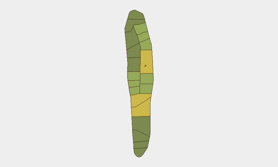
Situation Summary
Maldives remains a low-threat jurisdiction (global rank #140, composite score 12) with no tracked organized security events during the reporting period. However, street-level crime in the capital intensified marginally, including armed robbery, burglary with hostage-taking, and a serious motorcycle collision. Government attention to road safety, border security, and internal order has increased, reflected in new vehicle restrictions and heightened scrutiny of maritime activity near the capital.
Key Developments
- Malé, Galolhu — 8–12 October: Two men forced entry into a fourth-floor apartment, held occupants at knifepoint, and robbed cash; both suspects arrested and remanded on 12 October. This incident represents the most serious violent crime of the reporting period.
- Malé, Henveiru — 12 October: Police seized 826 bottles of alcohol from a residential building and arrested Mohamed Rashwan Abbas on suspicion of operating an illicit alcohol-supply network, indicating organized retail enforcement activity.
- Sinamalé Bridge highway — 17 October: A motorcycle traveling above 100 km/h struck a police checkpoint barricade at 04:29, seriously injuring an on-duty officer. This appears an isolated traffic incident rather than a security threat.
- Malé, Hulhumalé, and Sinamalé Bridge — announced 16 October: Authorities imposed morning restrictions on heavy vehicles (06:00–08:30) citing road safety and student traffic management.
- Malé maritime zone — 14–19 October: Government reaffirmed prohibition on foreign military or operational surveillance over Maldivian territory and waters, following reports of unauthorized vessels near the capital. No further details on vessel identity or intent were disclosed.
- Malé — 19 October: A 35-hour hunger strike outside a police station concluded after arrest of Ahmed Farish on charges including threatening behavior, property damage, assault, and obstructing police; he was remanded for 15 days.
- Rasmalé development area — 18 October: Religious scholar Sheikh Zamzam Farish alleged that the home minister warned him against discussing national-security concerns related to the project and raised questions about policing arrangements in the zone.
- Malé — 13–15 October: A national workshop on chemical and biological emergency preparedness was convened at Hotel Jen, covering hazard assessment, protective equipment, decontamination, and medical response protocols.
Highest-Risk Areas
Malé and Malé Atoll (risk scores 85 and 68 respectively) account for the majority of reported incidents and drive the national risk profile, reflecting population density, tourism concentration, and administrative centralization. Secondary risk clusters in Hadhdhunmathi (65) and Kolhumadulu (60) suggest localized crime or governance challenges, though reporting from outer atolls remains sparse. The capital's rising street crime—robbery, burglary, and traffic violence—and government enforcement activity (alcohol seizures, detentions for protest behavior) indicate ongoing order-maintenance efforts but no systemic instability.
How GeoBit Would Assist
Security teams protecting personnel or assets in Maldives should leverage GeoBit's AOI Monitoring & Early Warning capability to track crime clusters and police activity in Malé and neighboring atolls in near-real time. Intel Sweep and multi-language OSINT (news, social media, local radio) would surface emerging crime patterns, labor disputes, or maritime incidents before they escalate. Routing & Network Analysis could optimize staff travel on main corridors (Sinamalé Bridge, Hulhumalé) to avoid heavy-vehicle restrictions and checkpoint delays during peak hours.
7-Day Outlook
No major security events are anticipated in the coming week. Street-level crime in Malé is likely to remain sporadic but elevated relative to historical norms; travelers and residents should maintain standard urban vigilance. Government road-safety enforcement will persist; commuters should expect continued vehicle restrictions during morning peak hours and allow additional travel time.
Highest-Risk Areas — Ranked
| # | State / Region | Risk |
|---|---|---|
| 1 | Malé | 85 |
| 2 | Malé Atoll | 68 |
| 3 | Hadhdhunmathi | 65 |
| 4 | Kolhumadulu | 60 |
| 5 | Felidhu Atoll | 58 |
| 6 | Mulaku Atoll | 55 |
| 7 | Faadhippolhu | 52 |
| 8 | South Miladhunmadulu | 48 |
| 9 | North Miladhunmadulu | 45 |
| 10 | South Nilandhe Atoll | 44 |
| 11 | North Nilandhe Atoll | 42 |
| 12 | South Ari Atoll | 40 |
Sources
Previous Weekly Briefs
A new Maldives brief is written every Monday, covering the week — each with its own risk map and downloadable CSV. Use the calendar to go further back.
- October 13, 2026
- October 6, 2026
- September 29, 2026
- September 22, 2026
- September 15, 2026
- September 8, 2026
- September 1, 2026
📅 Browse past briefs by calendar →
Highlighted days have a brief. Tap a day for that day's map & analysis, or “csv” for that day's dataset ($5).
Atlas — our AI intelligence desk — emails them this snapshot personally. Nothing else, no list.