Situation Summary
Mali is experiencing a coordinated multi-front offensive that began in late April and has intensified dramatically as of 1–3 June 2026. Al-Qaeda-linked JNIM has declared a "total siege" of Bamako with blockaded access routes, while Islamic State in the Greater Sahara (ISGS) has simultaneously launched operations in the northeast near Ménaka, forcing Malian security forces and Russian-linked Africa Corps units into active defensive postures across the country. The capital and key garrison towns (Kati, Gao, Kidal, Sévaré) have all been targeted in coordinated assaults, and despite official claims of "control restoration," the threat environment remains volatile and degrading. The French government has issued an emergency evacuation directive for its nationals, signaling acute international concern about trajectory and civilian safety.
Key Developments
- Bamako siege declaration (1 June) – JNIM publicly announced a total siege of Mali's capital via video message, claiming all overland access routes are blocked and warning of death to those attempting entry; this directly elevates ambush and IED risk on national highways from Kayes, Sikasso, Ségou, and Koulikoro regions.
- Perimeter security operations, Bamako – Malian security forces and Africa Corps units continue intensive search-and-clear operations around key sites in the capital following coordinated weekend assaults; heightened checkpoints and mobile patrols remain in effect despite official reassurances.
- ISGS offensive, Ménaka (northeast) – Islamic State in the Greater Sahara fighters have entered Ménaka region, established checkpoints, and are actively attempting to capture the regional capital, creating a second major combat front and severely restricting civilian and commercial movement in the northeast.
- Africa Corps withdrawal, Kidal (far north) – Russian-linked Africa Corps confirmed a pullback from Kidal after large-scale attacks and sustained casualties; this retrenchment reduces state presence in a historically contested area and increases risk of Tuareg and jihadist repositioning over key desert infrastructure.
- Coordinated multi-city assault wave (late May–early June) – Simultaneous or near-simultaneous attacks struck Bamako, Kati (key military garrison), Gao, Kidal, and Sévaré, demonstrating operational coordination and the vulnerability of regime military infrastructure; ongoing clearance missions indicate attacks may recur.
- French evacuation directive (1–3 June) – France's Foreign Ministry issued an emergency order for all French nationals to leave Mali immediately, citing extreme volatility and direct response to the latest attack wave; this diplomatic signal reflects high confidence in near-term deterioration.
- Access route vulnerability – All primary land approaches to Bamako (national highways) are now assessed as elevated-risk zones for armed group checkpoints, ambushes, and IEDs, effectively constraining overland logistics and personnel movement into the capital.
Highest-Risk Areas
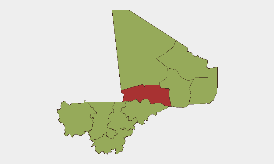
Timbuktu (78.7) stands significantly above all other regions and remains the primary driver of Mali's overall #22 global threat ranking due to sustained JNIM presence and insurgent control. The remaining nine regions—from Ménaka and Kayes through Mopti—cluster at 48.6, reflecting pervasive national instability; however, Ménaka's current ISGS activity and Kayes/Koulikoro/Ségou's status as siege-approach corridors to Bamako elevate operational risk for personnel and supply chains in those zones specifically. Bamako itself, despite being the capital and administrative center, carries a 48.6 composite score reflecting both the siege declaration and ongoing combat operations; Kidal's low state presence following Africa Corps withdrawal increases ungoverned-space risk in the far north.
How GeoBit Would Assist
Security teams should deploy AOI Monitoring & Early Warning on Bamako's perimeter and key approach highways to detect checkpoint activity and ambush positioning in real time. Routing & Network Analysis capabilities enable identification of alternative supply and evacuation routes bypassing siege corridors. Battle Mapping and force-structure tracking provide current visibility of Malian, Africa Corps, and insurgent positions to inform duty-of-care decisions on personnel movement and asset exposure.
7-Day Outlook
The siege posture and multi-front offensive are likely to persist or escalate through early June as JNIM and ISGS consolidate territorial gains and test regime response capacity. Additional coordinated attacks on military installations and administrative centers should be anticipated. Ground movement into and within Bamako will remain severely constrained; any personnel or asset movement should be deferred pending measurable security stabilization.
Highest-Risk Areas — Ranked
| # | State / Region | Risk |
|---|---|---|
| 1 | Timbuktu | 78.7 |
| 2 | Ménaka | 48.6 |
| 3 | Kayes | 48.6 |
| 4 | Taoudénit Region | 48.6 |
| 5 | Kidal | 48.6 |
| 6 | Gao | 48.6 |
| 7 | Bamako | 48.6 |
| 8 | Koulikoro | 48.6 |
| 9 | Ségou Region | 48.6 |
| 10 | Sikasso Region | 48.6 |
| 11 | Mopti | 48.6 |
Previous Daily Briefs
A new Mali brief is written every day — each with its own risk map and downloadable CSV. Here's the last week; use the calendar to go further back.
📅 Browse every day by calendar →
Highlighted days have a brief. Tap a day for that day's map & analysis, or “csv” for that day's dataset ($5).