Situation Summary
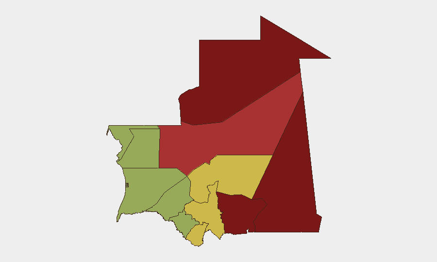
Mauritania remains a low-frequency, moderate-risk environment globally (rank #100), with a composite threat score of 11 across 7 tracked events. The security picture is dominated by persistent northeastern and eastern regional instability—particularly in Tiris Zemmour and the Hodh zones—driven by cross-border militant activity, resource competition, and limited state capacity. No acute escalation or new security incidents were detected in the last 24–48 hours. The overall trajectory remains stable but fragile, with endemic risks concentrated in remote border regions rather than major population centers.
Key Developments
No verified security, conflict, civil-unrest, crime, or travel-risk events were detected in Mauritania during the last 24–48 hours. A July 1 energy infrastructure agreement in N'Diago falls outside the event window and does not constitute a security development.
Recent Event Signal (exact date pending confirmation): Government administrative sanctions and an army public statement were logged on 2026-07-02 as the most recent flagged events; the substance and implications of these statements require additional source verification and will be tracked.
Health Monitoring (recent, no specific date): Rift Valley fever activity has been reported in both Mauritania and Senegal; public health and border screening protocols should remain heightened, particularly in the Senegal River regions (Gorgol, Guidimaka, Trarza).
Highest-Risk Areas
Tiris Zemmour (risk 95) and the eastern Hodh zones (Ech Chargui, 85; El Gharbi, 80) represent the primary concentration of subnational risk, driven by cross-border militant networks, weak governance infrastructure, and remote terrain that complicates state monitoring and rapid response. Adrar (78) and Tagant (68) face elevated secondary risk from similar structural vulnerabilities. By contrast, the central and southern regions (Brakna, Dakhlet Nouadhibou, below 50) and the capital's sphere of influence remain comparatively stable, suggesting that security concerns should be stratified by operational geography rather than treated as nationwide.
How GeoBit Would Assist
Security teams operating in Mauritania would benefit from persistent Area-of-Interest (AOI) monitoring and early warning covering Tiris Zemmour, Hodh Ech Chargui, and border crossing points to detect emerging incidents before they impact operations. Multi-language OSINT fusion (combining Telegram, X, local radio, and regional press) would provide real-time situational awareness and corroboration of government or military announcements such as the July 2 statement. Network and actor analysis, combined with conflict mapping, would help identify militant group movement patterns and sanctioned individuals affecting supply chains and personnel routing.
7-Day Outlook
No significant escalation is anticipated in the next seven days. Monitoring of government and military communications remains warranted to clarify the substance of the July 2 announcements. Rift Valley fever surveillance in border regions should continue; any cross-border health incident may trigger temporary administrative or movement restrictions affecting commercial and personnel operations.
Highest-Risk Areas — Ranked
| # | State / Region | Risk |
|---|---|---|
| 1 | Tiris Zemmour | 95 |
| 2 | Hodh Ech Chargui | 85 |
| 3 | Hodh El Gharbi | 80 |
| 4 | Adrar | 78 |
| 5 | Tagant | 68 |
| 6 | Guidimaka | 65 |
| 7 | Assaba | 62 |
| 8 | Gorgol | 58 |
| 9 | Trarza | 55 |
| 10 | Inchiri | 52 |
| 11 | Brakna | 48 |
| 12 | Dakhlet Nouadhibou | 45 |
Previous Daily Briefs
A new Mauritania brief is written every day — each with its own risk map and downloadable CSV. Here's the last week; use the calendar to go further back.
📅 Browse every day by calendar →
Highlighted days have a brief. Tap a day for that day's map & analysis, or “csv” for that day's dataset ($5).
Atlas — our AI intelligence desk — emails them this snapshot personally. Nothing else, no list.