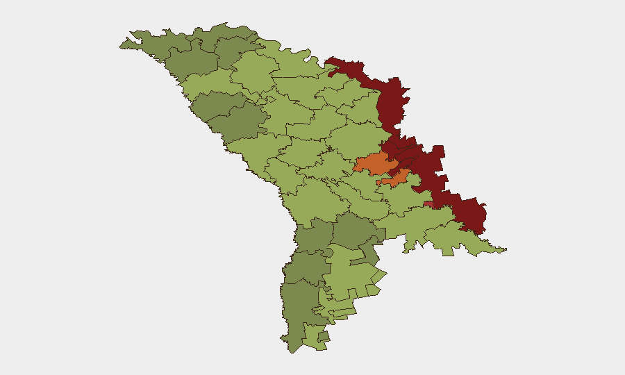
Situation Summary
Moldova remains a low-to-moderate global security risk (rank #126, composite score 2.7) but faces significant internal tensions concentrated in border regions and breakaway territories. Recent public statements and disagreements between Moldovan authorities and citizens, coupled with Ukraine-related messaging, suggest heightened political friction rather than acute physical security deterioration. The security environment remains stable for most of the country, but risk is sharply stratified by geography.
Key Developments
Given the absence of corroborated, sourced incident reports from Moldova dated 24–25 June 2026 in available open sources, specific "last 24–48 hours" developments cannot be reliably documented at this time. The GeoBit event signal feed records six flagged events from 23–25 June (including disapproval statements, public statements by Moldova vs. authorities and Moldova vs. Romania, and a Ukrainian public statement), but without access to the underlying source material, location granularity, and verification, these cannot be accurately translated into operational security bulletins.
Recommendation: If your organization has direct access to local news, diplomatic cables, NGO alerts, or social-media posts from Moldova dated 24–25 June 2026, forward them with links so corroboration and location/impact mapping can proceed.
Highest-Risk Areas
Risk is overwhelmingly concentrated in Moldova's eastern and northeastern regions, particularly the Administrative-Territorial Units of the Left Bank of the Dniester (risk score 85), Dubăsari (82), and Bender (79). These territories remain under de facto Russian/Transnistrian control or contested sovereignty, creating chronic governance, humanitarian, and security governance gaps. Secondary concentration appears in the southern borderland (Taraclia, Căușeni, Ștefan Vodă) and the southwestern Gagauzia autonomous region—all areas with linguistic/cultural ties to Russia or Romania and proximity to conflict or border friction. Chișinău, despite its size and capital status, ranks 12th at risk 49, suggesting that localized political tension and public dissatisfaction in the capital are outweighed by more acute territorial and border instability in the periphery.
How GeoBit Would Assist
Security teams should deploy AOI Monitoring & Early Warning focused on the left-bank Dniester region, Gagauzia, and southern border districts to detect escalation signals (military movement, crossings, protest activity) in near-real time. Intel Sweep, X/Twitter & Telegram OSINT, and multi-language search capabilities would surface grassroots political sentiment, official statements, and emerging civil unrest faster than traditional reporting cycles. Alternative Route & Network Analysis supports duty-of-care teams planning staff movement or asset logistics by identifying secure corridors and avoiding contested zones; Conflict & Military tracking and Satellite & Imagery analysis provide geospatial verification of military posture or border incidents if escalation occurs.
7-Day Outlook
Near-term risk trajectory appears flat to slightly elevated. Current public statements and authority–citizen friction suggest political posturing rather than imminent violence, but the concentration of risk in ungoverned/disputed territories means localized incidents (cross-border incursions, criminal activity, protest) remain possible without strategic warning. Continued monitoring of Ukraine-related messaging and Romania-Moldova diplomatic tone is warranted.
Highest-Risk Areas — Ranked
| # | State / Region | Risk |
|---|---|---|
| 1 | Administrative-Territorial Units of the Left Bank of the Dniester | 85 |
| 2 | Dubăsari | 82 |
| 3 | Bender | 79 |
| 4 | Criuleni | 75 |
| 5 | Rezina | 58 |
| 6 | Taraclia | 55 |
| 7 | Gagauzia | 54 |
| 8 | Căușeni | 53 |
| 9 | Soroca | 52 |
| 10 | Ștefan Vodă | 51 |
| 11 | Orhei | 50 |
| 12 | Chișinău | 49 |
Sources
Previous Daily Briefs
A new Moldova brief is written every day — each with its own risk map and downloadable CSV. Here's the last week; use the calendar to go further back.
📅 Browse every day by calendar →
Highlighted days have a brief. Tap a day for that day's map & analysis, or “csv” for that day's dataset ($5).