Situation Summary
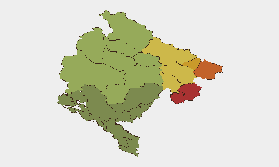
Montenegro remains a low-threat environment with a composite national threat score of 4 and no discrete security events recorded in the current tracking window. The country's overall stability is supported by steady EU accession progress and institutional dialogue, though governance concerns around intelligence-agency oversight have surfaced in civil-society discourse. Risk is geographically concentrated in the northern municipalities bordering Serbia and Kosovo, where historical fault lines, trafficking networks, and organized-crime activity persist.
Key Developments
- Podgorica, 18 June 2026 – Human Rights Action NGO and the Center for Investigative Journalism issued a joint statement calling for parliamentary oversight of the National Security Agency (ANB) following revelations that a former Armed Forces member with alleged Chetnik affiliations was hired by the agency. No physical security incident or unrest was reported; this reflects governance and press-freedom concerns within institutional channels.
- Podgorica/EU, 17–18 June 2026 – The European Parliament adopted its 2026 annual report on Montenegro's EU accession, noting steady progress in reforms and a target to complete EU negotiations by end-2026 and join by 2028. No associated protests, security disruptions, or travel warnings were documented.
- Podgorica, 18–19 June 2026 – The Central Bank of Montenegro completed a two-day working visit to Paris focused on EU integration dialogue with French financial institutions. No security or travel-risk concerns were linked to this engagement.
No credible reports emerged in the last 24–48 hours of large-scale protests, violent crime, terrorist activity, infrastructure failures, or new government/embassy security alerts affecting Montenegro.
Highest-Risk Areas
The northern municipalities of Plav (risk 78), Gusinje (76), Rožaje (74), Petnjica (72), and Andrijevica (68) dominate the risk landscape. These territories lie along the Serbia–Kosovo border and are historically linked to cross-border trafficking (narcotics, weapons, persons), organized-crime networks, and residual communal tensions. Risk declines sharply as one moves south and west; coastal and central regions register substantially lower threat profiles. Organizations with personnel or assets in the north should apply heightened due diligence and maintain awareness of border-area volatility, even in the absence of acute current incidents.
How GeoBit Would Assist
Security teams monitoring Montenegro should employ AOI (Area-of-Interest) Monitoring & Early Warning on the high-risk northern municipalities to detect emerging protest activity, trafficking patterns, or cross-border incidents before they escalate. Intel Sweep and multi-language OSINT (X/Twitter, local news, law-enforcement statements) provide continuous horizon-scanning for civil unrest, crime spikes, or policy shifts affecting travel and asset safety. Network & Actor Analysis and GIS & Spatial Analysis help correlate organized-crime and trafficking nodes with specific towns and border crossings, enabling targeted routing and journey-planning adjustments via Routing & Network Analysis for personnel transiting the north.
7-Day Outlook
No acute security catalyst is visible on the near-term horizon. EU accession momentum and institutional engagement suggest political stability will persist over the coming week. However, the northern border regions remain subject to seasonal trafficking fluctuations and sporadic criminal violence; organizations should maintain baseline vigilance and pre-positioned contingency protocols for personnel in those areas.
Highest-Risk Areas — Ranked
| # | State / Region | Risk |
|---|---|---|
| 1 | Plav Municipality | 78 |
| 2 | Gusinje Municipality | 76 |
| 3 | Rožaje Municipality | 74 |
| 4 | Petnjica Municipality | 72 |
| 5 | Andrijevica Municipality | 68 |
| 6 | Bijelo Polje Municipality | 65 |
| 7 | Berane Municipality | 62 |
| 8 | Plužine Municipality | 58 |
| 9 | Pljevlja Municipality | 55 |
| 10 | Šavnik Municipality | 52 |
| 11 | Žabljak Municipality | 50 |
| 12 | Kolašin Municipality | 48 |
Sources
Previous Daily Briefs
A new Montenegro brief is written every day — each with its own risk map and downloadable CSV. Here's the last week; use the calendar to go further back.
📅 Browse every day by calendar →
Highlighted days have a brief. Tap a day for that day's map & analysis, or “csv” for that day's dataset ($5).