Situation Summary
Montenegro remains a low-threat environment globally (#148), but faces concentrated security challenges in its northern municipalities and episodic localized incidents. The past week saw one major violent crime (the Danilovgrad shooting and subsequent suspect suicide on 2 September), sustained labor unrest in the coastal Bar Municipality, and multiple drug and border enforcement actions indicating organized-crime and trafficking activity. Constitutional anti-corruption reforms announced this week signal institutional strengthening, though enforcement gaps—exemplified by the Bijelo Polje hunger strike over judicial non-execution—remain a source of public grievance and instability risk.
Key Developments
- Danilovgrad / Herceg Novi (1–2 September): A 30-year-old Russian national fired on three employees at a shooting range in Strahinići near Danilovgrad on 31 August; following a major manhunt involving special police and military helicopter support, the suspect died by suicide in a forested area near Herceg Novi. National mourning was declared; motive remains under investigation.
- Kolašin (8 September): State prosecutors opened a case against eight individuals who unfurled a banner glorifying war criminal Ratko Mladić; the act is treated as potential incitement to hatred and division, raising extremism and public-order concerns.
- Bar Municipality (5–7 September): Former workers of the Primorka factory in Šušanj held protests over unpaid severance and stalled criminal complaints. After police banned road-blocking protests through 13 September for traffic safety, demonstrators announced daily 13:00–14:00 gatherings in front of Bar Municipality building starting 7 September.
- Bijelo Polje (7 September): The mother of a sexual-assault victim resumed a hunger strike in front of the local court, protesting that a convicted perpetrator remains free despite sentencing; reflects public pressure over judicial enforcement failures.
- Žabljak (7 September): Police arrested a 33-year-old Belarusian citizen driving under the influence of multiple psychoactive substances (methamphetamine, marijuana, benzodiazepines, amphetamine, cocaine), indicating serious road-safety and narcotics risk in the northern tourist area.
- Nikšić (6 September): Officers arrested a wanted man for violent behavior and seized marijuana and cocaine from an apartment block; ongoing narcotics enforcement.
- Nationwide (3 September): Police "Stranac" operation resulted in 253 enforcement actions against foreigners: 167 misdemeanor reports, 24 return orders, 3 expulsion/forced-removal orders, 18 residence cancellations, visa cancellations, and 10 border-crossing preventions; indicates heightened irregular-migration and foreign-national enforcement.
- Customs (5 September): Authorities seized over €55,000 in mixed currencies hidden in a vehicle headlight; suspect arrested. Suggests organized-crime or money-laundering activity.
- Parliament (3–4 September): Montenegro's Parliament adopted a constitutional amendment abolishing Government immunity in corruption cases, signaling anti-corruption institutional reform.
Highest-Risk Areas
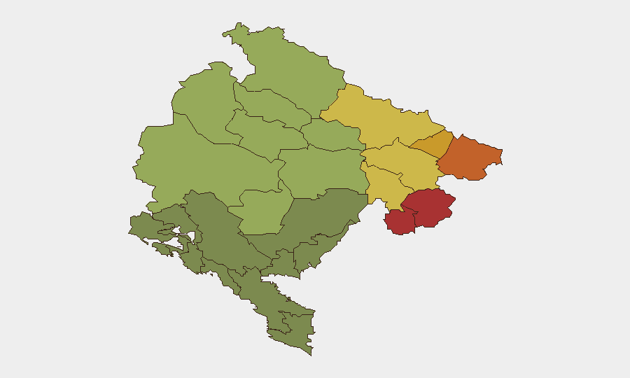
Northern municipalities—Plav (78), Gusinje (76), Rožaje (74), and Petnjica (72)—drive the composite threat ranking, likely reflecting organized-crime transit corridors, trafficking networks, and cross-border smuggling activity. Bijelo Polje (65) and Berane (62) show elevated risk, partly driven by narcotics enforcement and judicial-compliance failures. The northern cluster's proximity to the Serbian and Albanian borders, combined with rugged terrain and weak state presence, creates persistent vulnerabilities. Coastal areas (Bar) display lower baseline scores but face episodic labor unrest and migrant-processing pressures.
How GeoBit Would Assist
Security teams should employ AOI Monitoring & Early Warning on the northern border municipalities to detect trafficking and organized-crime activity; Network & Actor Analysis to map criminal and extremist groups (as evidenced by the Mladić banner incident); and Routing & Network Analysis for alternative travel and supply-chain planning around protest sites and enforcement operations. Intel Sweep and multi-language OSINT on Telegram and local media will provide real-time situational updates on labor unrest, judicial delays, and foreign-national incidents.
7-Day Outlook
The Bar Municipality labor protests are likely to sustain for 1–2 weeks without significant escalation, provided police maintain traffic controls. Narcotics and border enforcement will remain routine. Northern municipalities will continue to present baseline trafficking and smuggling risk. The constitutional reform on Government immunity may trigger political friction but is unlikely to create immediate security disruption.
Highest-Risk Areas — Ranked
| # | State / Region | Risk |
|---|---|---|
| 1 | Plav Municipality | 78 |
| 2 | Gusinje Municipality | 76 |
| 3 | Rožaje Municipality | 74 |
| 4 | Petnjica Municipality | 72 |
| 5 | Andrijevica Municipality | 68 |
| 6 | Bijelo Polje Municipality | 65 |
| 7 | Berane Municipality | 62 |
| 8 | Plužine Municipality | 58 |
| 9 | Pljevlja Municipality | 55 |
| 10 | Šavnik Municipality | 52 |
| 11 | Žabljak Municipality | 50 |
| 12 | Kolašin Municipality | 48 |
Sources
Previous Weekly Briefs
A new Montenegro brief is written every Monday, covering the week — each with its own risk map and downloadable CSV. Use the calendar to go further back.
- September 3, 2026
- August 31, 2026
- August 29, 2026
- August 26, 2026
- August 24, 2026
- August 22, 2026
- August 20, 2026
📅 Browse past briefs by calendar →
Highlighted days have a brief. Tap a day for that day's map & analysis, or “csv” for that day's dataset ($5).
Atlas — our AI intelligence desk — emails them this snapshot personally. Nothing else, no list.