Situation Summary
Niger remains ranked #26 globally in composite threat score (69.6), with security pressures concentrated in the Agadez Region and along the northern and eastern borders. The country continues to experience persistent terrorism, kidnapping, and state-fragility challenges consistent with the U.S. State Department's "Do Not Travel" advisory (current as of 30 January 2026). No major new incidents have been independently corroborated in open sources for the 24–48 hours ending 6 June 2026, though event signals from regional administrative and diplomatic channels suggest ongoing tensions, investigative activity, and potential abduction incidents involving Nigerian actors and institutions.
Key Developments
- Abduction incident reported (6 June): Nigerian entity allegedly involved in school-related abduction/hijacking/hostage situation; investigation status unclear. Specific location and casualty/hostage count not yet corroborated in independent reporting.
- Administrative and diplomatic friction (4–6 June): Multiple demand, rejection, disapproval, and investigative signals involving Nigerian and Niger state entities, plus African Development Bank public statement. No armed conflict reported; suggests administrative or policy dispute rather than kinetic escalation.
- Threat signal (4 June): Reported threat from unidentified "BOSS" entity toward Nigeria; context and specificity insufficient for tactical assessment without secondary confirmation.
- No major militant attacks corroborated (24–48h): Open-source reporting for 4–6 June contains no timestamped, geolocated al-Qaeda or ISIS-affiliated attacks in Niger proper, despite ongoing Sahel-wide jihadist activity patterns documented through 2025–26.
Note: Event signals from GeoBit's tracking system suggest diplomatic and administrative activity; however, credible incident details (location, casualty, tactical context) for the last 48 hours remain limited in publicly available sources.
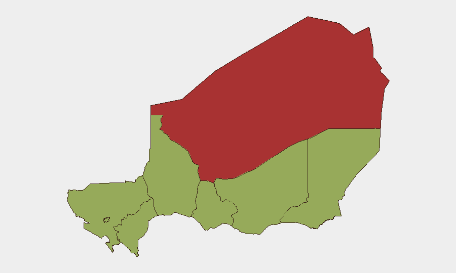
Highest-Risk Areas
Agadez Region dominates sub-national risk (78.7), substantially above all other areas, reflecting its history as a militant staging ground, trafficking hub, and zone of limited state presence. Zinder, Diffa, Tillabéri, and Tahoua regions each register moderate risk (48.7), forming a crescent of vulnerability across Niger's east, north, and west—consistent with documented jihadist presence and cross-border militant activity from Mali, Burkina Faso, and Lake Chad basin. Niamey and Maradi, though rated equivalent to these regions, carry heightened risk due to population density, administrative concentration, and urban crime. Organizations with personnel or assets should weight contingency planning toward Agadez withdrawal or shelter-in-place protocols and assume cross-border incident spillover into Zinder and Diffa.
How GeoBit Would Assist
AOI Monitoring & Early Warning with persistent watch on Agadez and Diffa allows 24/7 detection of militant movement, checkpoint activity, or humanitarian access disruption. Conflict & Military tracking (force structure, weapons capability) paired with Network & Actor Analysis enables identification of jihadist cell regrouping or leadership changes affecting kidnapping/extortion risk. Routing & Network Analysis supports alternative journey planning for personnel transiting northern or eastern zones, incorporating real-time threat data to avoid high-risk corridors.
7-Day Outlook
No dramatic escalation is anticipated in the near term absent a major jihadist attack or coup-related shock. Administrative tensions may persist, but open conflict indicators remain subdued in available reporting. Organizations should maintain current security postures, refresh personnel briefings on Agadez volatility, and activate local alert networks (embassy notifications, NGO security coordination) to close the gap between open-source reporting delays and operational need-to-know timelines.
Highest-Risk Areas — Ranked
| # | State / Region | Risk |
|---|---|---|
| 1 | Agadez Region | 78.7 |
| 2 | Zinder Region | 48.7 |
| 3 | Diffa Region | 48.7 |
| 4 | Tillabéri Region | 48.7 |
| 5 | Niamey | 48.7 |
| 6 | Tahoua Region | 48.7 |
| 7 | Dosso Region | 48.7 |
| 8 | Maradi Region | 48.7 |
Sources
Previous Daily Briefs
A new Niger brief is written every day — each with its own risk map and downloadable CSV. Here's the last week; use the calendar to go further back.
📅 Browse every day by calendar →
Highlighted days have a brief. Tap a day for that day's map & analysis, or “csv” for that day's dataset ($5).