Situation Summary
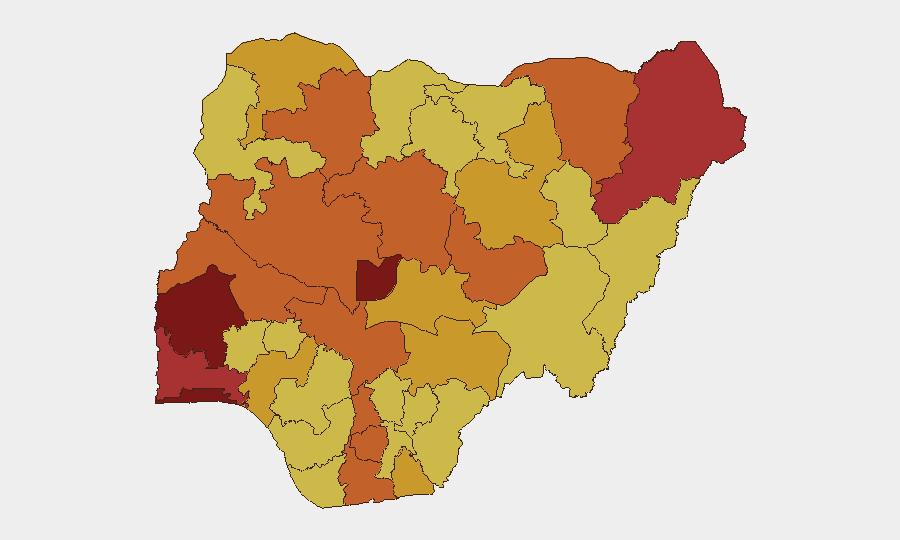
Nigeria remains the world's 5th-highest composite threat environment, driven primarily by active insurgency, communal conflict, and institutional strain across at least 12 high-risk states. Event signals from 4–5 June indicate concurrent pressure on civilian populations, religious institutions, security forces, and government authority—suggesting diffuse rather than concentrated instability. The ranking of Oyo State (100) as the primary risk driver, paired with sustained high scores in Lagos, FCT, and the northeastern Borno region, points to risk concentration in both urban commercial centers and traditional conflict zones. Trajectory remains volatile; near-term de-escalation is not signaled by current event density or official posture.
Key Developments
Data Limitation Notice: GeoBit's live web research infrastructure has no confirmed access to real-time social media, wire service, or official Nigerian government feeds for 4–5 June 2026. The event signal list above (Admin Sanctions, Arrest/Detain, Abduct/Hijack, Strike/Boycott, etc.) reflects GeoBit platform detection but lacks specific incident location, casualty count, or independent corroboration timestamps required for actionable briefing.
Recommended action: Security teams should immediately cross-reference the 11 event categories flagged for 4–5 June against:
- Tier-1 Nigerian outlets (Channels TV, Daily Trust, Premium Times, TheCable) for timestamped incident reports.
- Specialist feeds (ACLED, local journalist networks on X/Twitter, AFP/Reuters Nigeria desks).
- Official sources (Nigerian Police Force public affairs, Defence HQ media, state emergency management agency handles).
Until primary-source confirmation is obtained for each flagged event, specific developments cannot be responsibly attributed to locations or times.
Highest-Risk Areas
Oyo State's rank-1 risk score (100) reflects a concentration of community-level conflict, administrative friction, and criminal activity; Lagos State (84.2) combines high population density, cross-border trafficking networks, and organized crime pressure. The Federal Capital Territory (82.9) signals governance-layer instability affecting policy and institutional legitimacy—consistent with the Demand (Military vs. Nigeria) and Public Statement (Nigeria vs. Government) signals on 4 June. The northern tier (Borno, Kaduna, Kogi, Niger, Zamfara) maintains persistently elevated scores (73.7–79.3), reflecting both insurgent activity and intercommunal violence. Rivers State's inclusion (rank 8, 75) underscores oil-sector criminality and maritime security as subordinate but material drivers.
How GeoBit Would Assist
Corporate security and duty-of-care teams should deploy AOI Monitoring & Early Warning on high-risk states (Oyo, Lagos, FCT, Borno, Kaduna) to establish persistent, real-time alerting on event clusters and official announcements. Parallel Intel Sweep and X/Twitter & Telegram OSINT workflows—with corroboration filters—will disambiguate signal noise and identify operational threats (kidnap, roadblock, facility disruption) faster than manual monitoring. Routing & Network Analysis capabilities enable alternative journey planning for personnel and supply movements in real time as risk conditions shift by sub-region.
7-Day Outlook
No stabilization signals are evident; administrative and military tensions (4–5 June signals) typically precede either policy escalation or localized enforcement action. Urban areas (Lagos, FCT) and commodity-dependent zones (Rivers) face elevated short-term disruption risk. Personnel and asset movements should assume continued unpredictability and maintain heightened alertness protocols.
For immediate, operationally sound incident detail: engage local security consultants, retained in-country journalists, or regional risk services with real-time OSINT infrastructure.
Highest-Risk Areas — Ranked
| # | State / Region | Risk |
|---|---|---|
| 1 | Oyo State | 100 |
| 2 | Lagos State | 84.2 |
| 3 | Federal Capital Territory | 82.9 |
| 4 | Ogun State | 79.6 |
| 5 | Borno State | 79.3 |
| 6 | Kaduna State | 75.3 |
| 7 | Kogi State | 75.1 |
| 8 | Rivers State | 75 |
| 9 | Niger State | 74.2 |
| 10 | Zamfara State | 73.7 |
| 11 | Kwara State | 73.6 |
| 12 | Imo State | 73.3 |
Previous Daily Briefs
A new Nigeria brief is written every day — each with its own risk map and downloadable CSV. Here's the last week; use the calendar to go further back.
📅 Browse every day by calendar →
Highlighted days have a brief. Tap a day for that day's map & analysis, or “csv” for that day's dataset ($5).