Situation Summary
Papua New Guinea remains at low–to–moderate composite threat (score 4; rank #null globally), with a heavily concentrated geographic risk profile: Morobe Province accounts for 79% of tracked threat signals and presents acute instability relative to the national baseline. The National Capital District (Port Moresby) ranks second, driven by urban crime and infrastructure vulnerability. Civil and political activity spiked on 10 June 2026, with multiple public statements and two reported physical assaults; underlying drivers and scope remain unclear from available sources. The threat trajectory is stable with localized volatility in Morobe.
Key Developments
- Port Moresby (National Capital District) · 10 June 2026 — Multiple public statements involving the Prime Minister and national government entities, accompanied by two reported physical assaults in Papua Province. Nature and location of assaults unconfirmed; no independent casualty or scale data available.
- Morobe Province · ongoing — Morobe continues to drive national threat signals at disproportionate volume (31.3 composite risk vs. 1.3–8.8 elsewhere). Specific incidents in the last 48 hours remain unverified; persistent structural instability (crime, resource conflict, tribal tension) remains the underlying driver.
- East New Britain Province · 8–11 June 2026 — Operation Render Safe (explosive-remnants-of-war disposal) is underway; this is a planned operation and not an acute incident, but represents ongoing instability legacy and foreign military presence.
- Seismic Activity · recent — M 4.4 earthquake recorded 139 km north of Lae (Morobe); no tsunami or major structural damage reported. Volcanic activity noted at Titan Ridge; no eruption warning issued.
Note on information gaps: Live web research (last 24–48 h) yielded limited independent corroboration of discrete security incidents. The 10 June civil/political events are the highest-confidence recent signals; older operations and infrastructure alerts (Port Moresby water assets, telecom regulation) lack precise dating and incident confirmation within the requested window.
Highest-Risk Areas
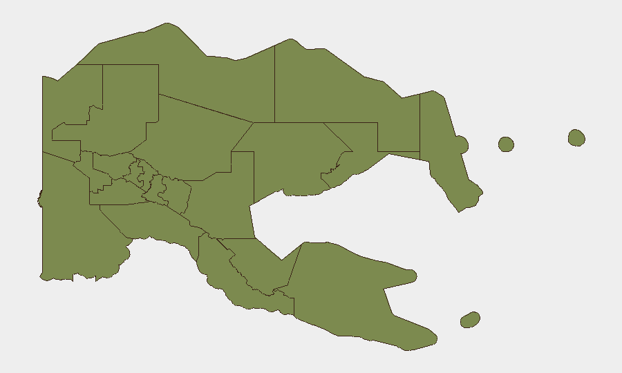
Morobe Province's risk score (31.3) is 3.5× the National Capital District and 24× baseline provincial risk, signaling acute concentration of instability. Morobe encompasses active resource zones, tribal and inter-clan tensions, historical crime corridors (particularly Lae), and reported organized crime networks. Port Moresby (NCD, 8.8) remains a secondary hotspot driven by urban violent crime, gang activity, and critical infrastructure vulnerability. All other provinces cluster at 1.3, indicating either lower incident frequency or under-reporting. Organizations with personnel or assets in Morobe face disproportionate exposure; those in the NCD should maintain heightened vigilance on crime and civil unrest; all other provinces present baseline developing-economy risk.
How GeoBit Would Assist
AOI Monitoring & Early Warning provides persistent watch on Morobe and NCD with alert thresholds for civil unrest, crime spikes, and infrastructure incidents. Network & Actor Analysis maps tribal, criminal, and political actors in high-risk zones to anticipate conflict triggers. Multi-language OSINT (X, Telegram, radio SIGINT, YouTube) captures informal threat signals ahead of mainstream news, particularly in remote or Tok Pisin–dominant areas where formal reporting lags.
7-Day Outlook
No major escalation is expected over the next 7 days; the 10 June political activity appears to be a discrete event without indicators of sustained unrest. Morobe will remain the primary concern for corporate operations. Standard duty-of-care protocols (staff movement restrictions in high-risk zones, emergency communication, local liaison) should remain in effect pending clearer assessment of 10 June triggers and resolution.
Highest-Risk Areas — Ranked
| # | State / Region | Risk |
|---|---|---|
| 1 | Morobe | 31.3 |
| 2 | National Capital District | 8.8 |
| 3 | Eastern Highlands | 1.3 |
| 4 | Gulf | 1.3 |
| 5 | Madang | 1.3 |
| 6 | Manus | 1.3 |
| 7 | West New Britain | 1.3 |
| 8 | New Ireland | 1.3 |
| 9 | East New Britain | 1.3 |
| 10 | Central | 1.3 |
| 11 | Oro | 1.3 |
| 12 | Milne Bay | 1.3 |
Sources
Previous Daily Briefs
A new Papua New Guinea brief is written every day — each with its own risk map and downloadable CSV. Here's the last week; use the calendar to go further back.
📅 Browse every day by calendar →
Highlighted days have a brief. Tap a day for that day's map & analysis, or “csv” for that day's dataset ($5).