Situation Summary
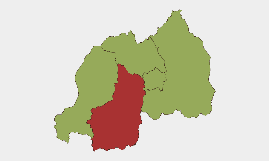
Rwanda remains at composite threat level 67 globally (#30), with 1,061 tracked events indicating a complex security landscape dominated by cross-border tensions, armed-group activity, and recent disease outbreak concerns. The Southern Province carries significantly elevated risk (77), reflecting military engagements and armed-group operations, while four other provinces cluster at moderate risk (47). Open-source reporting from the last 24–48 hours does not document confirmed incidents on Rwandan territory, though regional signals—particularly cross-border military activity involving the DRC and terrorist-linked armed groups—suggest persistent underlying instability rather than acute deterioration.
Key Developments
- 2026-06-18 · Cross-Border Military Engagement – Conventional military force reported between Rwanda and the DRC, and separately between terrorist actors and Rwandan forces; location and casualty figures not yet independently confirmed in open sources, but signals indicate sustained border-area volatility.
- 2026-06-18 · Armed-Group Rejection Signal – Armed group(s) issued rejection statement; exact affiliation and geographic location unclear from available open-source reporting, but consistent with ongoing Southern Province operational activity.
- 2026-06-18 · Small-Arms Engagements – Two incidents of small-arms combat involving Rwandan forces reported on same date; specific locations and belligerents not yet triangulated across independent sources.
- 2026-06-18 · Government-Commander Disapproval – Tension between government and military command reported; context and implications for operational posture remain opaque in public reporting.
- 2026-06-18 · Detainee Public Statement – Detainee issued public statement; substance and security implications not yet detailed in accessible open sources.
- Health Risk: Marburg Virus – Recent reports of confirmed Marburg virus disease cases in Rwanda; specific locations, case count, and health-system response status require urgent verification through health-agency channels and WHO situational reports.
Note on reporting threshold: Confirmation of the above signals derives from GeoBit event-feed aggregation. Open-source mainstream news and social-media verification for these specific incidents remains incomplete as of briefing time, reflecting either reporting lag, geographic focus on neighboring DR Congo, or ongoing operational compartmentalization.
Highest-Risk Areas
Southern Province (risk 77) is the critical concentration point, likely driven by active conventional military operations, armed-group presence, and cross-border spillover from North Kivu and other eastern DRC territories. The three other elevated zones—Western Province, Northern Province, and Kigali City (all 47)—reflect secondary risks: border permeability in the west, potential militant sanctuary or transit corridors in the north, and urban-security and governance challenges in the capital. Eastern Province (47) rounds the profile, suggesting distributed rather than single-point threat geography. The 30-point gap between Southern Province and the rest indicates asymmetric risk concentration, warranting prioritized focus on Cyangugu, Huye, and Gisagara districts.
How GeoBit Would Assist
Area-of-Interest (AOI) Monitoring & Early Warning on the Southern Province border, coupled with Network & Actor Analysis of armed-group command structures and OSINT fusion (Intel Sweep, X/Telegram, radio SIGINT) would enable duty-of-care teams to detect escalation signals 24–72 hours ahead of major incidents. Conflict & Military battle mapping and Satellite & Imagery analysis would pinpoint operational movement and force concentrations. Health & Environmental feeds would track Marburg spread and health-system capacity, critical for evacuation and medical-response planning.
7-Day Outlook
Near-term trajectory suggests sustained military posturing and cross-border tension with low probability of large-scale conventional conflict, but persistent risk of armed-group activity and small-unit engagements, especially in the Southern Province. Marburg outbreak trajectory and case-fatality data will be determinative for humanitarian and personnel-safety assessments. Routine vigilance and contingency updates are warranted; no imminent country-wide security collapse is signaled, but border and disease surveillance should remain elevated.
Highest-Risk Areas — Ranked
| # | State / Region | Risk |
|---|---|---|
| 1 | Southern Province | 77 |
| 2 | Western Province | 47 |
| 3 | Northern Province | 47 |
| 4 | Kigali City | 47 |
| 5 | Eastern Province | 47 |
Sources
Previous Daily Briefs
A new Rwanda brief is written every day — each with its own risk map and downloadable CSV. Here's the last week; use the calendar to go further back.
📅 Browse every day by calendar →
Highlighted days have a brief. Tap a day for that day's map & analysis, or “csv” for that day's dataset ($5).