Situation Summary
Saint Vincent and the Grenadines remains at global rank #66 with a composite threat score of 21—a relatively low-risk profile for the Caribbean region. No widespread civil unrest, political instability, or major domestic security incidents have been reported in the last 24–48 hours. The primary confirmed incident involves a maritime casualty affecting Vincentian nationals in offshore waters near Trinidad and Tobago, rather than a domestic threat.
Key Developments
- Maritime Incident – Offshore (Trinidad & Tobago waters) · 2026-06-29 to 2026-07-01: A St Vincentian fishing or commercial vessel sank in Trinidadian territorial waters; five crew members of Vincentian nationality are reported missing and presumed dead. The incident has generated concern within Saint Vincent's media and local stakeholder networks but does not directly impact on-island security posture.
- Administrative/Judicial Matters – Saint George · 2026-06-30: A magistrate issued administrative sanctions; concurrent judicial dispute between a judge and mayor was formally rejected. Both developments are routine administrative proceedings without indicated security or public-order implications.
- Organized Crime Signals – National · 2026-06-29: GeoBit's event feed registered disapproval signals linked to organized-crime entities and national governance bodies. Web research did not corroborate active, ongoing organized-crime incidents or inter-gang violence in the 24–48 hour window; signals may reflect regulatory or investigative actions rather than acute incidents.
- No Civil Unrest or Political Disturbance · Last 48 hours: Open-source monitoring confirmed absence of protests, riots, emergency decrees, mass arrests, or coup-related activity.
- No Major Crime or Infrastructure Attacks · Last 48 hours: No terrorism, armed robbery surges, kidnapping, or critical infrastructure disruption reported in the immediate reporting window.
Highest-Risk Areas
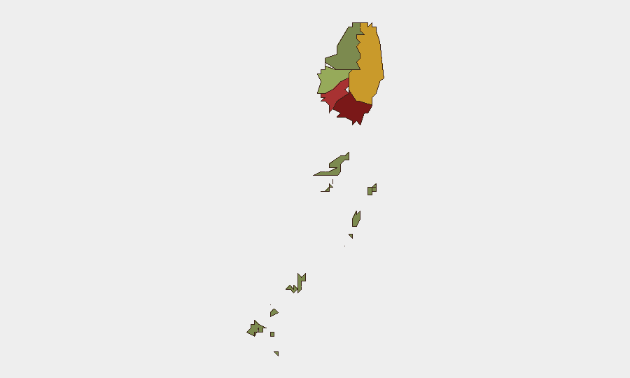
Saint George (risk 92) and Saint Andrew (risk 78) are the two highest-risk parishes and together account for a substantial portion of the national threat profile. Charlotte (71) and Saint Patrick (58) represent secondary risk concentrations. The Grenadines (12) remain the lowest-risk sub-region. Urban parishes in the northwestern leeward coast, particularly around Kingstown (Saint George), likely drive elevated scores through proximity to economic activity, port operations, and historical crime clustering; Saint Andrew's ranking suggests similar urban vulnerability factors. Saint David and the Grenadines' lower scores reflect smaller populations, less transshipment activity, and reduced inter-agency friction points.
How GeoBit Would Assist
Security teams operating in Saint Vincent should employ AOI Monitoring & Early Warning (persistent watch on Saint George, Saint Andrew, and Charlotte parishes with automated alerting for unrest, crime spikes, or port-related incidents); Intel Sweep and multi-language OSINT fusion (to detect organized-crime network activity, regulatory actions, and informal security developments before they escalate); and Maritime & Aviation tracking (to monitor vessel movements, transhipment routes, and casualty patterns in the exclusive economic zone, particularly given the recent offshore incident). Routing & Network Analysis can assist duty-of-care teams in identifying safer transit corridors between high-risk parishes.
7-Day Outlook
No imminent domestic instability or acute security deterioration is forecast for the next seven days. Organized-crime activity and port-side risks warrant continued monitoring in Saint George and Saint Andrew. The maritime incident may prompt increased coastal regulation or search-and-rescue operations but is unlikely to trigger broader policy shifts affecting land-based corporate operations.
Highest-Risk Areas — Ranked
| # | State / Region | Risk |
|---|---|---|
| 1 | Saint George | 92 |
| 2 | Saint Andrew | 78 |
| 3 | Charlotte | 71 |
| 4 | Saint Patrick | 58 |
| 5 | Saint David | 34 |
| 6 | Grenadines | 12 |
Sources
Previous Daily Briefs
A new Saint Vincent brief is written every day — each with its own risk map and downloadable CSV. Here's the last week; use the calendar to go further back.
📅 Browse every day by calendar →
Highlighted days have a brief. Tap a day for that day's map & analysis, or “csv” for that day's dataset ($5).